About Panay
Panay is a stratovolcano rising to 501 meters (1,644 feet) in Philippines's Western Pacific Volcanic Regions. No historical eruptions have been recorded, though the volcano is classified based on geological evidence of past activity.
Geography & Climate
Panay is located in Philippines, within the Luzon Volcanic Arc of the broader Western Pacific Volcanic Regions. Situated at 13.72° N, 120.89° E in the Northern Hemisphere, the volcano lies within a tropical climate zone. With a summit elevation of 501 meters above sea level, Panay is a moderately sized peak that remains accessible to hikers and researchers for much of the year. The volcanic landform is characterized as a composite, which describes the physical shape and structure of the volcanic edifice as observed from the surface.
GVP Reference Summary
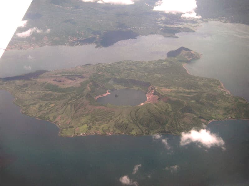
Mount Panay is a low andesitic stratovolcano on the Calumpang Peninsula west of the Batangas Bay, south of Lake Taal. Panay was mapped as Pleistocene in age by the Philippine Bureau of Mines (Wolf and Self, 1983), but displays strong solfataric activity. Batangas Bay lies at the intersection of two major regional trends, the Bataan Lineament and the Palawan-Macolod Lineament, and may represent a submarine caldera.
— Smithsonian Institution, Global Volcanism Program
0 Recorded Eruptions
No eruption records available for Panay.
Real-Time Data
Frequently Asked Questions About Panay
Is Panay an active volcano?+
Panay is not currently classified as active. Its activity evidence is listed as "unknown." No recorded eruptions have been documented. However, no volcano is ever considered permanently extinct.
How high is Panay?+
Panay has a summit elevation of 501 meters (1,644 feet) above sea level. At 501 meters, it is a relatively low-elevation volcano.
What type of volcano is Panay?+
Panay is classified as a Stratovolcano. Stratovolcanoes (also called composite volcanoes) are steep, conical volcanoes built up by many layers of hardened lava, tephra, and volcanic ash. They are among the most common and dangerous types, known for explosive eruptions.
Where is Panay located?+
Panay is located in Philippines, in the Western Pacific Volcanic Regions. More specifically, it lies within the Luzon Volcanic Arc. Its exact coordinates are 13.723° latitude, 120.893° longitude.
Is it safe to visit Panay?+
Panay can generally be visited, but as with any volcano, visitors should check local conditions and any advisory notices before traveling. Philippines may have specific regulations for accessing volcanic areas. Guided tours are often the safest and most informative way to experience a volcano.