About Taal
Taal is a caldera rising to 311 meters (1,020 feet) in Philippines's Western Pacific Volcanic Regions. The volcano is currently active, with its most recent eruption in 2025 CE. The volcano has produced 20 recorded eruptions, with a maximum Volcanic Explosivity Index (VEI) of 4.
Geography & Climate
Taal is located in Philippines, within the Luzon Volcanic Arc of the broader Western Pacific Volcanic Regions. Situated at 14.01° N, 121.00° E in the Northern Hemisphere, the volcano lies within a tropical climate zone. At just 311 meters above sea level, Taal is a relatively low-elevation volcanic feature. Despite its modest height, it remains an active geological formation with the same underlying magmatic processes as its taller counterparts. The volcanic landform is characterized as a caldera, which describes the physical shape and structure of the volcanic edifice as observed from the surface.
Geological Context
Taal sits in a subduction zone, where one tectonic plate dives beneath another, creating intense heat and pressure that generates magma. Subduction zones are responsible for many of the world's most explosive volcanoes and deadliest eruptions. For communities in Philippines near Taal, this tectonic setting means the volcano is capable of producing powerful explosive eruptions, pyroclastic flows, and lahars that can threaten populated areas within tens of kilometers of the summit. The dominant rock type is andesite / basaltic andesite, a dark, fine-grained volcanic rock that forms from rapidly cooling, low-viscosity lava. Basaltic eruptions tend to be less explosive and produce fluid lava flows that can travel long distances. While less immediately dangerous than explosive eruptions, basaltic lava flows can destroy structures and infrastructure in their path, and volcanic gases released during these eruptions can affect air quality over a wide area.
Eruption History Summary
Taal has 20 recorded eruptions in the geological database, spanning from 1873 CE to 2024 CE. The most powerful recorded event was a cataclysmic eruption with ash columns reaching the stratosphere in 2020 CE, reaching VEI 4 on the Volcanic Explosivity Index. Notable eruptions include 2020 CE (VEI 4), 1966 CE (VEI 3), 1965 CE (VEI 4). With an average interval of roughly 8 years between eruptions over a span of 151 years, this is one of the more frequently active volcanoes in the database. This persistent activity suggests a robust and well-supplied magma system beneath the volcano. With eruptive activity as recently as 2024 CE, Taal remains an actively monitored volcano.
Significance
With a maximum recorded VEI of 4, Taal has demonstrated the capacity for significant explosive eruptions that can impact regional aviation, agriculture, and communities tens of kilometers from the summit. VEI 4 eruptions produce ash columns reaching 15-25 kilometers into the atmosphere. Its 20 recorded eruptions make it one of the most prolific volcanoes in our database, reflecting a persistent and well-documented eruptive history that has provided volcanologists with extensive data for understanding eruption patterns and forecasting future activity. Given its recent activity, Taal is closely monitored by geological survey organizations to provide early warning of future unrest.
GVP Reference Summary
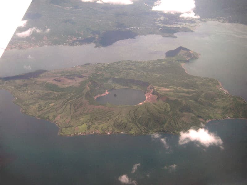
Taal is one of the most active volcanoes in the Philippines and has produced some powerful eruptions. The 15 x 20 km Talisay (Taal) caldera is largely filled by Lake Taal, whose 267 km2 surface lies only 3 m above sea level. The maximum depth of the lake is 160 m, with several submerged eruptive centers. The 5-km-wide Volcano Island in north-central Lake Taal is the location of all observed eruptions. The island is composed of coalescing small stratovolcanoes, tuff rings, and scoria cones. Powerful pyroclastic flows and surges have caused many fatalities.
— Smithsonian Institution, Global Volcanism Program
20 Recorded Eruptions
| Year | VEI | Type | Area |
|---|---|---|---|
| 2024 | 2 | Confirmed Eruption | — |
| 2022 | 1 | Confirmed Eruption | — |
| 2021 | 1 | Confirmed Eruption | — |
| 2021 | 2 | Confirmed Eruption | Main Crater |
| 2020 | 4 | Confirmed Eruption | — |
| 1977 | 2 | Confirmed Eruption | SW flank (near Mt. Tabaro) |
| 1976 | 2 | Confirmed Eruption | SW flank (near Mt. Tabaro) |
| 1970 | 1 | Confirmed Eruption | SW flank (near Mt. Tabaro) |
| 1969 | 2 | Confirmed Eruption | SW flank (near Mt. Tabaro) |
| 1968 | 2 | Confirmed Eruption | SW flank (near Mt. Tabaro) |
| 1967 | 1 | Confirmed Eruption | SW flank (near Mt. Tabaro) |
| 1966 | 3 | Confirmed Eruption | SW flank (near Mt. Tabaro) |
| 1965 | 4 | Confirmed Eruption | SW flank (near Mt. Tabaro) |
| 1911 | 3 | Confirmed Eruption | — |
| 1904 | 1 | Confirmed Eruption | Base of south wall of main crater |
| 1903 | 2 | Confirmed Eruption | — |
| 1885 | — | Uncertain Eruption | — |
| 1878 | 2 | Confirmed Eruption | — |
| 1874 | 2 | Confirmed Eruption | — |
| 1873 | 2 | Confirmed Eruption | — |
Real-Time Data
Frequently Asked Questions About Taal
Is Taal an active volcano?+
Yes, Taal is considered an active volcano. Its most recent eruption was in 2025 CE. The volcano is monitored by geological agencies, and its activity status is based on observed eruptions within recorded history.
When did Taal last erupt?+
The most recent recorded eruption of Taal occurred in 2024 CE with a Volcanic Explosivity Index (VEI) of 2. The eruption was classified as a "Confirmed Eruption." Taal has 20 recorded eruptions in total.
How high is Taal?+
Taal has a summit elevation of 311 meters (1,020 feet) above sea level. At 311 meters, it is a relatively low-elevation volcano.
What type of volcano is Taal?+
Taal is classified as a Caldera. Calderas are large volcanic depressions formed when a volcano erupts so powerfully that its magma chamber collapses, creating a basin that can be kilometers wide. They are often sites of some of Earth's largest eruptions.
Where is Taal located?+
Taal is located in Philippines, in the Western Pacific Volcanic Regions. More specifically, it lies within the Luzon Volcanic Arc. Its exact coordinates are 14.011° latitude, 120.998° longitude.
Is it safe to visit Taal?+
Visiting Taal requires checking current volcanic activity and alert levels. As an active volcano with eruptions as recent as 2025 CE, conditions can change rapidly. Always consult local geological authorities and follow official warnings before visiting. Many active volcanoes have designated safe viewing areas and guided tour options.


