About Banahaw
Banahaw is a complex rising to 2,158 meters (7,080 feet) in Philippines's Western Pacific Volcanic Regions. No historical eruptions have been recorded, though the volcano is classified based on geological evidence of past activity. The volcano has produced 4 recorded eruptions.
Geography & Climate
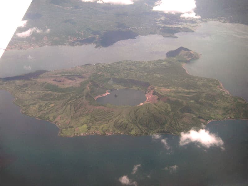
Banahaw is located in Philippines, within the Luzon Volcanic Arc of the broader Western Pacific Volcanic Regions. Situated at 14.07° N, 121.48° E in the Northern Hemisphere, the volcano lies within a tropical climate zone. At 2,158 meters above sea level, Banahaw rises above the surrounding terrain into montane or subalpine conditions. The elevation creates distinct ecological zones along its flanks, from forested lower slopes to exposed rocky terrain near the summit. The volcanic landform is characterized as a composite, which describes the physical shape and structure of the volcanic edifice as observed from the surface.
Geological Context
Banahaw sits in a subduction zone, where one tectonic plate dives beneath another, creating intense heat and pressure that generates magma. Subduction zones are responsible for many of the world's most explosive volcanoes and deadliest eruptions. For communities in Philippines near Banahaw, this tectonic setting means the volcano is capable of producing powerful explosive eruptions, pyroclastic flows, and lahars that can threaten populated areas within tens of kilometers of the summit. The dominant rock type is andesite / basaltic andesite, a dark, fine-grained volcanic rock that forms from rapidly cooling, low-viscosity lava. Basaltic eruptions tend to be less explosive and produce fluid lava flows that can travel long distances. While less immediately dangerous than explosive eruptions, basaltic lava flows can destroy structures and infrastructure in their path, and volcanic gases released during these eruptions can affect air quality over a wide area.
Eruption History Summary
Banahaw has 4 recorded eruptions in the geological database, spanning from 1730 CE to 1909 CE. These eruptions span roughly 179 years of volcanic history. The most recent eruption in 1909 CE places this volcano within the modern era of volcanological observation.
GVP Reference Summary
Banahaw (also known as Banahao), the highest of a group of volcanoes south and east of Manila, is flanked by San Cristobal (7 km W) and Banahaw de Lucban on the NE. Andesitic-to-dacitic lava domes occur on the flanks of both Banahaw and San Cristobal. Deposits from two major Holocene debris avalanches from Banahaw extend 13 km NE and 26 km SE, where it forms 10 km of the coastline of Tayabas Bay. The youthfule morphology of the San Cristobal stratovolcano suggests that it postdates Banahaw. Banahaw de Lucban stratovolcano was constructed within the 8-km-wide amphitheater related to the two debris avalanches, and is the youngest volcano of the Banahaw complex. The 2-km-wide, 600-m-deep summit crater of Banahaw is open to the SSW and contained a crater lake until 1730, when it drained, forming mudflows. Mudflows were also recorded in 1743?, 1843 and 1909, possibly also associated with explosive activity.
— Smithsonian Institution, Global Volcanism Program
4 Recorded Eruptions
| Year | VEI | Type | Area |
|---|---|---|---|
| 1909 | — | Uncertain Eruption | Banáhao |
| 1843 | — | Uncertain Eruption | Banáhao |
| 1743 | — | Uncertain Eruption | Banáhao |
| 1730 | — | Uncertain Eruption | Banáhao |
Real-Time Data
Frequently Asked Questions About Banahaw
Is Banahaw an active volcano?+
Banahaw is classified as active based on credible evidence of past eruptions. Although its last known eruption was in prehistoric times, volcanologists consider it capable of erupting again.
When did Banahaw last erupt?+
The most recent recorded eruption of Banahaw occurred in 1909 CE. The eruption was classified as a "Uncertain Eruption." Banahaw has 4 recorded eruptions in total.
How high is Banahaw?+
Banahaw has a summit elevation of 2,158 meters (7,080 feet) above sea level. At 2,158 meters, it is comparable in height to many significant mountain peaks and stands well above the tree line.
What type of volcano is Banahaw?+
Banahaw is classified as a Complex. Complex volcanoes have distinct geological characteristics that set them apart from other volcanic types.
Where is Banahaw located?+
Banahaw is located in Philippines, in the Western Pacific Volcanic Regions. More specifically, it lies within the Luzon Volcanic Arc. Its exact coordinates are 14.070° latitude, 121.480° longitude.
Is it safe to visit Banahaw?+
Banahaw can generally be visited, but as with any volcano, visitors should check local conditions and any advisory notices before traveling. Philippines may have specific regulations for accessing volcanic areas. Guided tours are often the safest and most informative way to experience a volcano.