About Moutohora Island
Moutohora Island is a complex rising to 352 meters (1,155 feet) in New Zealand's Tonga-Kermadec Volcanic Regions. No historical eruptions have been recorded, though the volcano is classified based on geological evidence of past activity.
Geography & Climate
Moutohora Island is located in New Zealand, within the Taupo Volcanic Arc of the broader Tonga-Kermadec Volcanic Regions. Situated at 37.85° S, 176.97° E in the Southern Hemisphere, the volcano lies within a temperate climate zone. At just 352 meters above sea level, Moutohora Island is a relatively low-elevation volcanic feature. Despite its modest height, it remains an active geological formation with the same underlying magmatic processes as its taller counterparts. The volcanic landform is characterized as a composite, which describes the physical shape and structure of the volcanic edifice as observed from the surface.
GVP Reference Summary
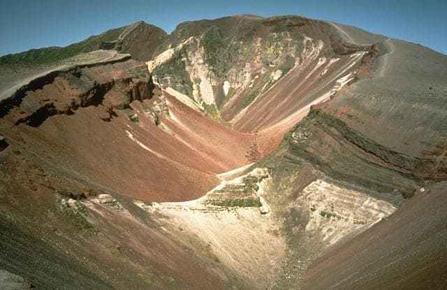
Moutohora (Whale) Island forms the summit of a largely submerged Pleistocene dacitic-andesitic complex volcano that lies 11 km offshore from Whakatane in the Bay of Plenty. The 2.5-km-long island includes a central dome complex flanked, by East Dome and Pa Hill lava dome, which forms the NW tip of the island. Acid hot springs, steaming ground, and fumaroles are present on the island. The central cone and east dome are both older than the roughly 42,000 before present (BP) Rotoehu Tephra, and Pa Hill dome is overlain by the 9,000 years BP Rotoma Ash, but may be considerably older. It was included in the Catalog of Active Volcanoes of the World (Nairn and Cole, 1975) based on its thermal activity.
— Smithsonian Institution, Global Volcanism Program
0 Recorded Eruptions
No eruption records available for Moutohora Island.
Real-Time Data
Frequently Asked Questions About Moutohora Island
Is Moutohora Island an active volcano?+
Moutohora Island is not currently classified as active. Its activity evidence is listed as "unknown." No recorded eruptions have been documented. However, no volcano is ever considered permanently extinct.
How high is Moutohora Island?+
Moutohora Island has a summit elevation of 352 meters (1,155 feet) above sea level. At 352 meters, it is a relatively low-elevation volcano.
What type of volcano is Moutohora Island?+
Moutohora Island is classified as a Complex. Complex volcanoes have distinct geological characteristics that set them apart from other volcanic types.
Where is Moutohora Island located?+
Moutohora Island is located in New Zealand, in the Tonga-Kermadec Volcanic Regions. More specifically, it lies within the Taupo Volcanic Arc. Its exact coordinates are -37.855° latitude, 176.974° longitude.
Is it safe to visit Moutohora Island?+
Moutohora Island can generally be visited, but as with any volcano, visitors should check local conditions and any advisory notices before traveling. New Zealand may have specific regulations for accessing volcanic areas. Guided tours are often the safest and most informative way to experience a volcano.