About Okataina
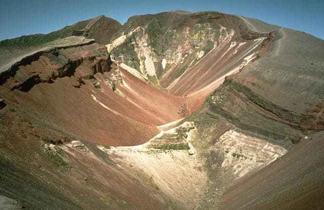
Okataina is a lava dome(s) rising to 1,111 meters (3,645 feet) in New Zealand's Tonga-Kermadec Volcanic Regions. It last erupted in 1981 CE, and volcanologists consider it an active volcanic system. The volcano has produced 20 recorded eruptions, with a maximum Volcanic Explosivity Index (VEI) of 1.
Geography & Climate
Okataina is located in New Zealand, within the Taupo Volcanic Arc of the broader Tonga-Kermadec Volcanic Regions. Situated at 38.16° S, 176.51° E in the Southern Hemisphere, the volcano lies within a temperate climate zone. With a summit elevation of 1,111 meters above sea level, Okataina is a moderately sized peak that remains accessible to hikers and researchers for much of the year. The volcanic landform is characterized as a cluster, which describes the physical shape and structure of the volcanic edifice as observed from the surface.
Geological Context
Okataina sits in a subduction zone, where one tectonic plate dives beneath another, creating intense heat and pressure that generates magma. Subduction zones are responsible for many of the world's most explosive volcanoes and deadliest eruptions. For communities in New Zealand near Okataina, this tectonic setting means the volcano is capable of producing powerful explosive eruptions, pyroclastic flows, and lahars that can threaten populated areas within tens of kilometers of the summit. The dominant rock type is rhyolite, a silica-rich volcanic rock associated with highly viscous magma. Rhyolitic eruptions can be extremely explosive and are responsible for some of the largest volcanic events in Earth's history, including supervolcanic caldera-forming eruptions. The high silica content traps dissolved gases, building enormous pressure that can lead to catastrophic explosive releases.
Eruption History Summary
Okataina has 20 recorded eruptions in the geological database, spanning from 1896 CE to 1981 CE. The most powerful recorded event was a gentle, effusive event in 1981 CE, reaching VEI 1 on the Volcanic Explosivity Index. With an average interval of roughly 4 years between eruptions over a span of 85 years, this is one of the more frequently active volcanoes in the database. This persistent activity suggests a robust and well-supplied magma system beneath the volcano. The most recent eruption in 1981 CE places this volcano within the modern era of volcanological observation.
Significance
Its 20 recorded eruptions make it one of the most prolific volcanoes in our database, reflecting a persistent and well-documented eruptive history that has provided volcanologists with extensive data for understanding eruption patterns and forecasting future activity. Given its recent activity, Okataina is closely monitored by geological survey organizations to provide early warning of future unrest.
GVP Reference Summary
The massive, dominantly rhyolitic Okataina Volcanic Centre (OVC) is surrounded by extensive ignimbrite and pyroclastic sheets produced during multiple caldera-forming eruptions. Numerous lava domes and craters erupted from two subparallel NE-SW-trending vent lineations form the Haroharo and Tarawera volcanic complexes. Lava domes of the Haroharo complex, at the northern end of the OVC, occupy part of the 16 x 26 km Pleistocene Haroharo caldera, which formed incrementally between 300,000 and 50,000 years before present (BP). The oldest exposed rocks on the caldera floor are about 22,000 years old. The Tarawera complex at the southern end of OVC consists of 11 rhyolitic lava domes and associated lava flows. The oldest domes were formed as late as about 15,000 years BP, and the youngest were formed in the Kaharoa eruption about 800 years BP. The NE-SW Tarawera vent lineation extends from the two dacitic cones of Maungaongaonga and Mangakakaramea on the SW to Mount Edgecumbe on the NE. Construction of the Haroharo and Tarawera complexes impounded lakes Rotoiti, Totoehu, Okataina, and Tarawera against the outer margins of the Okataina ring structure. A major hydrothermal area is located at Waimangu; the world-renowned Pink and White Terrace siliceous sinter deposits were destroyed during the major basaltic explosive eruption of 1886.
— Smithsonian Institution, Global Volcanism Program
20 Recorded Eruptions
| Year | VEI | Type | Area |
|---|---|---|---|
| 1981 | 1 | Confirmed Eruption | Waimangu (Raupo Pond crater) |
| 1978 | 1 | Confirmed Eruption | Waimangu (Raupo Pond, Inferno Crater) |
| 1973 | 1 | Confirmed Eruption | Waimangu (Echo Crater) |
| 1951 | 1 | Confirmed Eruption | Rotomahana |
| 1926 | 1 | Confirmed Eruption | Rotomahana |
| 1924 | 1 | Confirmed Eruption | Waimangu (Echo Crater) |
| 1918 | 1 | Confirmed Eruption | Waimangu (Echo Crater) |
| 1917 | 1 | Confirmed Eruption | Waimangu (Echo Crater) |
| 1915 | 1 | Confirmed Eruption | Waimangu (Echo Crater & NW of Fairy Crater) |
| 1915 | 1 | Confirmed Eruption | Waimangu (Echo Crater) |
| 1914 | 1 | Confirmed Eruption | Waimangu (NW of Fairy Crater) |
| 1913 | 1 | Confirmed Eruption | Waimangu (Echo Crater) |
| 1912 | 1 | Confirmed Eruption | Waimangu (Echo Crater) |
| 1910 | 1 | Confirmed Eruption | Waimangu (Echo Crater) |
| 1908 | 1 | Confirmed Eruption | Waimangu (Echo Crater) |
| 1906 | 1 | Confirmed Eruption | Waimangu (NW of Fairy Crater) |
| 1905 | 1 | Confirmed Eruption | Waimangu (Echo Crater) |
| 1905 | 1 | Confirmed Eruption | Waimangu (Echo Crater) |
| 1900 | 1 | Confirmed Eruption | Waimangu Geyser |
| 1896 | 1 | Confirmed Eruption | Waimangu (Echo Crater) |
Real-Time Data
Frequently Asked Questions About Okataina
Is Okataina an active volcano?+
Yes, Okataina is considered an active volcano. Its most recent eruption was in 1981 CE. The volcano is monitored by geological agencies, and its activity status is based on observed eruptions within recorded history.
When did Okataina last erupt?+
The most recent recorded eruption of Okataina occurred in 1981 CE with a Volcanic Explosivity Index (VEI) of 1. The eruption was classified as a "Confirmed Eruption." Okataina has 20 recorded eruptions in total.
How high is Okataina?+
Okataina has a summit elevation of 1,111 meters (3,645 feet) above sea level. At 1,111 meters, it is a moderately sized volcanic peak, roughly comparable to Mount Vesuvius (1,281m).
What type of volcano is Okataina?+
Okataina is classified as a Lava dome(s). Lava domes are mounds of viscous lava that pile up around a volcanic vent. They grow by expansion from within and can collapse to produce dangerous pyroclastic flows.
Where is Okataina located?+
Okataina is located in New Zealand, in the Tonga-Kermadec Volcanic Regions. More specifically, it lies within the Taupo Volcanic Arc. Its exact coordinates are -38.157° latitude, 176.507° longitude.
Is it safe to visit Okataina?+
Visiting Okataina requires checking current volcanic activity and alert levels. As an active volcano with eruptions as recent as 1981 CE, conditions can change rapidly. Always consult local geological authorities and follow official warnings before visiting. Many active volcanoes have designated safe viewing areas and guided tour options.