About Rotorua
Rotorua is a caldera rising to 757 meters (2,484 feet) in New Zealand's Tonga-Kermadec Volcanic Regions. No historical eruptions have been recorded, though the volcano is classified based on geological evidence of past activity.
Geography & Climate
Rotorua is located in New Zealand, within the Taupo Volcanic Arc of the broader Tonga-Kermadec Volcanic Regions. Situated at 38.08° S, 176.27° E in the Southern Hemisphere, the volcano lies within a temperate climate zone. With a summit elevation of 757 meters above sea level, Rotorua is a moderately sized peak that remains accessible to hikers and researchers for much of the year. The volcanic landform is characterized as a caldera, which describes the physical shape and structure of the volcanic edifice as observed from the surface.
GVP Reference Summary
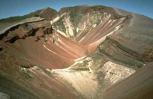
The 22-km-wide Rotorua caldera is the NW-most caldera of the Taupo volcanic zone. It is the only single-event caldera in the Taupo Volcanic Zone and was formed about 220,000 years ago following eruption of the more than 340 km3 rhyolitic Mamaku Ignimbrite. Although caldera collapse occurred in a single event, the process was complex and involved multiple collapse blocks. The major city of Rotorua lies at the south end of the lake that fills much of the caldera. Post-collapse eruptive activity, which ceased during the Pleistocene, was restricted to lava dome extrusion without major explosive activity. The youngest activity consisted of the eruption of three lava domes less than 25,000 years ago. The major thermal areas of Takeke, Tikitere, Lake Rotokawa, and Rotorua-Whakarewarewa are located within the caldera or outside its rim, and the city of Rotorua lies within and adjacent to active geothermal fields.
— Smithsonian Institution, Global Volcanism Program
0 Recorded Eruptions
No eruption records available for Rotorua.
Real-Time Data
Frequently Asked Questions About Rotorua
Is Rotorua an active volcano?+
Rotorua is not currently classified as active. Its activity evidence is listed as "unknown." No recorded eruptions have been documented. However, no volcano is ever considered permanently extinct.
How high is Rotorua?+
Rotorua has a summit elevation of 757 meters (2,484 feet) above sea level. At 757 meters, it is a relatively low-elevation volcano.
What type of volcano is Rotorua?+
Rotorua is classified as a Caldera. Calderas are large volcanic depressions formed when a volcano erupts so powerfully that its magma chamber collapses, creating a basin that can be kilometers wide. They are often sites of some of Earth's largest eruptions.
Where is Rotorua located?+
Rotorua is located in New Zealand, in the Tonga-Kermadec Volcanic Regions. More specifically, it lies within the Taupo Volcanic Arc. Its exact coordinates are -38.080° latitude, 176.270° longitude.
Is it safe to visit Rotorua?+
Rotorua can generally be visited, but as with any volcano, visitors should check local conditions and any advisory notices before traveling. New Zealand may have specific regulations for accessing volcanic areas. Guided tours are often the safest and most informative way to experience a volcano.