About Sergief
Sergief is a stratovolcano rising to 560 meters (1,837 feet) in United States's North America Volcanic Regions. No historical eruptions have been recorded, though the volcano is classified based on geological evidence of past activity.
Geography & Climate
Sergief is located in United States, within the Aleutian Ridge Volcanic Arc of the broader North America Volcanic Regions. Situated at 52.05° N, 174.95° W in the Northern Hemisphere, the volcano lies within a temperate climate zone. With a summit elevation of 560 meters above sea level, Sergief is a moderately sized peak that remains accessible to hikers and researchers for much of the year. The volcanic landform is characterized as a composite, which describes the physical shape and structure of the volcanic edifice as observed from the surface.
GVP Reference Summary
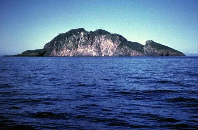
Sergief is a small stratovolcano on SW Atka Island whose age is poorly known. The SW part of the island is older and less topographically rugged than the NE part of the island. It was tentatively listed as a young volcano in the Post-Miocene Volcanoes of the World catalog of the International Association of Volcanology and Chemistry of the Earth's Interior (1973), but the age of its latest eruption is not precisely known.
— Smithsonian Institution, Global Volcanism Program
0 Recorded Eruptions
No eruption records available for Sergief.
Real-Time Data
Frequently Asked Questions About Sergief
Is Sergief an active volcano?+
Sergief is not currently classified as active. Its activity evidence is listed as "unknown." No recorded eruptions have been documented. However, no volcano is ever considered permanently extinct.
How high is Sergief?+
Sergief has a summit elevation of 560 meters (1,837 feet) above sea level. At 560 meters, it is a relatively low-elevation volcano.
What type of volcano is Sergief?+
Sergief is classified as a Stratovolcano. Stratovolcanoes (also called composite volcanoes) are steep, conical volcanoes built up by many layers of hardened lava, tephra, and volcanic ash. They are among the most common and dangerous types, known for explosive eruptions.
Where is Sergief located?+
Sergief is located in United States, in the North America Volcanic Regions. More specifically, it lies within the Aleutian Ridge Volcanic Arc. Its exact coordinates are 52.050° latitude, -174.950° longitude.
Is it safe to visit Sergief?+
Sergief can generally be visited, but as with any volcano, visitors should check local conditions and any advisory notices before traveling. United States may have specific regulations for accessing volcanic areas. Guided tours are often the safest and most informative way to experience a volcano.