About Kasatochi
Kasatochi is a stratovolcano rising to 314 meters (1,030 feet) in United States's North America Volcanic Regions. It has been active in recent decades, with its last eruption in 2008 CE. The volcano has produced 5 recorded eruptions, with a maximum Volcanic Explosivity Index (VEI) of 4.
Geography & Climate
Kasatochi is located in United States, within the Aleutian Ridge Volcanic Arc of the broader North America Volcanic Regions. Situated at 52.18° N, 175.51° W in the Northern Hemisphere, the volcano lies within a temperate climate zone. At just 314 meters above sea level, Kasatochi is a relatively low-elevation volcanic feature. Despite its modest height, it remains an active geological formation with the same underlying magmatic processes as its taller counterparts. The volcanic landform is characterized as a composite, which describes the physical shape and structure of the volcanic edifice as observed from the surface.
Geological Context
Kasatochi sits in a subduction zone, where one tectonic plate dives beneath another, creating intense heat and pressure that generates magma. Subduction zones are responsible for many of the world's most explosive volcanoes and deadliest eruptions. For communities in United States near Kasatochi, this tectonic setting means the volcano is capable of producing powerful explosive eruptions, pyroclastic flows, and lahars that can threaten populated areas within tens of kilometers of the summit. The dominant rock type is basalt / picro-basalt, a dark, fine-grained volcanic rock that forms from rapidly cooling, low-viscosity lava. Basaltic eruptions tend to be less explosive and produce fluid lava flows that can travel long distances. While less immediately dangerous than explosive eruptions, basaltic lava flows can destroy structures and infrastructure in their path, and volcanic gases released during these eruptions can affect air quality over a wide area.
Eruption History Summary
Kasatochi has 5 recorded eruptions in the geological database, spanning from 1760 CE to 2008 CE. The most powerful recorded event was a cataclysmic eruption with ash columns reaching the stratosphere in 2008 CE, reaching VEI 4 on the Volcanic Explosivity Index. This eruption frequency indicates a moderately active volcanic system with periodic reawakenings. With eruptive activity as recently as 2008 CE, Kasatochi remains an actively monitored volcano.
Significance
With a maximum recorded VEI of 4, Kasatochi has demonstrated the capacity for significant explosive eruptions that can impact regional aviation, agriculture, and communities tens of kilometers from the summit. VEI 4 eruptions produce ash columns reaching 15-25 kilometers into the atmosphere. With 5 recorded eruptions on file, Kasatochi has enough documented activity to help scientists identify patterns in its eruptive behavior. Given its recent activity, Kasatochi is closely monitored by geological survey organizations to provide early warning of future unrest.
GVP Reference Summary
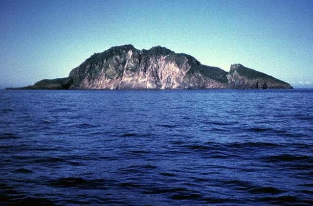
Located at the northern end of a shallow submarine ridge trending perpendicular to the Aleutian arc, Kasatochi is small 2.7 x 3.3 km island volcano with a 750-m-wide summit crater lake. The summit reaches only about 300 m elevation, and the lake surface lies less than about 60 m above the sea. A lava dome is located on the NW flank at about 150 m elevation. The asymmetrical island is steeper on the northern side than the southern, and the crater lies north of the center of the island. Reports of activity from the heavily eroded Koniuji volcano to the east probably refer to eruptions from Kasatochi. A lava flow may have been emplaced during the first recorded eruption in 1760. A major explosive eruption in 2008 produced pyroclastic flows and surges that swept into the sea, extending the island's shoreline.
— Smithsonian Institution, Global Volcanism Program
5 Recorded Eruptions
| Year | VEI | Type | Area |
|---|---|---|---|
| 2008 | 4 | Confirmed Eruption | — |
| 1899 | — | Uncertain Eruption | — |
| 1828 | — | Uncertain Eruption | — |
| 1827 | — | Uncertain Eruption | — |
| 1760 | 0 | Confirmed Eruption | — |
Real-Time Data
Frequently Asked Questions About Kasatochi
Is Kasatochi an active volcano?+
Yes, Kasatochi is considered an active volcano. Its most recent eruption was in 2008 CE. The volcano is monitored by geological agencies, and its activity status is based on observed eruptions within recorded history.
When did Kasatochi last erupt?+
The most recent recorded eruption of Kasatochi occurred in 2008 CE with a Volcanic Explosivity Index (VEI) of 4. The eruption was classified as a "Confirmed Eruption." Kasatochi has 5 recorded eruptions in total.
How high is Kasatochi?+
Kasatochi has a summit elevation of 314 meters (1,030 feet) above sea level. At 314 meters, it is a relatively low-elevation volcano.
What type of volcano is Kasatochi?+
Kasatochi is classified as a Stratovolcano. Stratovolcanoes (also called composite volcanoes) are steep, conical volcanoes built up by many layers of hardened lava, tephra, and volcanic ash. They are among the most common and dangerous types, known for explosive eruptions.
Where is Kasatochi located?+
Kasatochi is located in United States, in the North America Volcanic Regions. More specifically, it lies within the Aleutian Ridge Volcanic Arc. Its exact coordinates are 52.177° latitude, -175.508° longitude.
Is it safe to visit Kasatochi?+
Visiting Kasatochi requires checking current volcanic activity and alert levels. As an active volcano with eruptions as recent as 2008 CE, conditions can change rapidly. Always consult local geological authorities and follow official warnings before visiting. Many active volcanoes have designated safe viewing areas and guided tour options.