About Koniuji
Koniuji is a stratovolcano rising to 273 meters (896 feet) in United States's North America Volcanic Regions. Its last known eruption dates to 1150 BCE, in prehistoric times. The volcano has produced 3 recorded eruptions.
Geography & Climate
Koniuji is located in United States, within the Aleutian Ridge Volcanic Arc of the broader North America Volcanic Regions. Situated at 52.22° N, 175.13° W in the Northern Hemisphere, the volcano lies within a temperate climate zone. At just 273 meters above sea level, Koniuji is a relatively low-elevation volcanic feature. Despite its modest height, it remains an active geological formation with the same underlying magmatic processes as its taller counterparts. The volcanic landform is characterized as a composite, which describes the physical shape and structure of the volcanic edifice as observed from the surface.
Geological Context
Koniuji sits in a subduction zone, where one tectonic plate dives beneath another, creating intense heat and pressure that generates magma. Subduction zones are responsible for many of the world's most explosive volcanoes and deadliest eruptions. For communities in United States near Koniuji, this tectonic setting means the volcano is capable of producing powerful explosive eruptions, pyroclastic flows, and lahars that can threaten populated areas within tens of kilometers of the summit. The dominant rock type is andesite / basaltic andesite, a dark, fine-grained volcanic rock that forms from rapidly cooling, low-viscosity lava. Basaltic eruptions tend to be less explosive and produce fluid lava flows that can travel long distances. While less immediately dangerous than explosive eruptions, basaltic lava flows can destroy structures and infrastructure in their path, and volcanic gases released during these eruptions can affect air quality over a wide area.
Eruption History Summary
Koniuji has 3 recorded eruptions in the geological database, spanning from 3850 BCE to 1150 BCE. These eruptions span roughly 2,700 years of volcanic history.
GVP Reference Summary
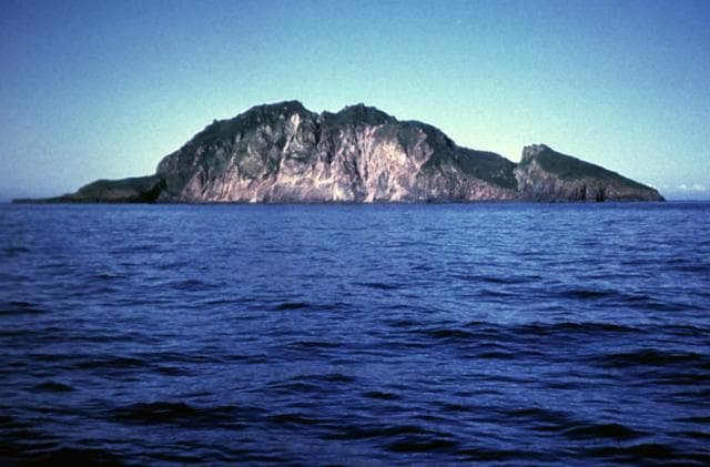
The very small, 1 x 1.5 km Koniuji Island, between Atka and Kasatochi volcanoes, is the emergent top of a mostly submarine volcano. Located about 20 km N of the western side of Atka Island, the volcano is deeply dissected, with a steep, arcuate cliff on the west. New Ar-Ar dating indicates that the island emerged above sea level aout 15,000 years ago, and that several lava flows and domes were erupted during the Holocene. The summit lava dome is younger than about 3,000 years. Reports of historical eruptive activity may be erroneous and are considered to refer to eruptions of the relatively undissected Kasatochi, 25 km W.
— Smithsonian Institution, Global Volcanism Program
3 Recorded Eruptions
| Year | VEI | Type | Area |
|---|---|---|---|
| 1150 BCE | — | Confirmed Eruption | — |
| 2650 BCE | — | Confirmed Eruption | — |
| 3850 BCE | — | Confirmed Eruption | — |
Real-Time Data
Frequently Asked Questions About Koniuji
Is Koniuji an active volcano?+
Koniuji is not currently classified as active. Its activity evidence is listed as "Eruption Dated." The last known eruption was in 1150 BCE. However, no volcano is ever considered permanently extinct.
When did Koniuji last erupt?+
The most recent recorded eruption of Koniuji occurred in 1150 BCE. The eruption was classified as a "Confirmed Eruption." Koniuji has 3 recorded eruptions in total.
How high is Koniuji?+
Koniuji has a summit elevation of 273 meters (896 feet) above sea level. At 273 meters, it is a relatively low-elevation volcano.
What type of volcano is Koniuji?+
Koniuji is classified as a Stratovolcano. Stratovolcanoes (also called composite volcanoes) are steep, conical volcanoes built up by many layers of hardened lava, tephra, and volcanic ash. They are among the most common and dangerous types, known for explosive eruptions.
Where is Koniuji located?+
Koniuji is located in United States, in the North America Volcanic Regions. More specifically, it lies within the Aleutian Ridge Volcanic Arc. Its exact coordinates are 52.220° latitude, -175.130° longitude.
Is it safe to visit Koniuji?+
Koniuji can generally be visited, but as with any volcano, visitors should check local conditions and any advisory notices before traveling. United States may have specific regulations for accessing volcanic areas. Guided tours are often the safest and most informative way to experience a volcano.


