About Adagdak
Adagdak is a stratovolcano rising to 610 meters (2,001 feet) in United States's North America Volcanic Regions. No historical eruptions have been recorded, though the volcano is classified based on geological evidence of past activity.
Geography & Climate
Adagdak is located in United States, within the Aleutian Ridge Volcanic Arc of the broader North America Volcanic Regions. Situated at 51.99° N, 176.59° W in the Northern Hemisphere, the volcano lies within a temperate climate zone. With a summit elevation of 610 meters above sea level, Adagdak is a moderately sized peak that remains accessible to hikers and researchers for much of the year. The volcanic landform is characterized as a composite, which describes the physical shape and structure of the volcanic edifice as observed from the surface.
GVP Reference Summary
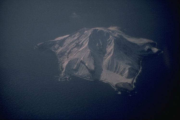
Mount Adagdak, at the NE tip of Adak Island, lies across Andrew Lagoon from Mount Moffett volcano and about 15 km NNE of Adak, the largest town of the Aleutians. It consists of a small stratovolcano capping an older shield volcano exposed on the southern side of the complex. An andesitic lava dome fills the summit crater. A late-stage basaltic lava dome was constructed on the SE flank, and a phreatic vent is located on the W flank of the shield volcano. The most recent eruptions are thought to be Holocene (Marsh, in Wood and Kienle 1990) or Pleistocene (Motyka et al. 1993, Nye et al. 1998). Three stages of volcanism were mapped by Bratten, the youngest of which was a lava dome dated at about 0.21 million years (AVO, 2005-). The older Andrew Bay volcano, located north of Andrew Lagoon between Adagdak and Moffett volcanoes, is preserved only in erosional remnants. Andrew Bay Hot Springs lie along the coast west of Mount Adagdak, and the northern part of Adak Island has been investigated for geothermal power potential.
— Smithsonian Institution, Global Volcanism Program
0 Recorded Eruptions
No eruption records available for Adagdak.
Real-Time Data
Frequently Asked Questions About Adagdak
Is Adagdak an active volcano?+
Adagdak is not currently classified as active. Its activity evidence is listed as "unknown." No recorded eruptions have been documented. However, no volcano is ever considered permanently extinct.
How high is Adagdak?+
Adagdak has a summit elevation of 610 meters (2,001 feet) above sea level. At 610 meters, it is a relatively low-elevation volcano.
What type of volcano is Adagdak?+
Adagdak is classified as a Stratovolcano. Stratovolcanoes (also called composite volcanoes) are steep, conical volcanoes built up by many layers of hardened lava, tephra, and volcanic ash. They are among the most common and dangerous types, known for explosive eruptions.
Where is Adagdak located?+
Adagdak is located in United States, in the North America Volcanic Regions. More specifically, it lies within the Aleutian Ridge Volcanic Arc. Its exact coordinates are 51.988° latitude, -176.592° longitude.
Is it safe to visit Adagdak?+
Adagdak can generally be visited, but as with any volcano, visitors should check local conditions and any advisory notices before traveling. United States may have specific regulations for accessing volcanic areas. Guided tours are often the safest and most informative way to experience a volcano.