About Apoyeque
Apoyeque is a caldera rising to 518 meters (1,700 feet) in Nicaragua's Middle America-Caribbean Volcanic Regions. Its last known eruption dates to 50 BCE, in prehistoric times. The volcano has produced 4 recorded eruptions, with a maximum Volcanic Explosivity Index (VEI) of 6.
Geography & Climate
Apoyeque is located in Nicaragua, within the Central America Volcanic Arc of the broader Middle America-Caribbean Volcanic Regions. Situated at 12.24° N, 86.34° W in the Northern Hemisphere, the volcano lies within a tropical climate zone. With a summit elevation of 518 meters above sea level, Apoyeque is a moderately sized peak that remains accessible to hikers and researchers for much of the year. The volcanic landform is characterized as a caldera, which describes the physical shape and structure of the volcanic edifice as observed from the surface.
Geological Context
Apoyeque sits in a subduction zone, where one tectonic plate dives beneath another, creating intense heat and pressure that generates magma. Subduction zones are responsible for many of the world's most explosive volcanoes and deadliest eruptions. For communities in Nicaragua near Apoyeque, this tectonic setting means the volcano is capable of producing powerful explosive eruptions, pyroclastic flows, and lahars that can threaten populated areas within tens of kilometers of the summit. The dominant rock type is dacite, an intermediate to silica-rich volcanic rock. This composition typically produces more viscous magma, leading to more explosive eruptions with ash columns and pyroclastic flows. Andesitic and dacitic magmas build pressure before erupting, which is why volcanoes with this rock chemistry are often associated with Plinian-style eruptions that can send ash tens of kilometers into the atmosphere and disrupt aviation across entire regions.
Eruption History Summary
Apoyeque has 4 recorded eruptions in the geological database, spanning from 4160 BCE to 50 BCE. The most powerful recorded event was a colossal eruption capable of affecting global climate for years in 50 BCE, reaching VEI 6 on the Volcanic Explosivity Index. Notable eruptions include 50 BCE (VEI 6), 1050 BCE (VEI 4), 2550 BCE (VEI 5). These eruptions span roughly 4,110 years of volcanic history.
Significance
Apoyeque has produced at least one eruption of VEI 6 or higher, placing it among the most powerful volcanic systems on Earth. Eruptions of this magnitude inject massive quantities of sulfur dioxide into the stratosphere, affecting global climate by lowering average temperatures for one to three years after the event.
GVP Reference Summary
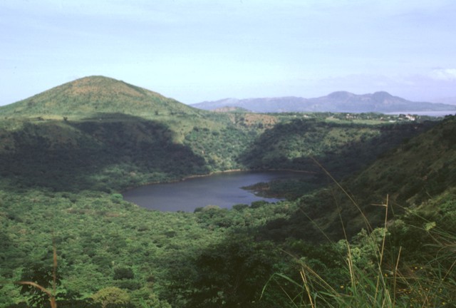
The Apoyeque volcanic complex occupies the broad Chiltepe Peninsula, which extends into south-central Lake Managua. The peninsula is part of the Chiltepe pyroclastic shield volcano, one of three large ignimbrite shields on the Nicaraguan volcanic front. A 2.8-km wide, 400-m-deep, lake-filled caldera whose floor lies near sea level truncates the low Apoyeque edifice, which rises only about 500 m above the lake shore. The caldera was the source of a thick deposit of dacitic pumice that covers the surrounding area. The 2.5 x 3 km lake-filled Xiloá (Jiloá) maar is located immediately SE of Apoyeque. The Talpetatl lava dome was constructed between Laguna Xiloá and Lake Managua. Pumiceous pyroclastic flows from Laguna Xiloá were erupted about 6,100 years ago and overlie deposits of comparable age from the Masaya Plinian eruption.
— Smithsonian Institution, Global Volcanism Program
4 Recorded Eruptions
| Year | VEI | Type | Area |
|---|---|---|---|
| 50 BCE | 6 | Confirmed Eruption | Apoyeque |
| 1050 BCE | 4 | Confirmed Eruption | — |
| 2550 BCE | 5 | Confirmed Eruption | W Chiltepe Peninsula |
| 4160 BCE | 5 | Confirmed Eruption | Laguna Xiloá |
Real-Time Data
Frequently Asked Questions About Apoyeque
Is Apoyeque an active volcano?+
Apoyeque is not currently classified as active. Its activity evidence is listed as "Eruption Dated." The last known eruption was in 50 BCE. However, no volcano is ever considered permanently extinct.
When did Apoyeque last erupt?+
The most recent recorded eruption of Apoyeque occurred in 50 BCE with a Volcanic Explosivity Index (VEI) of 6. The eruption was classified as a "Confirmed Eruption." Apoyeque has 4 recorded eruptions in total.
How high is Apoyeque?+
Apoyeque has a summit elevation of 518 meters (1,700 feet) above sea level. At 518 meters, it is a relatively low-elevation volcano.
What type of volcano is Apoyeque?+
Apoyeque is classified as a Caldera. Calderas are large volcanic depressions formed when a volcano erupts so powerfully that its magma chamber collapses, creating a basin that can be kilometers wide. They are often sites of some of Earth's largest eruptions.
Where is Apoyeque located?+
Apoyeque is located in Nicaragua, in the Middle America-Caribbean Volcanic Regions. More specifically, it lies within the Central America Volcanic Arc. Its exact coordinates are 12.242° latitude, -86.342° longitude.
Is it safe to visit Apoyeque?+
Apoyeque can generally be visited, but as with any volcano, visitors should check local conditions and any advisory notices before traveling. Nicaragua may have specific regulations for accessing volcanic areas. Guided tours are often the safest and most informative way to experience a volcano.