About Momotombo
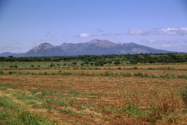
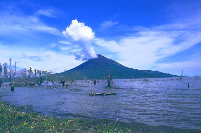
Momotombo is a stratovolcano rising to 1,270 meters (4,167 feet) in Nicaragua's Middle America-Caribbean Volcanic Regions. It has been active in recent decades, with its last eruption in 2016 CE. The volcano has produced 20 recorded eruptions, with a maximum Volcanic Explosivity Index (VEI) of 4.
Geography & Climate
Momotombo is located in Nicaragua, within the Central America Volcanic Arc of the broader Middle America-Caribbean Volcanic Regions. Situated at 12.42° N, 86.54° W in the Northern Hemisphere, the volcano lies within a tropical climate zone. With a summit elevation of 1,270 meters above sea level, Momotombo is a moderately sized peak that remains accessible to hikers and researchers for much of the year. The volcanic landform is characterized as a composite, which describes the physical shape and structure of the volcanic edifice as observed from the surface.
Geological Context
Momotombo sits in a subduction zone, where one tectonic plate dives beneath another, creating intense heat and pressure that generates magma. Subduction zones are responsible for many of the world's most explosive volcanoes and deadliest eruptions. For communities in Nicaragua near Momotombo, this tectonic setting means the volcano is capable of producing powerful explosive eruptions, pyroclastic flows, and lahars that can threaten populated areas within tens of kilometers of the summit. The dominant rock type is basalt / picro-basalt, a dark, fine-grained volcanic rock that forms from rapidly cooling, low-viscosity lava. Basaltic eruptions tend to be less explosive and produce fluid lava flows that can travel long distances. While less immediately dangerous than explosive eruptions, basaltic lava flows can destroy structures and infrastructure in their path, and volcanic gases released during these eruptions can affect air quality over a wide area.
Eruption History Summary
Momotombo has 20 recorded eruptions in the geological database, spanning from 1100 CE to 2015 CE. The most powerful recorded event was a cataclysmic eruption with ash columns reaching the stratosphere in 1605 CE, reaching VEI 4 on the Volcanic Explosivity Index. Notable eruptions include 1605 CE (VEI 4), 1524 CE (VEI 3). With an average interval of roughly 46 years between eruptions over a span of 915 years, this is one of the more frequently active volcanoes in the database. This persistent activity suggests a robust and well-supplied magma system beneath the volcano. With eruptive activity as recently as 2015 CE, Momotombo remains an actively monitored volcano.
Significance
With a maximum recorded VEI of 4, Momotombo has demonstrated the capacity for significant explosive eruptions that can impact regional aviation, agriculture, and communities tens of kilometers from the summit. VEI 4 eruptions produce ash columns reaching 15-25 kilometers into the atmosphere. Its 20 recorded eruptions make it one of the most prolific volcanoes in our database, reflecting a persistent and well-documented eruptive history that has provided volcanologists with extensive data for understanding eruption patterns and forecasting future activity. Given its recent activity, Momotombo is closely monitored by geological survey organizations to provide early warning of future unrest.
GVP Reference Summary
Momotombo is a young stratovolcano that rises prominently above the NW shore of Lake Managua, forming one of Nicaragua's most familiar landmarks. Momotombo began growing about 4500 years ago at the SE end of the Marrabios Range and consists of a somma from an older edifice that is surmounted by a symmetrical younger cone with a 150 x 250 m wide summit crater. Young lava flows extend down the NW flank into the 4-km-wide Monte Galán caldera. The youthful cone of Momotombito forms an island offshore in Lake Managua. Momotombo has a long record of Strombolian eruptions, punctuated by occasional stronger explosive activity. The latest eruption, in 1905, produced a lava flow that traveled from the summit to the lower NE base. A small black plume was seen above the crater after a 10 April 1996 earthquake, but later observations noted no significant changes in the crater. A major geothermal field is located on the south flank.
— Smithsonian Institution, Global Volcanism Program
20 Recorded Eruptions
| Year | VEI | Type | Area |
|---|---|---|---|
| 2015 | 2 | Confirmed Eruption | Summit crater and NW flank |
| 1918 | 1 | Uncertain Eruption | — |
| 1905 | 2 | Confirmed Eruption | — |
| 1902 | 2 | Confirmed Eruption | — |
| 1886 | 2 | Confirmed Eruption | — |
| 1885 | 1 | Uncertain Eruption | — |
| 1882 | 2 | Confirmed Eruption | — |
| 1878 | 2 | Confirmed Eruption | — |
| 1870 | 2 | Confirmed Eruption | — |
| 1858 | 2 | Confirmed Eruption | — |
| 1854 | 2 | Confirmed Eruption | — |
| 1852 | 2 | Confirmed Eruption | — |
| 1849 | 2 | Confirmed Eruption | — |
| 1764 | 2 | Confirmed Eruption | — |
| 1736 | 2 | Confirmed Eruption | — |
| 1609 | — | Uncertain Eruption | — |
| 1605 | 4 | Confirmed Eruption | — |
| 1578 | 2 | Confirmed Eruption | — |
| 1524 | 3 | Confirmed Eruption | — |
| 1100 | — | Confirmed Eruption | — |
Real-Time Data
Frequently Asked Questions About Momotombo
Is Momotombo an active volcano?+
Yes, Momotombo is considered an active volcano. Its most recent eruption was in 2016 CE. The volcano is monitored by geological agencies, and its activity status is based on observed eruptions within recorded history.
When did Momotombo last erupt?+
The most recent recorded eruption of Momotombo occurred in 2015 CE with a Volcanic Explosivity Index (VEI) of 2. The eruption was classified as a "Confirmed Eruption." Momotombo has 20 recorded eruptions in total.
How high is Momotombo?+
Momotombo has a summit elevation of 1,270 meters (4,167 feet) above sea level. At 1,270 meters, it is a moderately sized volcanic peak, roughly comparable to Mount Vesuvius (1,281m).
What type of volcano is Momotombo?+
Momotombo is classified as a Stratovolcano. Stratovolcanoes (also called composite volcanoes) are steep, conical volcanoes built up by many layers of hardened lava, tephra, and volcanic ash. They are among the most common and dangerous types, known for explosive eruptions.
Where is Momotombo located?+
Momotombo is located in Nicaragua, in the Middle America-Caribbean Volcanic Regions. More specifically, it lies within the Central America Volcanic Arc. Its exact coordinates are 12.423° latitude, -86.539° longitude.
Is it safe to visit Momotombo?+
Visiting Momotombo requires checking current volcanic activity and alert levels. As an active volcano with eruptions as recent as 2016 CE, conditions can change rapidly. Always consult local geological authorities and follow official warnings before visiting. Many active volcanoes have designated safe viewing areas and guided tour options.