About Tuhua/Mayor Island
Tuhua/Mayor Island is a shield rising to 355 meters (1,165 feet) in New Zealand's Tonga-Kermadec Volcanic Regions. The volcano is currently active, with its most recent eruption in 5055 BCE. The volcano has produced 2 recorded eruptions, with a maximum Volcanic Explosivity Index (VEI) of 5.
Geography & Climate
Tuhua/Mayor Island is located in New Zealand, within the Taupo Volcanic Arc of the broader Tonga-Kermadec Volcanic Regions. Situated at 37.28° S, 176.25° E in the Southern Hemisphere, the volcano lies within a temperate climate zone. At just 355 meters above sea level, Tuhua/Mayor Island is a relatively low-elevation volcanic feature. Despite its modest height, it remains an active geological formation with the same underlying magmatic processes as its taller counterparts. The volcanic landform is characterized as a shield, which describes the physical shape and structure of the volcanic edifice as observed from the surface.
Geological Context
Tuhua/Mayor Island sits in a subduction zone, where one tectonic plate dives beneath another, creating intense heat and pressure that generates magma. Subduction zones are responsible for many of the world's most explosive volcanoes and deadliest eruptions. For communities in New Zealand near Tuhua/Mayor Island, this tectonic setting means the volcano is capable of producing powerful explosive eruptions, pyroclastic flows, and lahars that can threaten populated areas within tens of kilometers of the summit. The dominant rock type is rhyolite, a silica-rich volcanic rock associated with highly viscous magma. Rhyolitic eruptions can be extremely explosive and are responsible for some of the largest volcanic events in Earth's history, including supervolcanic caldera-forming eruptions. The high silica content traps dissolved gases, building enormous pressure that can lead to catastrophic explosive releases.
Eruption History Summary
Tuhua/Mayor Island has 2 recorded eruptions in the geological database, spanning from 6050 BCE to 5055 BCE. The most powerful recorded event was a paroxysmal eruption with devastating regional consequences in 5055 BCE, reaching VEI 5 on the Volcanic Explosivity Index. These eruptions span roughly 995 years of volcanic history.
Significance
With a maximum recorded VEI of 5, Tuhua/Mayor Island has demonstrated the capacity for paroxysmal eruptions comparable to the 1980 eruption of Mount St. Helens. Eruptions of this scale can devastate areas within 20-30 kilometers and produce ash fall that disrupts aviation and agriculture across hundreds of kilometers.
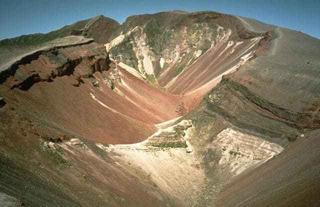
GVP Reference Summary
The 4-km-wide Tuhua/Mayor Island, offshore of North Island in the Bay of Plenty, is the emergent portion of a 15-km-wide peralkaline shield volcano constructed between about 120,000 and 35,000 years ago. A 3-km-wide composite caldera was formed in two or three collapse events, the last of which took place about 6,300 years ago, and was accompanied by a Plinian eruption that produced tephra deposits up to 70 cm thick on the mainland. Post-caldera eruptions generated a series of lava domes and flows emplaced from NNE-trending vents within the caldera that have filled it to depths of at least 180 m. The latest eruption has not been dated, but was considered by Houghton et al. (1992) to have occurred perhaps only 500-1,000 years ago.
— Smithsonian Institution, Global Volcanism Program
2 Recorded Eruptions
| Year | VEI | Type | Area |
|---|---|---|---|
| 5055 BCE | 5 | Confirmed Eruption | South end of caldera, Taratimi Bay |
| 6050 BCE | — | Confirmed Eruption | SE caldera rim |
Real-Time Data
Frequently Asked Questions About Tuhua/Mayor Island
Is Tuhua/Mayor Island an active volcano?+
Tuhua/Mayor Island is not currently classified as active. Its activity evidence is listed as "Eruption Dated." The last known eruption was in 5055 BCE. However, no volcano is ever considered permanently extinct.
When did Tuhua/Mayor Island last erupt?+
The most recent recorded eruption of Tuhua/Mayor Island occurred in 5055 BCE with a Volcanic Explosivity Index (VEI) of 5. The eruption was classified as a "Confirmed Eruption." Tuhua/Mayor Island has 2 recorded eruptions in total.
How high is Tuhua/Mayor Island?+
Tuhua/Mayor Island has a summit elevation of 355 meters (1,165 feet) above sea level. At 355 meters, it is a relatively low-elevation volcano.
What type of volcano is Tuhua/Mayor Island?+
Tuhua/Mayor Island is classified as a Shield. Shield volcanoes have distinct geological characteristics that set them apart from other volcanic types.
Where is Tuhua/Mayor Island located?+
Tuhua/Mayor Island is located in New Zealand, in the Tonga-Kermadec Volcanic Regions. More specifically, it lies within the Taupo Volcanic Arc. Its exact coordinates are -37.280° latitude, 176.250° longitude.
Is it safe to visit Tuhua/Mayor Island?+
Tuhua/Mayor Island can generally be visited, but as with any volcano, visitors should check local conditions and any advisory notices before traveling. New Zealand may have specific regulations for accessing volcanic areas. Guided tours are often the safest and most informative way to experience a volcano.