About Katunga
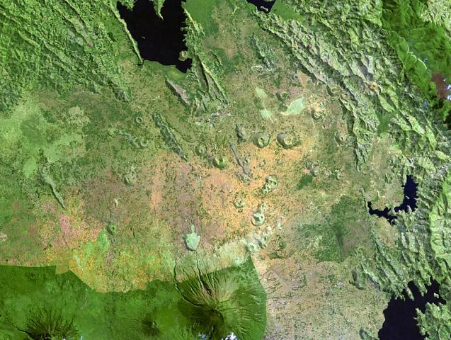
Katunga is a volcanic field rising to 1,707 meters (5,601 feet) in Uganda's Eastern Africa Volcanic Regions. No historical eruptions have been recorded, though the volcano is classified based on geological evidence of past activity.
Geography & Climate
Katunga is located in Uganda, within the Albertine Rift Volcanic Province of the broader Eastern Africa Volcanic Regions. Situated at 0.47° S, 30.19° E in the Southern Hemisphere, the volcano lies within a tropical climate zone. With a summit elevation of 1,707 meters above sea level, Katunga is a moderately sized peak that remains accessible to hikers and researchers for much of the year. The volcanic landform is characterized as a minor, which describes the physical shape and structure of the volcanic edifice as observed from the surface.
GVP Reference Summary
Katunga, an isolated tuff cone with associated lava flows located E of Lake Edward, is the southernmost feature of a N-S-trending chain of high-potassium foditic volcanic fields in the Western Rift Valley of Uganda. It is the type locality of the rock type katungite, an olivine-melilitite. The undissected tuff cone was erupted through metamorphic basement rocks. Its rim and flanks are covered with ejected schists, and it contains a freshwater lake in its summit crater. Two lava flows traveled to the NE from vents on the N and NE flanks. The age of the cone is uncertain, but it is contemporaneous with tuff cones in the Bunyaruguru area to the north.
— Smithsonian Institution, Global Volcanism Program
0 Recorded Eruptions
No eruption records available for Katunga.
Real-Time Data
Frequently Asked Questions About Katunga
Is Katunga an active volcano?+
Katunga is not currently classified as active. Its activity evidence is listed as "unknown." No recorded eruptions have been documented. However, no volcano is ever considered permanently extinct.
How high is Katunga?+
Katunga has a summit elevation of 1,707 meters (5,601 feet) above sea level. At 1,707 meters, it is a moderately sized volcanic peak, roughly comparable to Mount Vesuvius (1,281m).
What type of volcano is Katunga?+
Katunga is classified as a Volcanic field. Volcanic fields consist of clusters of small volcanic vents and cinder cones spread across a region. Rather than a single central vent, eruptions can occur at many points across the field.
Where is Katunga located?+
Katunga is located in Uganda, in the Eastern Africa Volcanic Regions. More specifically, it lies within the Albertine Rift Volcanic Province. Its exact coordinates are -0.471° latitude, 30.191° longitude.
Is it safe to visit Katunga?+
Katunga can generally be visited, but as with any volcano, visitors should check local conditions and any advisory notices before traveling. Uganda may have specific regulations for accessing volcanic areas. Guided tours are often the safest and most informative way to experience a volcano.