About Tajumulco
Tajumulco is a stratovolcano rising to 4,203 meters (13,790 feet) in Guatemala's Middle America-Caribbean Volcanic Regions. No historical eruptions have been recorded, though the volcano is classified based on geological evidence of past activity. The volcano has produced 2 recorded eruptions, with a maximum Volcanic Explosivity Index (VEI) of 2.
Geography & Climate
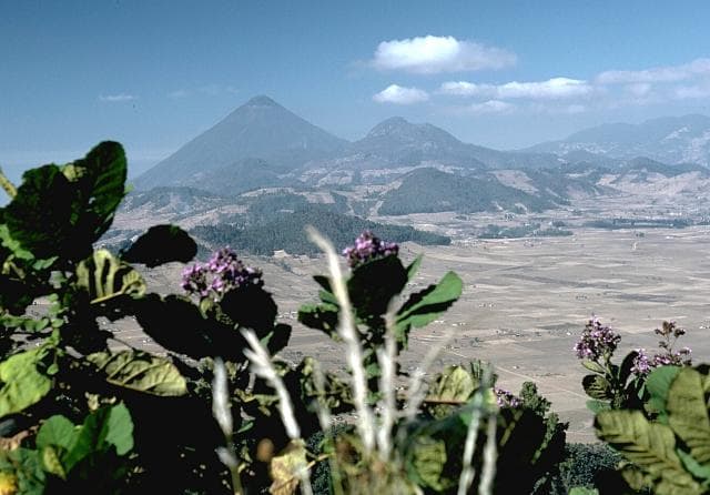
Tajumulco is located in Guatemala, within the Central America Volcanic Arc of the broader Middle America-Caribbean Volcanic Regions. Situated at 15.04° N, 91.90° W in the Northern Hemisphere, the volcano lies within a tropical climate zone. Standing at 4,203 meters above sea level, Tajumulco towers above the alpine zone, where vegetation gives way to bare rock, snow, and ice for much of the year. The high elevation means the upper slopes experience significantly colder temperatures than surrounding lowlands. The volcanic landform is characterized as a composite, which describes the physical shape and structure of the volcanic edifice as observed from the surface.
Geological Context
Tajumulco sits in a subduction zone, where one tectonic plate dives beneath another, creating intense heat and pressure that generates magma. Subduction zones are responsible for many of the world's most explosive volcanoes and deadliest eruptions. For communities in Guatemala near Tajumulco, this tectonic setting means the volcano is capable of producing powerful explosive eruptions, pyroclastic flows, and lahars that can threaten populated areas within tens of kilometers of the summit. The dominant rock type is dacite, an intermediate to silica-rich volcanic rock. This composition typically produces more viscous magma, leading to more explosive eruptions with ash columns and pyroclastic flows. Andesitic and dacitic magmas build pressure before erupting, which is why volcanoes with this rock chemistry are often associated with Plinian-style eruptions that can send ash tens of kilometers into the atmosphere and disrupt aviation across entire regions.
Eruption History Summary
Tajumulco has 2 recorded eruptions in the geological database, spanning from 1821 CE to 1863 CE. The most powerful recorded event was an explosive event producing ash plumes up to several kilometers in 1863 CE, reaching VEI 2 on the Volcanic Explosivity Index. These eruptions span roughly 42 years of volcanic history.
GVP Reference Summary
Tajumulco is Guatemala's highest peak and the highest volcano in Central America. Two summits, one with a 50-70 m wide crater, lie along a NW-SE line. A lava flow from the ~4200-m-high NW summit traveled down a deep valley on the NW flank. The andesitic-dacitic volcano was constructed over the NW end of a large arcuate SW-facing escarpment of uncertain origin. Tajumulco has had several unconfirmed reports of historical eruptions. Sapper (1917) considered it to have erupted during historical time, but without accurate dates. The volcano was reported to eject many rocks, destroying houses on 24 October 1765, but this may have been a rock avalanche. Juarros reported some eruptions before 1808, and there are unlikely reports of eruptions in 1821 (or 1822), 1863, and 1893 (Incer 1988, unpublished manuscript).
— Smithsonian Institution, Global Volcanism Program
2 Recorded Eruptions
| Year | VEI | Type | Area |
|---|---|---|---|
| 1863 | 2 | Uncertain Eruption | — |
| 1821 | 2 | Uncertain Eruption | — |
Real-Time Data
Frequently Asked Questions About Tajumulco
Is Tajumulco an active volcano?+
Tajumulco is classified as active based on credible evidence of past eruptions. Although its last known eruption was in prehistoric times, volcanologists consider it capable of erupting again.
When did Tajumulco last erupt?+
The most recent recorded eruption of Tajumulco occurred in 1863 CE with a Volcanic Explosivity Index (VEI) of 2. The eruption was classified as a "Uncertain Eruption." Tajumulco has 2 recorded eruptions in total.
How high is Tajumulco?+
Tajumulco has a summit elevation of 4,203 meters (13,790 feet) above sea level. At 4,203 meters, it stands taller than Mount Rainier (4,392m) and is among the world's major volcanic peaks.
What type of volcano is Tajumulco?+
Tajumulco is classified as a Stratovolcano. Stratovolcanoes (also called composite volcanoes) are steep, conical volcanoes built up by many layers of hardened lava, tephra, and volcanic ash. They are among the most common and dangerous types, known for explosive eruptions.
Where is Tajumulco located?+
Tajumulco is located in Guatemala, in the Middle America-Caribbean Volcanic Regions. More specifically, it lies within the Central America Volcanic Arc. Its exact coordinates are 15.043° latitude, -91.903° longitude.
Is it safe to visit Tajumulco?+
Tajumulco can generally be visited, but as with any volcano, visitors should check local conditions and any advisory notices before traveling. Guatemala may have specific regulations for accessing volcanic areas. Guided tours are often the safest and most informative way to experience a volcano.