About Tacana
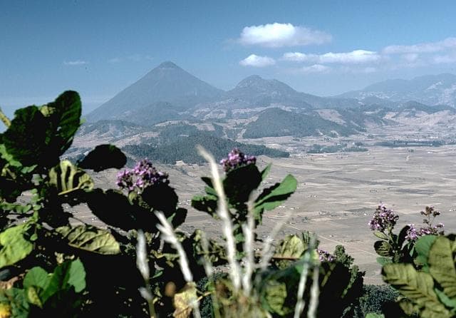
Tacana is a stratovolcano rising to 4,064 meters (13,334 feet) in Mexico-Guatemala's Middle America-Caribbean Volcanic Regions. It last erupted in 1986 CE, and volcanologists consider it an active volcanic system. The volcano has produced 11 recorded eruptions, with a maximum Volcanic Explosivity Index (VEI) of 4.
Geography & Climate
Tacana is located in Mexico-Guatemala, within the Central America Volcanic Arc of the broader Middle America-Caribbean Volcanic Regions. Situated at 15.13° N, 92.11° W in the Northern Hemisphere, the volcano lies within a tropical climate zone. Standing at 4,064 meters above sea level, Tacana towers above the alpine zone, where vegetation gives way to bare rock, snow, and ice for much of the year. The high elevation means the upper slopes experience significantly colder temperatures than surrounding lowlands. The volcanic landform is characterized as a composite, which describes the physical shape and structure of the volcanic edifice as observed from the surface.
Geological Context
Tacana sits in a subduction zone, where one tectonic plate dives beneath another, creating intense heat and pressure that generates magma. Subduction zones are responsible for many of the world's most explosive volcanoes and deadliest eruptions. For communities in Mexico-Guatemala near Tacana, this tectonic setting means the volcano is capable of producing powerful explosive eruptions, pyroclastic flows, and lahars that can threaten populated areas within tens of kilometers of the summit. The dominant rock type is andesite / basaltic andesite, a dark, fine-grained volcanic rock that forms from rapidly cooling, low-viscosity lava. Basaltic eruptions tend to be less explosive and produce fluid lava flows that can travel long distances. While less immediately dangerous than explosive eruptions, basaltic lava flows can destroy structures and infrastructure in their path, and volcanic gases released during these eruptions can affect air quality over a wide area.
Eruption History Summary
Tacana has 11 recorded eruptions in the geological database, spanning from 9450 BCE to 1986 CE. The most powerful recorded event was a cataclysmic eruption with ash columns reaching the stratosphere in 70 CE, reaching VEI 4 on the Volcanic Explosivity Index. This level of eruptive frequency indicates a persistently active volcanic system that warrants ongoing monitoring. The most recent eruption in 1986 CE places this volcano within the modern era of volcanological observation.
Significance
With a maximum recorded VEI of 4, Tacana has demonstrated the capacity for significant explosive eruptions that can impact regional aviation, agriculture, and communities tens of kilometers from the summit. VEI 4 eruptions produce ash columns reaching 15-25 kilometers into the atmosphere. With 11 recorded eruptions, Tacana has a substantial eruptive history that provides valuable data for understanding volcanic behavior and assessing future hazards in the Middle America-Caribbean Volcanic Regions region. Given its recent activity, Tacana is closely monitored by geological survey organizations to provide early warning of future unrest.
GVP Reference Summary
Tacaná is a 4064-m-high composite stratovolcano that straddles the México/Guatemala border at the NW end of the Central American volcanic belt. The volcano rises 1800 m above deeply dissected plutonic and metamorphic terrain. Three large calderas breached to the south, and the elongated summit region is dominated by a series of lava domes intruded along a NE-SW trend. Volcanism has migrated to the SW, and a small adventive lava dome is located in the crater of the youngest volcano, San Antonio, on the upper SW flank. Viscous lava flow complexes are found on the north and south flanks, and lobate lahar deposits fill many valleys. Radial drainages on the Guatemalan side are deflected by surrounding mountains into the Pacific coastal plain on the SW side of the volcano. Historical activity has been restricted to mild phreatic eruptions, but more powerful explosive activity, including the production of pyroclastic flows, has occurred as recently as about 1950 years ago.
— Smithsonian Institution, Global Volcanism Program
11 Recorded Eruptions
| Year | VEI | Type | Area |
|---|---|---|---|
| 1986 | 1 | Confirmed Eruption | NE flank (ca. 3600 m) |
| 1949 | 1 | Confirmed Eruption | SW flank |
| 1878 | 1 | Confirmed Eruption | SW side |
| 1855 | 1 | Uncertain Eruption | SW side |
| 1030 | — | Confirmed Eruption | — |
| 70 | 4 | Confirmed Eruption | San Antonio (upper SW flank) |
| 1080 BCE | — | Confirmed Eruption | — |
| 4740 BCE | — | Confirmed Eruption | — |
| 5720 BCE | — | Confirmed Eruption | — |
| 5940 BCE | — | Confirmed Eruption | — |
| 9450 BCE | — | Confirmed Eruption | — |
Real-Time Data
Frequently Asked Questions About Tacana
Is Tacana an active volcano?+
Yes, Tacana is considered an active volcano. Its most recent eruption was in 1986 CE. The volcano is monitored by geological agencies, and its activity status is based on observed eruptions within recorded history.
When did Tacana last erupt?+
The most recent recorded eruption of Tacana occurred in 1986 CE with a Volcanic Explosivity Index (VEI) of 1. The eruption was classified as a "Confirmed Eruption." Tacana has 11 recorded eruptions in total.
How high is Tacana?+
Tacana has a summit elevation of 4,064 meters (13,334 feet) above sea level. At 4,064 meters, it stands taller than Mount Rainier (4,392m) and is among the world's major volcanic peaks.
What type of volcano is Tacana?+
Tacana is classified as a Stratovolcano. Stratovolcanoes (also called composite volcanoes) are steep, conical volcanoes built up by many layers of hardened lava, tephra, and volcanic ash. They are among the most common and dangerous types, known for explosive eruptions.
Where is Tacana located?+
Tacana is located in Mexico-Guatemala, in the Middle America-Caribbean Volcanic Regions. More specifically, it lies within the Central America Volcanic Arc. Its exact coordinates are 15.132° latitude, -92.109° longitude.
Is it safe to visit Tacana?+
Visiting Tacana requires checking current volcanic activity and alert levels. As an active volcano with eruptions as recent as 1986 CE, conditions can change rapidly. Always consult local geological authorities and follow official warnings before visiting. Many active volcanoes have designated safe viewing areas and guided tour options.