About Santa Maria
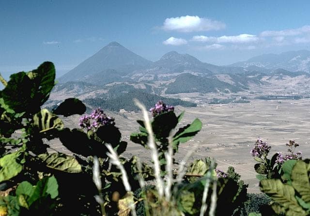
Santa Maria is a stratovolcano rising to 3,745 meters (12,287 feet) in Guatemala's Middle America-Caribbean Volcanic Regions. The volcano is currently active, with its most recent eruption in 2025 CE. The volcano has produced 3 recorded eruptions, with a maximum Volcanic Explosivity Index (VEI) of 6.
Geography & Climate
Santa Maria is located in Guatemala, within the Central America Volcanic Arc of the broader Middle America-Caribbean Volcanic Regions. Situated at 14.76° N, 91.55° W in the Northern Hemisphere, the volcano lies within a tropical climate zone. Standing at 3,745 meters above sea level, Santa Maria towers above the alpine zone, where vegetation gives way to bare rock, snow, and ice for much of the year. The high elevation means the upper slopes experience significantly colder temperatures than surrounding lowlands. The volcanic landform is characterized as a composite, which describes the physical shape and structure of the volcanic edifice as observed from the surface.
Geological Context
Santa Maria sits in a subduction zone, where one tectonic plate dives beneath another, creating intense heat and pressure that generates magma. Subduction zones are responsible for many of the world's most explosive volcanoes and deadliest eruptions. For communities in Guatemala near Santa Maria, this tectonic setting means the volcano is capable of producing powerful explosive eruptions, pyroclastic flows, and lahars that can threaten populated areas within tens of kilometers of the summit. The dominant rock type is dacite, an intermediate to silica-rich volcanic rock. This composition typically produces more viscous magma, leading to more explosive eruptions with ash columns and pyroclastic flows. Andesitic and dacitic magmas build pressure before erupting, which is why volcanoes with this rock chemistry are often associated with Plinian-style eruptions that can send ash tens of kilometers into the atmosphere and disrupt aviation across entire regions.
Eruption History Summary
Santa Maria has 3 recorded eruptions in the geological database, spanning from 1902 CE to 1922 CE. The most powerful recorded event was a colossal eruption capable of affecting global climate for years in 1902 CE, reaching VEI 6 on the Volcanic Explosivity Index. Notable eruptions include 1922 CE (VEI 3), 1902 CE (VEI 6). These eruptions span roughly 20 years of volcanic history. The most recent eruption in 1922 CE places this volcano within the modern era of volcanological observation.
Significance
Santa Maria has produced at least one eruption of VEI 6 or higher, placing it among the most powerful volcanic systems on Earth. Eruptions of this magnitude inject massive quantities of sulfur dioxide into the stratosphere, affecting global climate by lowering average temperatures for one to three years after the event.
GVP Reference Summary
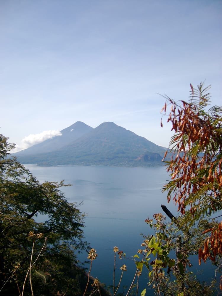
Symmetrical, forest-covered Santa María volcano is part of a chain of large stratovolcanoes that rise above the Pacific coastal plain of Guatemala. The sharp-topped, conical profile is cut on the SW flank by a 1.5-km-wide crater. The oval-shaped crater extends from just below the summit to the lower flank, and was formed during a catastrophic eruption in 1902. The renowned Plinian eruption of 1902 that devastated much of SW Guatemala followed a long repose period after construction of the large basaltic andesite stratovolcano. The massive dacitic Santiaguito lava-dome complex has been growing at the base of the 1902 crater since 1922. Compound dome growth at Santiaguito has occurred episodically from four vents, with activity progressing E towards the most recent, Caliente. Dome growth has been accompanied by almost continuous minor explosions, with periodic lava extrusion, larger explosions, pyroclastic flows, and lahars.
— Smithsonian Institution, Global Volcanism Program
3 Recorded Eruptions
| Year | VEI | Type | Area |
|---|---|---|---|
| 1922 | 3 | Confirmed Eruption | SW flank (Santiaguito) |
| 1903 | 2 | Confirmed Eruption | SW flank (east end of 1902 crater) |
| 1902 | 6 | Confirmed Eruption | SW flank |
Real-Time Data
Frequently Asked Questions About Santa Maria
Is Santa Maria an active volcano?+
Yes, Santa Maria is considered an active volcano. Its most recent eruption was in 2025 CE. The volcano is monitored by geological agencies, and its activity status is based on observed eruptions within recorded history.
When did Santa Maria last erupt?+
The most recent recorded eruption of Santa Maria occurred in 1922 CE with a Volcanic Explosivity Index (VEI) of 3. The eruption was classified as a "Confirmed Eruption." Santa Maria has 3 recorded eruptions in total.
How high is Santa Maria?+
Santa Maria has a summit elevation of 3,745 meters (12,287 feet) above sea level. At 3,745 meters, it is comparable in height to many significant mountain peaks and stands well above the tree line.
What type of volcano is Santa Maria?+
Santa Maria is classified as a Stratovolcano. Stratovolcanoes (also called composite volcanoes) are steep, conical volcanoes built up by many layers of hardened lava, tephra, and volcanic ash. They are among the most common and dangerous types, known for explosive eruptions.
Where is Santa Maria located?+
Santa Maria is located in Guatemala, in the Middle America-Caribbean Volcanic Regions. More specifically, it lies within the Central America Volcanic Arc. Its exact coordinates are 14.757° latitude, -91.552° longitude.
Is it safe to visit Santa Maria?+
Visiting Santa Maria requires checking current volcanic activity and alert levels. As an active volcano with eruptions as recent as 2025 CE, conditions can change rapidly. Always consult local geological authorities and follow official warnings before visiting. Many active volcanoes have designated safe viewing areas and guided tour options.