About Atlixcos, Los
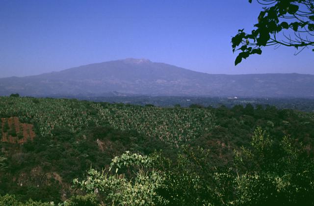
Atlixcos, Los is a shield rising to 775 meters (2,543 feet) in Mexico's Middle America-Caribbean Volcanic Regions. No historical eruptions have been recorded, though the volcano is classified based on geological evidence of past activity.
Geography & Climate
Atlixcos, Los is located in Mexico, within the Trans-Mexican Volcanic Arc of the broader Middle America-Caribbean Volcanic Regions. Situated at 19.81° N, 96.53° W in the Northern Hemisphere, the volcano lies within a tropical climate zone. With a summit elevation of 775 meters above sea level, Atlixcos, Los is a moderately sized peak that remains accessible to hikers and researchers for much of the year. The volcanic landform is characterized as a shield, which describes the physical shape and structure of the volcanic edifice as observed from the surface.
Geological Context
Atlixcos, Los sits in a subduction zone, where one tectonic plate dives beneath another, creating intense heat and pressure that generates magma. Subduction zones are responsible for many of the world's most explosive volcanoes and deadliest eruptions. For communities in Mexico near Atlixcos, Los, this tectonic setting means the volcano is capable of producing powerful explosive eruptions, pyroclastic flows, and lahars that can threaten populated areas within tens of kilometers of the summit. The dominant rock type is basalt / picro-basalt, a dark, fine-grained volcanic rock that forms from rapidly cooling, low-viscosity lava. Basaltic eruptions tend to be less explosive and produce fluid lava flows that can travel long distances. While less immediately dangerous than explosive eruptions, basaltic lava flows can destroy structures and infrastructure in their path, and volcanic gases released during these eruptions can affect air quality over a wide area.
GVP Reference Summary
Los Atlixcos, also known as Cerro el Abra, consists of a broad area of lava flows topped by two large cones at the eastern end of the Mexican Volcanic Belt along the Gulf of Mexico about 80 km NW of the city of Veracruz. The two cones, together known as Cerro los Atlixcos, lie 2 km apart with the larger one to the W. A broad area of basaltic lava flows extends primarily to the E and NE, reaching the coast about 9 km from the western cone. The boundaries of the lava shield are defined by the Río Santa Ana on the NE and the Río El Tecuán on the S. Negendank et al. (1985) considered them to be of Holocene age based on morphology. Other Quaternary cones are located to the NW, and a group of cones and silicic lava domes of Tertiary-to-Quaternary age were constructed along the coast to the SE.
— Smithsonian Institution, Global Volcanism Program
0 Recorded Eruptions
No eruption records available for Atlixcos, Los.
Real-Time Data
Frequently Asked Questions About Atlixcos, Los
Is Atlixcos, Los an active volcano?+
Atlixcos, Los is classified as active based on credible evidence of past eruptions. Although its last known eruption was in prehistoric times, volcanologists consider it capable of erupting again.
How high is Atlixcos, Los?+
Atlixcos, Los has a summit elevation of 775 meters (2,543 feet) above sea level. At 775 meters, it is a relatively low-elevation volcano.
What type of volcano is Atlixcos, Los?+
Atlixcos, Los is classified as a Shield. Shield volcanoes have distinct geological characteristics that set them apart from other volcanic types.
Where is Atlixcos, Los located?+
Atlixcos, Los is located in Mexico, in the Middle America-Caribbean Volcanic Regions. More specifically, it lies within the Trans-Mexican Volcanic Arc. Its exact coordinates are 19.810° latitude, -96.527° longitude.
Is it safe to visit Atlixcos, Los?+
Atlixcos, Los can generally be visited, but as with any volcano, visitors should check local conditions and any advisory notices before traveling. Mexico may have specific regulations for accessing volcanic areas. Guided tours are often the safest and most informative way to experience a volcano.