About Kilauea
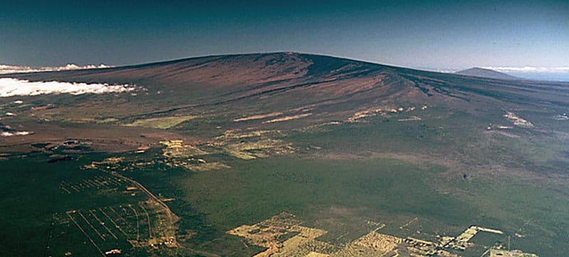
Kilauea is a shield rising to 1,222 meters (4,009 feet) in United States's Eastern Pacific Volcanic Regions. The volcano is currently active, with its most recent eruption in 2025 CE. The volcano has produced 20 recorded eruptions, with a maximum Volcanic Explosivity Index (VEI) of 3.
Geography & Climate
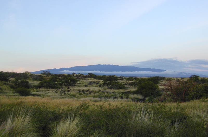
Kilauea is located in United States, within the Hawaiian-Emperor Hotspot Volcano Group of the broader Eastern Pacific Volcanic Regions. Situated at 19.42° N, 155.29° W in the Northern Hemisphere, the volcano lies within a tropical climate zone. With a summit elevation of 1,222 meters above sea level, Kilauea is a moderately sized peak that remains accessible to hikers and researchers for much of the year. The volcanic landform is characterized as a shield, which describes the physical shape and structure of the volcanic edifice as observed from the surface.
Geological Context
Kilauea is an intraplate volcano, meaning it formed away from any plate boundary. These volcanoes are often powered by hotspots — plumes of abnormally hot mantle material rising from deep within the Earth. Hotspot volcanoes like Kilauea tend to produce effusive eruptions with lava flows that can be relatively predictable, giving nearby communities in United States more time to prepare. However, they can also produce explosive phases, particularly when magma interacts with groundwater. The dominant rock type is basalt / picro-basalt, a dark, fine-grained volcanic rock that forms from rapidly cooling, low-viscosity lava. Basaltic eruptions tend to be less explosive and produce fluid lava flows that can travel long distances. While less immediately dangerous than explosive eruptions, basaltic lava flows can destroy structures and infrastructure in their path, and volcanic gases released during these eruptions can affect air quality over a wide area.
Eruption History Summary
Kilauea has 20 recorded eruptions in the geological database, spanning from 1961 CE to 2024 CE. The most powerful recorded event was a severe eruption capable of regional ash fall and pyroclastic flows in 1983 CE, reaching VEI 3 on the Volcanic Explosivity Index. With an average interval of roughly 3 years between eruptions over a span of 63 years, this is one of the more frequently active volcanoes in the database. This persistent activity suggests a robust and well-supplied magma system beneath the volcano. With eruptive activity as recently as 2024 CE, Kilauea remains an actively monitored volcano.
Significance
With a maximum recorded VEI of 3, Kilauea has produced eruptions capable of generating pyroclastic flows and significant ash fall in the surrounding area. While not among the largest eruptions globally, VEI 3 events pose serious hazards to local populations and can disrupt regional air travel. Its 20 recorded eruptions make it one of the most prolific volcanoes in our database, reflecting a persistent and well-documented eruptive history that has provided volcanologists with extensive data for understanding eruption patterns and forecasting future activity. Given its recent activity, Kilauea is closely monitored by geological survey organizations to provide early warning of future unrest.
GVP Reference Summary
Kilauea overlaps the E flank of the massive Mauna Loa shield volcano in the island of Hawaii. Eruptions are prominent in Polynesian legends; written documentation since 1820 records frequent summit and flank lava flow eruptions interspersed with periods of long-term lava lake activity at Halemaumau crater in the summit caldera until 1924. The 3 x 5 km caldera was formed in several stages about 1,500 years ago and during the 18th century; eruptions have also originated from the lengthy East and Southwest rift zones, which extend to the ocean in both directions. About 90% of the surface of the basaltic shield volcano is formed of lava flows less than about 1,100 years old; 70% of the surface is younger than 600 years. The long-term eruption from the East rift zone between 1983 and 2018 produced lava flows covering more than 100 km2, destroyed hundreds of houses, and added new coastline.
— Smithsonian Institution, Global Volcanism Program
20 Recorded Eruptions
| Year | VEI | Type | Area |
|---|---|---|---|
| 2024 | 0 | Confirmed Eruption | Southwest Rift Zone |
| 2024 | 0 | Confirmed Eruption | Napau Crater |
| 2024 | 0 | Confirmed Eruption | Halema'uma'u Crater |
| 2021 | 0 | Confirmed Eruption | Halema`uma`u Crater. |
| 2020 | 0 | Confirmed Eruption | — |
| 1983 | 3 | Confirmed Eruption | East rift zone (Puu O'o), Halemaumau |
| 1982 | 0 | Confirmed Eruption | Kilauea Caldera (NE of Halemaumau) |
| 1982 | 0 | Confirmed Eruption | Kilauea Caldera (SSE of Halemaumau) |
| 1980 | 0 | Confirmed Eruption | East rift zone (near Mauna Ulu) |
| 1979 | 0 | Confirmed Eruption | East rift zone (Pauahi Crater) |
| 1977 | 0 | Confirmed Eruption | East rift zone (near Kalalua Crater) |
| 1975 | 0 | Confirmed Eruption | Kilauea Caldera, Halemaumau |
| 1974 | 0 | Confirmed Eruption | Southwest Rift Zone (1,095 m) |
| 1969 | 0 | Confirmed Eruption | East rift zone (885-945 m), Alae Crater |
| 1967 | 0 | Confirmed Eruption | Halemaumau |
| 1965 | 0 | Confirmed Eruption | East rift zone (700-915 m) |
| 1965 | 0 | Confirmed Eruption | East rift zone (915-960 m) |
| 1963 | 0 | Confirmed Eruption | East rift zone (825-960 m) |
| 1962 | 0 | Confirmed Eruption | East rift zone (945-990 m) |
| 1961 | 1 | Confirmed Eruption | Halemaumau |
Real-Time Data
Frequently Asked Questions About Kilauea
Is Kilauea an active volcano?+
Yes, Kilauea is considered an active volcano. Its most recent eruption was in 2025 CE. The volcano is monitored by geological agencies, and its activity status is based on observed eruptions within recorded history.
When did Kilauea last erupt?+
The most recent recorded eruption of Kilauea occurred in 2024 CE with a Volcanic Explosivity Index (VEI) of 0. The eruption was classified as a "Confirmed Eruption." Kilauea has 20 recorded eruptions in total.
How high is Kilauea?+
Kilauea has a summit elevation of 1,222 meters (4,009 feet) above sea level. At 1,222 meters, it is a moderately sized volcanic peak, roughly comparable to Mount Vesuvius (1,281m).
What type of volcano is Kilauea?+
Kilauea is classified as a Shield. Shield volcanoes have distinct geological characteristics that set them apart from other volcanic types.
Where is Kilauea located?+
Kilauea is located in United States, in the Eastern Pacific Volcanic Regions. More specifically, it lies within the Hawaiian-Emperor Hotspot Volcano Group. Its exact coordinates are 19.421° latitude, -155.287° longitude.
Is it safe to visit Kilauea?+
Visiting Kilauea requires checking current volcanic activity and alert levels. As an active volcano with eruptions as recent as 2025 CE, conditions can change rapidly. Always consult local geological authorities and follow official warnings before visiting. Many active volcanoes have designated safe viewing areas and guided tour options.