About Banda Api
Banda Api is a caldera rising to 596 meters (1,955 feet) in Indonesia's Sunda-Banda Volcanic Regions. It last erupted in 1988 CE, and volcanologists consider it an active volcanic system. The volcano has produced 20 recorded eruptions, with a maximum Volcanic Explosivity Index (VEI) of 3.
Geography & Climate
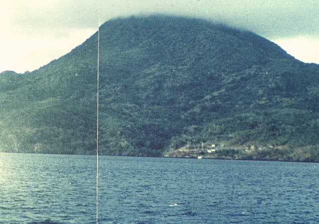
Banda Api is located in Indonesia, within the Inner Banda Volcanic Arc of the broader Sunda-Banda Volcanic Regions. Situated at 4.52° S, 129.88° E in the Southern Hemisphere, the volcano lies within a tropical climate zone. With a summit elevation of 596 meters above sea level, Banda Api is a moderately sized peak that remains accessible to hikers and researchers for much of the year. The volcanic landform is characterized as a composite, which describes the physical shape and structure of the volcanic edifice as observed from the surface.
Geological Context
Banda Api sits in a subduction zone, where one tectonic plate dives beneath another, creating intense heat and pressure that generates magma. Subduction zones are responsible for many of the world's most explosive volcanoes and deadliest eruptions. For communities in Indonesia near Banda Api, this tectonic setting means the volcano is capable of producing powerful explosive eruptions, pyroclastic flows, and lahars that can threaten populated areas within tens of kilometers of the summit. The dominant rock type is dacite, an intermediate to silica-rich volcanic rock. This composition typically produces more viscous magma, leading to more explosive eruptions with ash columns and pyroclastic flows. Andesitic and dacitic magmas build pressure before erupting, which is why volcanoes with this rock chemistry are often associated with Plinian-style eruptions that can send ash tens of kilometers into the atmosphere and disrupt aviation across entire regions.
Eruption History Summary
Banda Api has 20 recorded eruptions in the geological database, spanning from 1683 CE to 1988 CE. The most powerful recorded event was a severe eruption capable of regional ash fall and pyroclastic flows in 1988 CE, reaching VEI 3 on the Volcanic Explosivity Index. Notable eruptions include 1988 CE (VEI 3), 1690 CE (VEI 3), 1683 CE (VEI 3). With an average interval of roughly 15 years between eruptions over a span of 305 years, this is one of the more frequently active volcanoes in the database. This persistent activity suggests a robust and well-supplied magma system beneath the volcano. The most recent eruption in 1988 CE places this volcano within the modern era of volcanological observation.
Significance
With a maximum recorded VEI of 3, Banda Api has produced eruptions capable of generating pyroclastic flows and significant ash fall in the surrounding area. While not among the largest eruptions globally, VEI 3 events pose serious hazards to local populations and can disrupt regional air travel. Its 20 recorded eruptions make it one of the most prolific volcanoes in our database, reflecting a persistent and well-documented eruptive history that has provided volcanologists with extensive data for understanding eruption patterns and forecasting future activity. Given its recent activity, Banda Api is closely monitored by geological survey organizations to provide early warning of future unrest.
GVP Reference Summary
The 3-km-wide island of Banda Api is the northern-most volcano in the Banda arc and has a long period of recorded observation because of its key location in the Portuguese and Dutch spice trade. The basaltic-to-rhyodacitic volcano is located in the SW corner of a mostly submerged 7 km caldera. At least two episodes of caldera formation are thought to have occurred, with the arcuate islands of Lonthor and Neira considered to be pre-caldera remnants. A conical peak rises to about 600 m at the center of the island. Eruptions have been recorded since 1586 CE, mostly consisting of Strombolian eruptions from the summit crater, but larger explosive eruptions have occurred and occasional lava flows have reached the coast.
— Smithsonian Institution, Global Volcanism Program
20 Recorded Eruptions
| Year | VEI | Type | Area |
|---|---|---|---|
| 1988 | 3 | Confirmed Eruption | Summit, north and south flanks |
| 1902 | — | Uncertain Eruption | — |
| 1901 | 2 | Confirmed Eruption | Summit and north flank |
| 1890 | 2 | Confirmed Eruption | — |
| 1855 | — | Uncertain Eruption | — |
| 1835 | — | Uncertain Eruption | — |
| 1825 | 1 | Confirmed Eruption | — |
| 1824 | 2 | Confirmed Eruption | North side |
| 1820 | 2 | Confirmed Eruption | Summit, south and NNW flanks |
| 1816 | 2 | Confirmed Eruption | — |
| 1778 | 2 | Confirmed Eruption | — |
| 1775 | 2 | Confirmed Eruption | — |
| 1773 | 2 | Confirmed Eruption | — |
| 1765 | 2 | Confirmed Eruption | — |
| 1762 | 2 | Confirmed Eruption | — |
| 1749 | 2 | Confirmed Eruption | — |
| 1722 | 2 | Confirmed Eruption | — |
| 1712 | 2 | Confirmed Eruption | — |
| 1690 | 3 | Confirmed Eruption | — |
| 1683 | 3 | Confirmed Eruption | — |
Real-Time Data
Frequently Asked Questions About Banda Api
Is Banda Api an active volcano?+
Yes, Banda Api is considered an active volcano. Its most recent eruption was in 1988 CE. The volcano is monitored by geological agencies, and its activity status is based on observed eruptions within recorded history.
When did Banda Api last erupt?+
The most recent recorded eruption of Banda Api occurred in 1988 CE with a Volcanic Explosivity Index (VEI) of 3. The eruption was classified as a "Confirmed Eruption." Banda Api has 20 recorded eruptions in total.
How high is Banda Api?+
Banda Api has a summit elevation of 596 meters (1,955 feet) above sea level. At 596 meters, it is a relatively low-elevation volcano.
What type of volcano is Banda Api?+
Banda Api is classified as a Caldera. Calderas are large volcanic depressions formed when a volcano erupts so powerfully that its magma chamber collapses, creating a basin that can be kilometers wide. They are often sites of some of Earth's largest eruptions.
Where is Banda Api located?+
Banda Api is located in Indonesia, in the Sunda-Banda Volcanic Regions. More specifically, it lies within the Inner Banda Volcanic Arc. Its exact coordinates are -4.523° latitude, 129.881° longitude.
Is it safe to visit Banda Api?+
Visiting Banda Api requires checking current volcanic activity and alert levels. As an active volcano with eruptions as recent as 1988 CE, conditions can change rapidly. Always consult local geological authorities and follow official warnings before visiting. Many active volcanoes have designated safe viewing areas and guided tour options.