About Lihir
Lihir is a compound rising to 700 meters (2,297 feet) in Papua New Guinea's Southwestern Pacific Volcanic Regions. No historical eruptions have been recorded, though the volcano is classified based on geological evidence of past activity.
Geography & Climate
Lihir is located in Papua New Guinea, within the New Ireland Volcanic Province of the broader Southwestern Pacific Volcanic Regions. Situated at 3.12° S, 152.60° E in the Southern Hemisphere, the volcano lies within a tropical climate zone. With a summit elevation of 700 meters above sea level, Lihir is a moderately sized peak that remains accessible to hikers and researchers for much of the year. The volcanic landform is characterized as a composite, which describes the physical shape and structure of the volcanic edifice as observed from the surface.
GVP Reference Summary
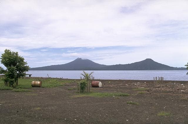
The Lihir Group of islands N of New Ireland is a Pliocene-to-Pleistocene volcanic complex that is the exposed part of a submarine edifice ~12 km in diameter. Five stratovolcanoes form the large island of Aniolam (or Lihir): Huniho (NW), Wurtol (S central), Luise (E central), Londolovit (N), and Kinami (SE). Luise consists of an elliptical 5.5-km-wide edifice collapse scarp breached by the sea on the NE side that formed about 400,000 years ago. The flanks are only moderately dissected, and the steep scarp wall rises to 700 m above sea level. A central lava plug is strongly hydrothermally altered and displays extensive thermal activity along its margins. Thermal activity includes boiling hot springs, mud pools, and sulfur-encrusted low-temperature fumaroles. Open pit mining of the Ladolam hydrothermal deposit, hosted in the collapse scarp adjacent to the harbor, began in 1997. The Kinami volcano, which is also now a collapse feature, is thought to be the youngest on the island, but no eruption dates are known.
— Smithsonian Institution, Global Volcanism Program
0 Recorded Eruptions
No eruption records available for Lihir.
Real-Time Data
Frequently Asked Questions About Lihir
Is Lihir an active volcano?+
Lihir is not currently classified as active. Its activity evidence is listed as "unknown." No recorded eruptions have been documented. However, no volcano is ever considered permanently extinct.
How high is Lihir?+
Lihir has a summit elevation of 700 meters (2,297 feet) above sea level. At 700 meters, it is a relatively low-elevation volcano.
What type of volcano is Lihir?+
Lihir is classified as a Compound. Compound volcanoes have distinct geological characteristics that set them apart from other volcanic types.
Where is Lihir located?+
Lihir is located in Papua New Guinea, in the Southwestern Pacific Volcanic Regions. More specifically, it lies within the New Ireland Volcanic Province. Its exact coordinates are -3.122° latitude, 152.600° longitude.
Is it safe to visit Lihir?+
Lihir can generally be visited, but as with any volcano, visitors should check local conditions and any advisory notices before traveling. Papua New Guinea may have specific regulations for accessing volcanic areas. Guided tours are often the safest and most informative way to experience a volcano.