About Rabaul
Rabaul is a caldera rising to 688 meters (2,257 feet) in Papua New Guinea's Southwestern Pacific Volcanic Regions. It has been active in recent decades, with its last eruption in 2014 CE. The volcano has produced 19 recorded eruptions, with a maximum Volcanic Explosivity Index (VEI) of 6.
Geography & Climate
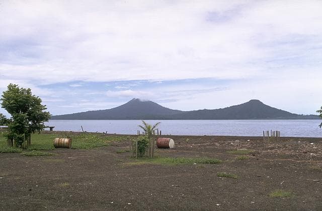
Rabaul is located in Papua New Guinea, within the Bismarck Volcanic Arc of the broader Southwestern Pacific Volcanic Regions. Situated at 4.25° S, 152.19° E in the Southern Hemisphere, the volcano lies within a tropical climate zone. With a summit elevation of 688 meters above sea level, Rabaul is a moderately sized peak that remains accessible to hikers and researchers for much of the year. The volcanic landform is characterized as a caldera, which describes the physical shape and structure of the volcanic edifice as observed from the surface.
Geological Context
Rabaul sits in a subduction zone, where one tectonic plate dives beneath another, creating intense heat and pressure that generates magma. Subduction zones are responsible for many of the world's most explosive volcanoes and deadliest eruptions. For communities in Papua New Guinea near Rabaul, this tectonic setting means the volcano is capable of producing powerful explosive eruptions, pyroclastic flows, and lahars that can threaten populated areas within tens of kilometers of the summit. The dominant rock type is dacite, an intermediate to silica-rich volcanic rock. This composition typically produces more viscous magma, leading to more explosive eruptions with ash columns and pyroclastic flows. Andesitic and dacitic magmas build pressure before erupting, which is why volcanoes with this rock chemistry are often associated with Plinian-style eruptions that can send ash tens of kilometers into the atmosphere and disrupt aviation across entire regions.
Eruption History Summary
Rabaul has 19 recorded eruptions in the geological database, spanning from 683 CE to 2014 CE. The most powerful recorded event was a colossal eruption capable of affecting global climate for years in 683 CE, reaching VEI 6 on the Volcanic Explosivity Index. Notable eruptions include 2014 CE (VEI 3), 2006 CE (VEI 4), 1994 CE (VEI 4). This level of eruptive frequency indicates a persistently active volcanic system that warrants ongoing monitoring. With eruptive activity as recently as 2014 CE, Rabaul remains an actively monitored volcano.
Significance
Rabaul has produced at least one eruption of VEI 6 or higher, placing it among the most powerful volcanic systems on Earth. Eruptions of this magnitude inject massive quantities of sulfur dioxide into the stratosphere, affecting global climate by lowering average temperatures for one to three years after the event. With 19 recorded eruptions, Rabaul has a substantial eruptive history that provides valuable data for understanding volcanic behavior and assessing future hazards in the Southwestern Pacific Volcanic Regions region. Given its recent activity, Rabaul is closely monitored by geological survey organizations to provide early warning of future unrest.
GVP Reference Summary
The low-lying Rabaul caldera on the tip of the Gazelle Peninsula at the NE end of New Britain forms a broad sheltered harbor utilized by what was the island's largest city prior to a major eruption in 1994. The outer flanks of the asymmetrical shield volcano are formed by thick pyroclastic-flow deposits. The 8 x 14 km caldera is widely breached on the east, where its floor is flooded by Blanche Bay and was formed about 1,400 years ago. An earlier caldera-forming eruption about 7,100 years ago is thought to have originated from Tavui caldera, offshore to the north. Three small stratovolcanoes lie outside the N and NE caldera rims. Post-caldera eruptions built basaltic-to-dacitic pyroclastic cones on the caldera floor near the NE and W caldera walls. Several of these, including Vulcan cone, which was formed during a large eruption in 1878, have produced major explosive activity during historical time. A powerful explosive eruption in 1994 occurred simultaneously from Vulcan and Tavurvur volcanoes and forced the temporary abandonment of Rabaul city.
— Smithsonian Institution, Global Volcanism Program
19 Recorded Eruptions
| Year | VEI | Type | Area |
|---|---|---|---|
| 2014 | 3 | Confirmed Eruption | Tavurvur |
| 2013 | 2 | Confirmed Eruption | Tavurvur |
| 2011 | 2 | Confirmed Eruption | Tavurvur |
| 2010 | 1 | Confirmed Eruption | Tavurvur |
| 2006 | 4 | Confirmed Eruption | Tavurvur |
| 2005 | 2 | Confirmed Eruption | Tavurvur |
| 2002 | 2 | Confirmed Eruption | Tavurvur |
| 1995 | 2 | Confirmed Eruption | Tavurvur |
| 1994 | 4 | Confirmed Eruption | Tavurvur and Vulcan |
| 1943 | 2 | Confirmed Eruption | Tavurvur |
| 1941 | 2 | Confirmed Eruption | Tavurvur |
| 1940 | 1 | Confirmed Eruption | Tavurvur |
| 1937 | 4 | Confirmed Eruption | Vulcan and Tavurvur |
| 1878 | 3 | Confirmed Eruption | Vulcan Island and Tavurvur |
| 1850 | 2 | Confirmed Eruption | Sulfur Creek |
| 1791 | 2 | Confirmed Eruption | Tavurvur |
| 1767 | 2 | Confirmed Eruption | Tavurvur ? |
| 1450 | — | Confirmed Eruption | NE caldera rim (Rabalanakia) |
| 683 | 6 | Confirmed Eruption | — |
Real-Time Data
Frequently Asked Questions About Rabaul
Is Rabaul an active volcano?+
Yes, Rabaul is considered an active volcano. Its most recent eruption was in 2014 CE. The volcano is monitored by geological agencies, and its activity status is based on observed eruptions within recorded history.
When did Rabaul last erupt?+
The most recent recorded eruption of Rabaul occurred in 2014 CE with a Volcanic Explosivity Index (VEI) of 3. The eruption was classified as a "Confirmed Eruption." Rabaul has 19 recorded eruptions in total.
How high is Rabaul?+
Rabaul has a summit elevation of 688 meters (2,257 feet) above sea level. At 688 meters, it is a relatively low-elevation volcano.
What type of volcano is Rabaul?+
Rabaul is classified as a Caldera. Calderas are large volcanic depressions formed when a volcano erupts so powerfully that its magma chamber collapses, creating a basin that can be kilometers wide. They are often sites of some of Earth's largest eruptions.
Where is Rabaul located?+
Rabaul is located in Papua New Guinea, in the Southwestern Pacific Volcanic Regions. More specifically, it lies within the Bismarck Volcanic Arc. Its exact coordinates are -4.246° latitude, 152.194° longitude.
Is it safe to visit Rabaul?+
Visiting Rabaul requires checking current volcanic activity and alert levels. As an active volcano with eruptions as recent as 2014 CE, conditions can change rapidly. Always consult local geological authorities and follow official warnings before visiting. Many active volcanoes have designated safe viewing areas and guided tour options.