About Lolobau
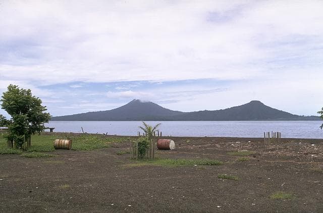
Lolobau is a caldera rising to 878 meters (2,881 feet) in Papua New Guinea's Southwestern Pacific Volcanic Regions. It last erupted in 1912 CE, and volcanologists consider it an active volcanic system. The volcano has produced 4 recorded eruptions, with a maximum Volcanic Explosivity Index (VEI) of 4.
Geography & Climate
Lolobau is located in Papua New Guinea, within the Bismarck Volcanic Arc of the broader Southwestern Pacific Volcanic Regions. Situated at 4.92° S, 151.16° E in the Southern Hemisphere, the volcano lies within a tropical climate zone. With a summit elevation of 878 meters above sea level, Lolobau is a moderately sized peak that remains accessible to hikers and researchers for much of the year. The volcanic landform is characterized as a caldera, which describes the physical shape and structure of the volcanic edifice as observed from the surface.
Geological Context
Lolobau sits in a subduction zone, where one tectonic plate dives beneath another, creating intense heat and pressure that generates magma. Subduction zones are responsible for many of the world's most explosive volcanoes and deadliest eruptions. For communities in Papua New Guinea near Lolobau, this tectonic setting means the volcano is capable of producing powerful explosive eruptions, pyroclastic flows, and lahars that can threaten populated areas within tens of kilometers of the summit. The dominant rock type is basalt / picro-basalt, a dark, fine-grained volcanic rock that forms from rapidly cooling, low-viscosity lava. Basaltic eruptions tend to be less explosive and produce fluid lava flows that can travel long distances. While less immediately dangerous than explosive eruptions, basaltic lava flows can destroy structures and infrastructure in their path, and volcanic gases released during these eruptions can affect air quality over a wide area.
Eruption History Summary
Lolobau has 4 recorded eruptions in the geological database, spanning from 1100 CE to 1911 CE. The most powerful recorded event was a cataclysmic eruption with ash columns reaching the stratosphere in 1911 CE, reaching VEI 4 on the Volcanic Explosivity Index. Notable eruptions include 1911 CE (VEI 4), 1904 CE (VEI 4), 1100 CE (VEI 4). These eruptions span roughly 811 years of volcanic history. The most recent eruption in 1911 CE places this volcano within the modern era of volcanological observation.
Significance
With a maximum recorded VEI of 4, Lolobau has demonstrated the capacity for significant explosive eruptions that can impact regional aviation, agriculture, and communities tens of kilometers from the summit. VEI 4 eruptions produce ash columns reaching 15-25 kilometers into the atmosphere.
GVP Reference Summary
Lolobau volcano has grown over the W rim of a 6-km-wide caldera which formed about 12,000 years ago. The 8 x 13 km island is located just off the coast of eastern New Britain. A small lake occupies the SW part of the caldera. A small lava dome (Hulu) caps Mount Lolobau, which has a 0.8 x 1.1 km summit crater breached to the NE. Flank cones are found along the coast of the largely submerged volcano. Several vents within the caldera, on the E flank of the main edifice, have been active during historical time. The latest eruptions took place during the early 20th century.
— Smithsonian Institution, Global Volcanism Program
4 Recorded Eruptions
| Year | VEI | Type | Area |
|---|---|---|---|
| 1911 | 4 | Confirmed Eruption | East flank (Sili) |
| 1908 | — | Uncertain Eruption | — |
| 1904 | 4 | Confirmed Eruption | East flank (Sili, Malo), Hulu ? |
| 1100 | 4 | Confirmed Eruption | Hulu |
Real-Time Data
Frequently Asked Questions About Lolobau
Is Lolobau an active volcano?+
Yes, Lolobau is considered an active volcano. Its most recent eruption was in 1912 CE. The volcano is monitored by geological agencies, and its activity status is based on observed eruptions within recorded history.
When did Lolobau last erupt?+
The most recent recorded eruption of Lolobau occurred in 1911 CE with a Volcanic Explosivity Index (VEI) of 4. The eruption was classified as a "Confirmed Eruption." Lolobau has 4 recorded eruptions in total.
How high is Lolobau?+
Lolobau has a summit elevation of 878 meters (2,881 feet) above sea level. At 878 meters, it is a relatively low-elevation volcano.
What type of volcano is Lolobau?+
Lolobau is classified as a Caldera. Calderas are large volcanic depressions formed when a volcano erupts so powerfully that its magma chamber collapses, creating a basin that can be kilometers wide. They are often sites of some of Earth's largest eruptions.
Where is Lolobau located?+
Lolobau is located in Papua New Guinea, in the Southwestern Pacific Volcanic Regions. More specifically, it lies within the Bismarck Volcanic Arc. Its exact coordinates are -4.916° latitude, 151.162° longitude.
Is it safe to visit Lolobau?+
Visiting Lolobau requires checking current volcanic activity and alert levels. As an active volcano with eruptions as recent as 1912 CE, conditions can change rapidly. Always consult local geological authorities and follow official warnings before visiting. Many active volcanoes have designated safe viewing areas and guided tour options.


