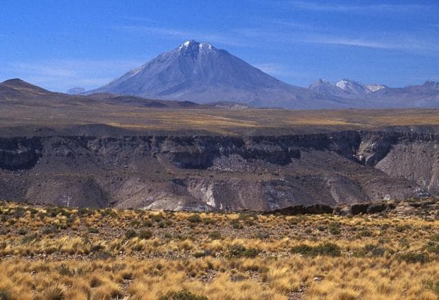
About Taapaca
Taapaca is a complex rising to 5,860 meters (19,227 feet) in Chile's South America Volcanic Regions. Its last known eruption dates to 320 BCE, in prehistoric times. The volcano has produced 8 recorded eruptions.
Geography & Climate
Taapaca is located in Chile, within the Central Andean Volcanic Arc of the broader South America Volcanic Regions. Situated at 18.10° S, 69.50° W in the Southern Hemisphere, the volcano lies within a tropical climate zone. At 5,860 meters above sea level, Taapaca reaches well into the permanent snow and ice zone. Glaciers and snowpack on the upper slopes create the potential for lahars — destructive volcanic mudflows — during eruptions, as heat rapidly melts ice and snow. The volcanic landform is characterized as a composite, which describes the physical shape and structure of the volcanic edifice as observed from the surface.
Geological Context
Taapaca sits in a subduction zone, where one tectonic plate dives beneath another, creating intense heat and pressure that generates magma. Subduction zones are responsible for many of the world's most explosive volcanoes and deadliest eruptions. For communities in Chile near Taapaca, this tectonic setting means the volcano is capable of producing powerful explosive eruptions, pyroclastic flows, and lahars that can threaten populated areas within tens of kilometers of the summit. The dominant rock type is dacite, an intermediate to silica-rich volcanic rock. This composition typically produces more viscous magma, leading to more explosive eruptions with ash columns and pyroclastic flows. Andesitic and dacitic magmas build pressure before erupting, which is why volcanoes with this rock chemistry are often associated with Plinian-style eruptions that can send ash tens of kilometers into the atmosphere and disrupt aviation across entire regions.
Eruption History Summary
Taapaca has 8 recorded eruptions in the geological database, spanning from 7900 BCE to 320 BCE. This eruption frequency indicates a moderately active volcanic system with periodic reawakenings.
Significance
With 8 recorded eruptions on file, Taapaca has enough documented activity to help scientists identify patterns in its eruptive behavior.
GVP Reference Summary
The Taapaca volcanic complex, lying W of the main Andean chain, rises NE of the small town of Putre, the principal settlement of the northern Chilean Altiplano. The elongated volcanic massif, known locally as Nevados de Putre, consists of an andesitic stratovolcano and a dacitic lava-dome complex. It overlies Pleistocene ignimbrite deposits and trends roughly E-W, with activity migrating generally to the SW during four principal periods of activity dating back at least 1.5 million years. At least three major edifice collapse events have produced debris-avalanche deposits, the youngest of which underlies Putre. Studies have shown that explosive activity with dome growth and associated block-and-ash flows and lahars continued into the late Holocene. The youngest volcanic stage, beginning about 9000 years ago, produced the summit lava dome of the Putre Unit at the E and S ends of the complex. The latest documented activity produced an ash layer dated ~2000 years ago.
— Smithsonian Institution, Global Volcanism Program
8 Recorded Eruptions
| Year | VEI | Type | Area |
|---|---|---|---|
| 320 BCE | — | Confirmed Eruption | — |
| 1580 BCE | — | Confirmed Eruption | — |
| 1860 BCE | — | Confirmed Eruption | — |
| 2400 BCE | — | Confirmed Eruption | — |
| 2950 BCE | — | Confirmed Eruption | — |
| 4620 BCE | — | Confirmed Eruption | — |
| 5490 BCE | — | Confirmed Eruption | — |
| 7900 BCE | — | Confirmed Eruption | — |
Real-Time Data
Frequently Asked Questions About Taapaca
Is Taapaca an active volcano?+
Taapaca is not currently classified as active. Its activity evidence is listed as "Eruption Dated." The last known eruption was in 320 BCE. However, no volcano is ever considered permanently extinct.
When did Taapaca last erupt?+
The most recent recorded eruption of Taapaca occurred in 320 BCE. The eruption was classified as a "Confirmed Eruption." Taapaca has 8 recorded eruptions in total.
How high is Taapaca?+
Taapaca has a summit elevation of 5,860 meters (19,227 feet) above sea level. At 5,860 meters, it stands taller than Mount Rainier (4,392m) and is among the world's major volcanic peaks.
What type of volcano is Taapaca?+
Taapaca is classified as a Complex. Complex volcanoes have distinct geological characteristics that set them apart from other volcanic types.
Where is Taapaca located?+
Taapaca is located in Chile, in the South America Volcanic Regions. More specifically, it lies within the Central Andean Volcanic Arc. Its exact coordinates are -18.100° latitude, -69.500° longitude.
Is it safe to visit Taapaca?+
Taapaca can generally be visited, but as with any volcano, visitors should check local conditions and any advisory notices before traveling. Chile may have specific regulations for accessing volcanic areas. Guided tours are often the safest and most informative way to experience a volcano.