About Parinacota
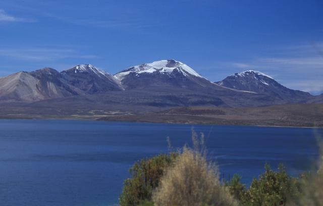
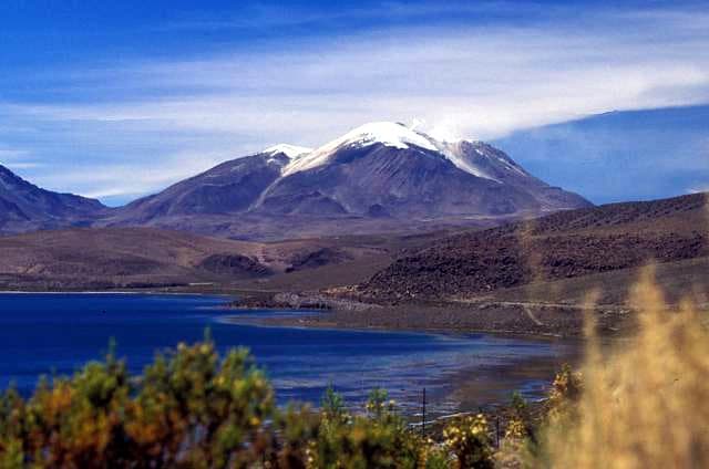
Parinacota is a stratovolcano rising to 6,336 meters (20,788 feet) in Chile-Bolivia's South America Volcanic Regions. Its last known eruption was in 290 CE. The volcano has produced 6 recorded eruptions, with a maximum Volcanic Explosivity Index (VEI) of 4.
Geography & Climate
Parinacota is located in Chile-Bolivia, within the Central Andean Volcanic Arc of the broader South America Volcanic Regions. Situated at 18.17° S, 69.14° W in the Southern Hemisphere, the volcano lies within a tropical climate zone. At 6,336 meters above sea level, Parinacota reaches well into the permanent snow and ice zone. Glaciers and snowpack on the upper slopes create the potential for lahars — destructive volcanic mudflows — during eruptions, as heat rapidly melts ice and snow. The volcanic landform is characterized as a composite, which describes the physical shape and structure of the volcanic edifice as observed from the surface.
Geological Context
Parinacota sits in a subduction zone, where one tectonic plate dives beneath another, creating intense heat and pressure that generates magma. Subduction zones are responsible for many of the world's most explosive volcanoes and deadliest eruptions. For communities in Chile-Bolivia near Parinacota, this tectonic setting means the volcano is capable of producing powerful explosive eruptions, pyroclastic flows, and lahars that can threaten populated areas within tens of kilometers of the summit. The dominant rock type is andesite / basaltic andesite, a dark, fine-grained volcanic rock that forms from rapidly cooling, low-viscosity lava. Basaltic eruptions tend to be less explosive and produce fluid lava flows that can travel long distances. While less immediately dangerous than explosive eruptions, basaltic lava flows can destroy structures and infrastructure in their path, and volcanic gases released during these eruptions can affect air quality over a wide area.
Eruption History Summary
Parinacota has 6 recorded eruptions in the geological database, spanning from 7950 BCE to 290 CE. The most powerful recorded event was a cataclysmic eruption with ash columns reaching the stratosphere in 290 CE, reaching VEI 4 on the Volcanic Explosivity Index. This eruption frequency indicates a moderately active volcanic system with periodic reawakenings.
Significance
With a maximum recorded VEI of 4, Parinacota has demonstrated the capacity for significant explosive eruptions that can impact regional aviation, agriculture, and communities tens of kilometers from the summit. VEI 4 eruptions produce ash columns reaching 15-25 kilometers into the atmosphere. With 6 recorded eruptions on file, Parinacota has enough documented activity to help scientists identify patterns in its eruptive behavior.
GVP Reference Summary
The symmetrical Volcán Parinacota is the southernmost and youngest of a pair of volcanoes forming the Nevados de Payachata group along the Chile-Bolivia border. The dominantly Pleistocene Pomerape volcano towers above a low saddle to the NE. Collapse of Parinacota about 8,000 years ago produced a 6 km3 debris avalanche that traveled 22 km W and blocked drainages, forming Lake Chungará. Holocene eruptive activity has subsequently reconstructed the stratovolcano, which contains a pristine, 300-m-wide summit crater and youthful lava flows on the W flanks. Although no historical eruptions are known, Helium surface-exposure dates have been obtained for eruptions during the past two thousand years both from the main cone and the Ajata group of satellite cones and lava flows on the S and SW flanks.
— Smithsonian Institution, Global Volcanism Program
6 Recorded Eruptions
| Year | VEI | Type | Area |
|---|---|---|---|
| 290 | 4 | Confirmed Eruption | Parinacota 3 edifice |
| 90 | — | Confirmed Eruption | South flank (upper Volcanes de Ajata) |
| 1100 BCE | — | Confirmed Eruption | South flank (lower Volcanes de Ajata) |
| 4320 BCE | — | Confirmed Eruption | South flank (lower Volcanes de Ajata) |
| 5840 BCE | — | Confirmed Eruption | — |
| 7950 BCE | — | Confirmed Eruption | Ajata |
Real-Time Data
Frequently Asked Questions About Parinacota
Is Parinacota an active volcano?+
Parinacota is not currently classified as active. Its activity evidence is listed as "Eruption Dated." The last known eruption was in 290 CE. However, no volcano is ever considered permanently extinct.
When did Parinacota last erupt?+
The most recent recorded eruption of Parinacota occurred in 290 CE with a Volcanic Explosivity Index (VEI) of 4. The eruption was classified as a "Confirmed Eruption." Parinacota has 6 recorded eruptions in total.
How high is Parinacota?+
Parinacota has a summit elevation of 6,336 meters (20,788 feet) above sea level. This makes it one of the tallest volcanoes in the world, comparable in height to some of the highest peaks in the Andes.
What type of volcano is Parinacota?+
Parinacota is classified as a Stratovolcano. Stratovolcanoes (also called composite volcanoes) are steep, conical volcanoes built up by many layers of hardened lava, tephra, and volcanic ash. They are among the most common and dangerous types, known for explosive eruptions.
Where is Parinacota located?+
Parinacota is located in Chile-Bolivia, in the South America Volcanic Regions. More specifically, it lies within the Central Andean Volcanic Arc. Its exact coordinates are -18.166° latitude, -69.142° longitude.
Is it safe to visit Parinacota?+
Parinacota can generally be visited, but as with any volcano, visitors should check local conditions and any advisory notices before traveling. Chile-Bolivia may have specific regulations for accessing volcanic areas. Guided tours are often the safest and most informative way to experience a volcano.