About Guallatiri
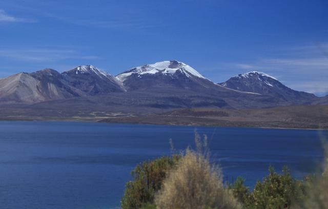
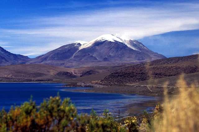
Guallatiri is a stratovolcano rising to 6,071 meters (19,919 feet) in Chile's South America Volcanic Regions. It last erupted in 1960 CE, and volcanologists consider it an active volcanic system. The volcano has produced 6 recorded eruptions, with a maximum Volcanic Explosivity Index (VEI) of 2.
Geography & Climate
Guallatiri is located in Chile, within the Central Andean Volcanic Arc of the broader South America Volcanic Regions. Situated at 18.42° S, 69.09° W in the Southern Hemisphere, the volcano lies within a tropical climate zone. At 6,071 meters above sea level, Guallatiri reaches well into the permanent snow and ice zone. Glaciers and snowpack on the upper slopes create the potential for lahars — destructive volcanic mudflows — during eruptions, as heat rapidly melts ice and snow. The volcanic landform is characterized as a composite, which describes the physical shape and structure of the volcanic edifice as observed from the surface.
Geological Context
Guallatiri sits in a subduction zone, where one tectonic plate dives beneath another, creating intense heat and pressure that generates magma. Subduction zones are responsible for many of the world's most explosive volcanoes and deadliest eruptions. For communities in Chile near Guallatiri, this tectonic setting means the volcano is capable of producing powerful explosive eruptions, pyroclastic flows, and lahars that can threaten populated areas within tens of kilometers of the summit. The dominant rock type is andesite / basaltic andesite, a dark, fine-grained volcanic rock that forms from rapidly cooling, low-viscosity lava. Basaltic eruptions tend to be less explosive and produce fluid lava flows that can travel long distances. While less immediately dangerous than explosive eruptions, basaltic lava flows can destroy structures and infrastructure in their path, and volcanic gases released during these eruptions can affect air quality over a wide area.
Eruption History Summary
Guallatiri has 6 recorded eruptions in the geological database, spanning from 1825 CE to 1985 CE. The most powerful recorded event was an explosive event producing ash plumes up to several kilometers in 1960 CE, reaching VEI 2 on the Volcanic Explosivity Index. This eruption frequency indicates a moderately active volcanic system with periodic reawakenings. The most recent eruption in 1985 CE places this volcano within the modern era of volcanological observation.
Significance
With 6 recorded eruptions on file, Guallatiri has enough documented activity to help scientists identify patterns in its eruptive behavior. Given its recent activity, Guallatiri is closely monitored by geological survey organizations to provide early warning of future unrest.
GVP Reference Summary
One of northern Chile's most active volcanoes, Volcán Guallatiri is a symmetrical ice-clad stratovolcano at the SW end of the Nevados de Quimsachata volcano group. It lies just W of the border with Bolivia and is capped by a central dacitic dome or lava complex, with the active vent situated on its S side. Thick lava flows are prominent on the lower N and W flanks of the andesitic-to-rhyolitic volcano. Minor explosive eruptions have been reported since the beginning of the 19th century. Intense fumarolic activity with "jet-like" noises continues, and numerous solfataras extend more than 300 m down the W flank.
— Smithsonian Institution, Global Volcanism Program
6 Recorded Eruptions
| Year | VEI | Type | Area |
|---|---|---|---|
| 1985 | — | Uncertain Eruption | — |
| 1960 | 2 | Confirmed Eruption | — |
| 1959 | 2 | Confirmed Eruption | — |
| 1913 | 2 | Confirmed Eruption | — |
| 1908 | — | Uncertain Eruption | — |
| 1825 | 2 | Confirmed Eruption | — |
Real-Time Data
Frequently Asked Questions About Guallatiri
Is Guallatiri an active volcano?+
Yes, Guallatiri is considered an active volcano. Its most recent eruption was in 1960 CE. The volcano is monitored by geological agencies, and its activity status is based on observed eruptions within recorded history.
When did Guallatiri last erupt?+
The most recent recorded eruption of Guallatiri occurred in 1985 CE. The eruption was classified as a "Uncertain Eruption." Guallatiri has 6 recorded eruptions in total.
How high is Guallatiri?+
Guallatiri has a summit elevation of 6,071 meters (19,919 feet) above sea level. This makes it one of the tallest volcanoes in the world, comparable in height to some of the highest peaks in the Andes.
What type of volcano is Guallatiri?+
Guallatiri is classified as a Stratovolcano. Stratovolcanoes (also called composite volcanoes) are steep, conical volcanoes built up by many layers of hardened lava, tephra, and volcanic ash. They are among the most common and dangerous types, known for explosive eruptions.
Where is Guallatiri located?+
Guallatiri is located in Chile, in the South America Volcanic Regions. More specifically, it lies within the Central Andean Volcanic Arc. Its exact coordinates are -18.420° latitude, -69.092° longitude.
Is it safe to visit Guallatiri?+
Visiting Guallatiri requires checking current volcanic activity and alert levels. As an active volcano with eruptions as recent as 1960 CE, conditions can change rapidly. Always consult local geological authorities and follow official warnings before visiting. Many active volcanoes have designated safe viewing areas and guided tour options.