About Nyiragongo
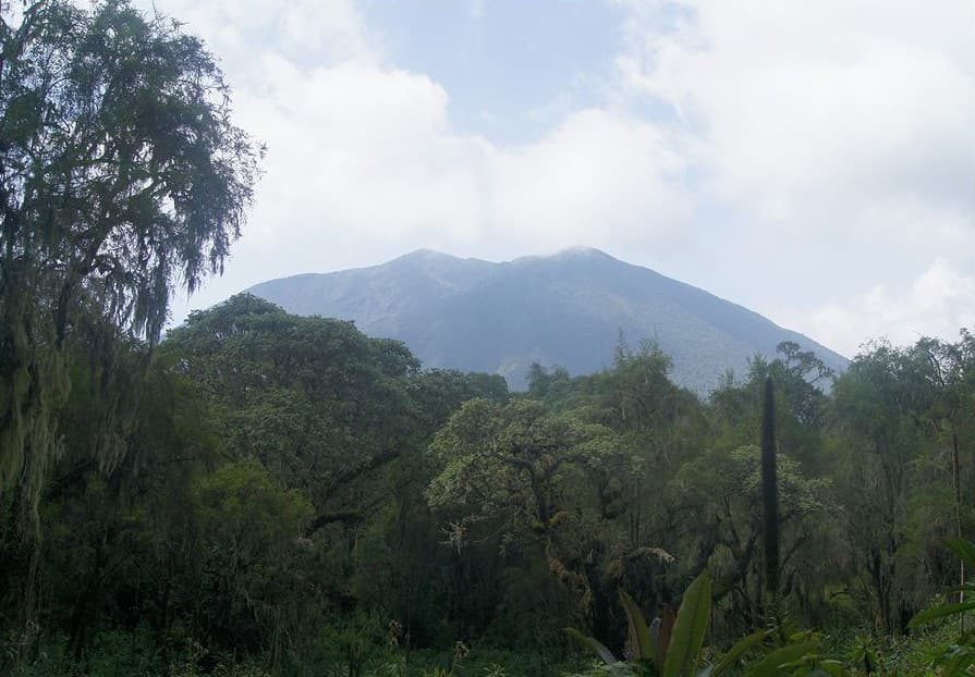
Nyiragongo is a stratovolcano rising to 3,470 meters (11,385 feet) in DR Congo's Eastern Africa Volcanic Regions. The volcano is currently active, with its most recent eruption in 2025 CE. The volcano has produced 20 recorded eruptions, with a maximum Volcanic Explosivity Index (VEI) of 2.
Geography & Climate
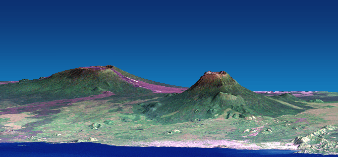
Nyiragongo is located in DR Congo, within the Albertine Rift Volcanic Province of the broader Eastern Africa Volcanic Regions. Situated at 1.52° S, 29.25° E in the Southern Hemisphere, the volcano lies within a tropical climate zone. At 3,470 meters above sea level, Nyiragongo rises above the surrounding terrain into montane or subalpine conditions. The elevation creates distinct ecological zones along its flanks, from forested lower slopes to exposed rocky terrain near the summit. The volcanic landform is characterized as a composite, which describes the physical shape and structure of the volcanic edifice as observed from the surface.
Geological Context
Nyiragongo is situated along a rift zone, where tectonic plates are pulling apart. As the crust thins and fractures, magma rises to fill the gap, creating volcanic activity. Rift volcanism typically produces more fluid lava flows rather than explosive blasts, which means communities near Nyiragongo in DR Congo generally face slower-moving hazards like lava flows and ground fissures rather than sudden pyroclastic events. However, rift volcanoes can still generate significant ash emissions and gas releases that affect local air quality. The dominant rock type is foidite, which influences the viscosity of the magma and, consequently, the style of eruptions this volcano produces. Rock chemistry is one of the most important factors in determining whether a volcano erupts explosively or effusively.
Eruption History Summary
Nyiragongo has 20 recorded eruptions in the geological database, spanning from 1884 CE to 2002 CE. The most powerful recorded event was an explosive event producing ash plumes up to several kilometers in 2002 CE, reaching VEI 2 on the Volcanic Explosivity Index. With an average interval of roughly 6 years between eruptions over a span of 118 years, this is one of the more frequently active volcanoes in the database. This persistent activity suggests a robust and well-supplied magma system beneath the volcano. With eruptive activity as recently as 2002 CE, Nyiragongo remains an actively monitored volcano.
Significance
Its 20 recorded eruptions make it one of the most prolific volcanoes in our database, reflecting a persistent and well-documented eruptive history that has provided volcanologists with extensive data for understanding eruption patterns and forecasting future activity. Given its recent activity, Nyiragongo is closely monitored by geological survey organizations to provide early warning of future unrest.
GVP Reference Summary
The Nyiragongo stratovolcano contained a lava lake in its deep summit crater that was active for half a century before draining catastrophically through its outer flanks in 1977. The steep slopes contrast to the low profile of its neighboring shield volcano, Nyamuragira. Benches in the steep-walled, 1.2-km-wide summit crater mark levels of former lava lakes, which have been observed since the late-19th century. Two older stratovolcanoes, Baruta and Shaheru, are partially overlapped by Nyiragongo on the north and south. About 100 cones are located primarily along radial fissures south of Shaheru, east of the summit, and along a NE-SW zone extending as far as Lake Kivu. Many cones are buried by voluminous lava flows that extend long distances down the flanks, which is characterized by the eruption of foiditic rocks. The extremely fluid 1977 lava flows caused many fatalities, as did lava flows that inundated portions of the major city of Goma in January 2002.
— Smithsonian Institution, Global Volcanism Program
20 Recorded Eruptions
| Year | VEI | Type | Area |
|---|---|---|---|
| 2002 | 1 | Confirmed Eruption | South flank (2800-1570 m), summit crater |
| 2002 | 2 | Confirmed Eruption | — |
| 1994 | 1 | Confirmed Eruption | — |
| 1982 | 1 | Confirmed Eruption | — |
| 1977 | 1 | Confirmed Eruption | North, south, and west flanks |
| 1927 | 1 | Confirmed Eruption | — |
| 1920 | 1 | Confirmed Eruption | — |
| 1918 | 1 | Confirmed Eruption | — |
| 1911 | 1 | Confirmed Eruption | Southern pit |
| 1908 | — | Uncertain Eruption | Southern craters |
| 1906 | 1 | Confirmed Eruption | — |
| 1905 | 1 | Confirmed Eruption | — |
| 1902 | 1 | Confirmed Eruption | — |
| 1901 | 1 | Confirmed Eruption | — |
| 1900 | 1 | Confirmed Eruption | — |
| 1899 | 1 | Confirmed Eruption | — |
| 1898 | 1 | Confirmed Eruption | — |
| 1894 | 1 | Confirmed Eruption | — |
| 1891 | — | Confirmed Eruption | Volcano Uncertain: probably Nyiragongo |
| 1884 | 1 | Confirmed Eruption | Southern pit |
Real-Time Data
Frequently Asked Questions About Nyiragongo
Is Nyiragongo an active volcano?+
Yes, Nyiragongo is considered an active volcano. Its most recent eruption was in 2025 CE. The volcano is monitored by geological agencies, and its activity status is based on observed eruptions within recorded history.
When did Nyiragongo last erupt?+
The most recent recorded eruption of Nyiragongo occurred in 2002 CE with a Volcanic Explosivity Index (VEI) of 1. The eruption was classified as a "Confirmed Eruption." Nyiragongo has 20 recorded eruptions in total.
How high is Nyiragongo?+
Nyiragongo has a summit elevation of 3,470 meters (11,385 feet) above sea level. At 3,470 meters, it is comparable in height to many significant mountain peaks and stands well above the tree line.
What type of volcano is Nyiragongo?+
Nyiragongo is classified as a Stratovolcano. Stratovolcanoes (also called composite volcanoes) are steep, conical volcanoes built up by many layers of hardened lava, tephra, and volcanic ash. They are among the most common and dangerous types, known for explosive eruptions.
Where is Nyiragongo located?+
Nyiragongo is located in DR Congo, in the Eastern Africa Volcanic Regions. More specifically, it lies within the Albertine Rift Volcanic Province. Its exact coordinates are -1.520° latitude, 29.250° longitude.
Is it safe to visit Nyiragongo?+
Visiting Nyiragongo requires checking current volcanic activity and alert levels. As an active volcano with eruptions as recent as 2025 CE, conditions can change rapidly. Always consult local geological authorities and follow official warnings before visiting. Many active volcanoes have designated safe viewing areas and guided tour options.