About Meru
Meru is a stratovolcano rising to 4,550 meters (14,929 feet) in Tanzania's Eastern Africa Volcanic Regions. It last erupted in 1910 CE, and volcanologists consider it an active volcanic system. The volcano has produced 4 recorded eruptions, with a maximum Volcanic Explosivity Index (VEI) of 4.
Geography & Climate
Meru is located in Tanzania, within the Kenyan Rift Volcanic Province of the broader Eastern Africa Volcanic Regions. Situated at 3.24° S, 36.75° E in the Southern Hemisphere, the volcano lies within a tropical climate zone. Standing at 4,550 meters above sea level, Meru towers above the alpine zone, where vegetation gives way to bare rock, snow, and ice for much of the year. The high elevation means the upper slopes experience significantly colder temperatures than surrounding lowlands. The volcanic landform is characterized as a composite, which describes the physical shape and structure of the volcanic edifice as observed from the surface.
Geological Context
Meru is situated along a rift zone, where tectonic plates are pulling apart. As the crust thins and fractures, magma rises to fill the gap, creating volcanic activity. Rift volcanism typically produces more fluid lava flows rather than explosive blasts, which means communities near Meru in Tanzania generally face slower-moving hazards like lava flows and ground fissures rather than sudden pyroclastic events. However, rift volcanoes can still generate significant ash emissions and gas releases that affect local air quality. The dominant rock type is phonolite, an alkaline volcanic rock that indicates a distinct magma chemistry linked to unique tectonic conditions. This composition can produce both effusive and explosive eruptions, with magma viscosity depending on specific mineral content and gas concentrations at the time of eruption.
Eruption History Summary
Meru has 4 recorded eruptions in the geological database, spanning from 5850 BCE to 1910 CE. The most powerful recorded event was a cataclysmic eruption with ash columns reaching the stratosphere in 5850 BCE, reaching VEI 4 on the Volcanic Explosivity Index. These eruptions span roughly 7,760 years of volcanic history. The most recent eruption in 1910 CE places this volcano within the modern era of volcanological observation.
Significance
With a maximum recorded VEI of 4, Meru has demonstrated the capacity for significant explosive eruptions that can impact regional aviation, agriculture, and communities tens of kilometers from the summit. VEI 4 eruptions produce ash columns reaching 15-25 kilometers into the atmosphere.
GVP Reference Summary
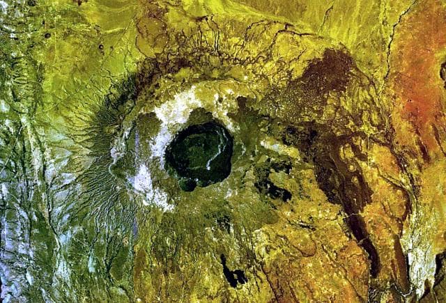
Meru has a conical profile when viewed from the west, but there is a 4-km-wide collapse crater to the E. The summit collapse is associated with the early Holocene Momella event that resulted in debris avalanche and lahar deposits as far as the W flank of Kilimanjaro. Cones and lava domes are located on all sides; a maar field is present on the lower N flank. Activty from the Ash Cone, inside the open crater, was reported around 1878 and in 1910 CE. A second vent between it and the headwall produced lava flows that cover much of the caldera floor. Kisaka et al. (2021) identified three late Pleistocene explosive eruptions during 31-38 ka BP (cal 14C).
— Smithsonian Institution, Global Volcanism Program
4 Recorded Eruptions
| Year | VEI | Type | Area |
|---|---|---|---|
| 1910 | 2 | Confirmed Eruption | Ash Cone |
| 1886 | 0 | Confirmed Eruption | Dome NW of Ash Cone |
| 1878 | 2 | Confirmed Eruption | Dome NW of Ash Cone |
| 5850 BCE | 4 | Confirmed Eruption | — |
Real-Time Data
Frequently Asked Questions About Meru
Is Meru an active volcano?+
Yes, Meru is considered an active volcano. Its most recent eruption was in 1910 CE. The volcano is monitored by geological agencies, and its activity status is based on observed eruptions within recorded history.
When did Meru last erupt?+
The most recent recorded eruption of Meru occurred in 1910 CE with a Volcanic Explosivity Index (VEI) of 2. The eruption was classified as a "Confirmed Eruption." Meru has 4 recorded eruptions in total.
How high is Meru?+
Meru has a summit elevation of 4,550 meters (14,929 feet) above sea level. At 4,550 meters, it stands taller than Mount Rainier (4,392m) and is among the world's major volcanic peaks.
What type of volcano is Meru?+
Meru is classified as a Stratovolcano. Stratovolcanoes (also called composite volcanoes) are steep, conical volcanoes built up by many layers of hardened lava, tephra, and volcanic ash. They are among the most common and dangerous types, known for explosive eruptions.
Where is Meru located?+
Meru is located in Tanzania, in the Eastern Africa Volcanic Regions. More specifically, it lies within the Kenyan Rift Volcanic Province. Its exact coordinates are -3.244° latitude, 36.750° longitude.
Is it safe to visit Meru?+
Visiting Meru requires checking current volcanic activity and alert levels. As an active volcano with eruptions as recent as 1910 CE, conditions can change rapidly. Always consult local geological authorities and follow official warnings before visiting. Many active volcanoes have designated safe viewing areas and guided tour options.