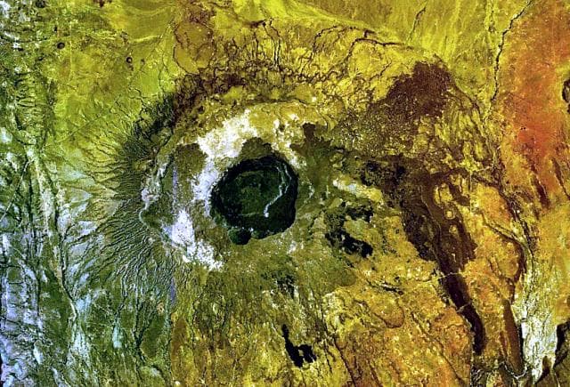
About Chyulu Hills
Chyulu Hills is a volcanic field rising to 2,188 meters (7,179 feet) in Kenya's Eastern Africa Volcanic Regions. Its last known eruption was in 1855 CE. The volcano has produced 3 recorded eruptions, with a maximum Volcanic Explosivity Index (VEI) of 2.
Geography & Climate
Chyulu Hills is located in Kenya, within the Kenyan Rift Volcanic Province of the broader Eastern Africa Volcanic Regions. Situated at 2.68° S, 37.88° E in the Southern Hemisphere, the volcano lies within a tropical climate zone. At 2,188 meters above sea level, Chyulu Hills rises above the surrounding terrain into montane or subalpine conditions. The elevation creates distinct ecological zones along its flanks, from forested lower slopes to exposed rocky terrain near the summit. The volcanic landform is characterized as a cluster, which describes the physical shape and structure of the volcanic edifice as observed from the surface.
Geological Context
Chyulu Hills is situated along a rift zone, where tectonic plates are pulling apart. As the crust thins and fractures, magma rises to fill the gap, creating volcanic activity. Rift volcanism typically produces more fluid lava flows rather than explosive blasts, which means communities near Chyulu Hills in Kenya generally face slower-moving hazards like lava flows and ground fissures rather than sudden pyroclastic events. However, rift volcanoes can still generate significant ash emissions and gas releases that affect local air quality. The dominant rock type is trachybasalt / tephrite basanite, a dark, fine-grained volcanic rock that forms from rapidly cooling, low-viscosity lava. Basaltic eruptions tend to be less explosive and produce fluid lava flows that can travel long distances. While less immediately dangerous than explosive eruptions, basaltic lava flows can destroy structures and infrastructure in their path, and volcanic gases released during these eruptions can affect air quality over a wide area.
Eruption History Summary
Chyulu Hills has 3 recorded eruptions in the geological database, spanning from 2250 BCE to 1855 CE. The most powerful recorded event was an explosive event producing ash plumes up to several kilometers in 1855 CE, reaching VEI 2 on the Volcanic Explosivity Index. These eruptions span roughly 4,105 years of volcanic history.
GVP Reference Summary
The 100-km-long NW-SE-trending Chyulu Hills volcanic field is located 150 km E of the Kenya Rift. It contains several hundred small cones and flows, including numerous recent cinder cones. Two of these, Shaitani and Chainu, erupted during the mid-19th century. Volcanic activity began about 1.4 million years ago with eruptions in the northern Chyulu Hills and migrated to the SE, where a large number of Holocene cones are found. Many of the cinder cones are aligned along dominantly NW-trending older faults and younger NNE-trending fissures. The silica contents of the lava flows increased with time. Early flows consisted of foidites; later Holocene lava flows are basanites and alkali basalts. Six tephra deposits from Lake Chala were attibuted by Martin-Jones et al. (2020) to Pleistocene eruptions in the Chyulu Hills (~87-16.8 ka), along with one Holocene mafic cryptotephra 14C dated at about 4.2 ka.
— Smithsonian Institution, Global Volcanism Program
3 Recorded Eruptions
| Year | VEI | Type | Area |
|---|---|---|---|
| 1855 | 2 | Confirmed Eruption | Shaitani and Chaimu |
| 1470 | — | Confirmed Eruption | Umani |
| 2250 BCE | — | Confirmed Eruption | — |
Real-Time Data
Frequently Asked Questions About Chyulu Hills
Is Chyulu Hills an active volcano?+
Chyulu Hills is not currently classified as active. Its activity evidence is listed as "Eruption Dated." The last known eruption was in 1855 CE. However, no volcano is ever considered permanently extinct.
When did Chyulu Hills last erupt?+
The most recent recorded eruption of Chyulu Hills occurred in 1855 CE with a Volcanic Explosivity Index (VEI) of 2. The eruption was classified as a "Confirmed Eruption." Chyulu Hills has 3 recorded eruptions in total.
How high is Chyulu Hills?+
Chyulu Hills has a summit elevation of 2,188 meters (7,179 feet) above sea level. At 2,188 meters, it is comparable in height to many significant mountain peaks and stands well above the tree line.
What type of volcano is Chyulu Hills?+
Chyulu Hills is classified as a Volcanic field. Volcanic fields consist of clusters of small volcanic vents and cinder cones spread across a region. Rather than a single central vent, eruptions can occur at many points across the field.
Where is Chyulu Hills located?+
Chyulu Hills is located in Kenya, in the Eastern Africa Volcanic Regions. More specifically, it lies within the Kenyan Rift Volcanic Province. Its exact coordinates are -2.680° latitude, 37.880° longitude.
Is it safe to visit Chyulu Hills?+
Chyulu Hills can generally be visited, but as with any volcano, visitors should check local conditions and any advisory notices before traveling. Kenya may have specific regulations for accessing volcanic areas. Guided tours are often the safest and most informative way to experience a volcano.