About Lengai, Ol Doinyo
Lengai, Ol Doinyo is a stratovolcano rising to 2,962 meters (9,718 feet) in Tanzania's Eastern Africa Volcanic Regions. The volcano is currently active, with its most recent eruption in 2025 CE. The volcano has produced 20 recorded eruptions, with a maximum Volcanic Explosivity Index (VEI) of 3.
Geography & Climate
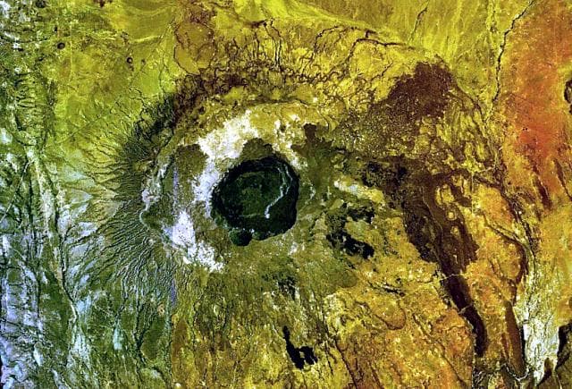
Lengai, Ol Doinyo is located in Tanzania, within the Kenyan Rift Volcanic Province of the broader Eastern Africa Volcanic Regions. Situated at 2.76° S, 35.91° E in the Southern Hemisphere, the volcano lies within a tropical climate zone. At 2,962 meters above sea level, Lengai, Ol Doinyo rises above the surrounding terrain into montane or subalpine conditions. The elevation creates distinct ecological zones along its flanks, from forested lower slopes to exposed rocky terrain near the summit. The volcanic landform is characterized as a composite, which describes the physical shape and structure of the volcanic edifice as observed from the surface.
Geological Context
Lengai, Ol Doinyo is situated along a rift zone, where tectonic plates are pulling apart. As the crust thins and fractures, magma rises to fill the gap, creating volcanic activity. Rift volcanism typically produces more fluid lava flows rather than explosive blasts, which means communities near Lengai, Ol Doinyo in Tanzania generally face slower-moving hazards like lava flows and ground fissures rather than sudden pyroclastic events. However, rift volcanoes can still generate significant ash emissions and gas releases that affect local air quality. The dominant rock type is foidite, which influences the viscosity of the magma and, consequently, the style of eruptions this volcano produces. Rock chemistry is one of the most important factors in determining whether a volcano erupts explosively or effusively.
Eruption History Summary
Lengai, Ol Doinyo has 20 recorded eruptions in the geological database, spanning from 1907 CE to 2017 CE. The most powerful recorded event was a severe eruption capable of regional ash fall and pyroclastic flows in 2007 CE, reaching VEI 3 on the Volcanic Explosivity Index. Notable eruptions include 2007 CE (VEI 3), 1967 CE (VEI 3), 1960 CE (VEI 3). With an average interval of roughly 6 years between eruptions over a span of 110 years, this is one of the more frequently active volcanoes in the database. This persistent activity suggests a robust and well-supplied magma system beneath the volcano. With eruptive activity as recently as 2017 CE, Lengai, Ol Doinyo remains an actively monitored volcano.
Significance
With a maximum recorded VEI of 3, Lengai, Ol Doinyo has produced eruptions capable of generating pyroclastic flows and significant ash fall in the surrounding area. While not among the largest eruptions globally, VEI 3 events pose serious hazards to local populations and can disrupt regional air travel. Its 20 recorded eruptions make it one of the most prolific volcanoes in our database, reflecting a persistent and well-documented eruptive history that has provided volcanologists with extensive data for understanding eruption patterns and forecasting future activity. Given its recent activity, Lengai, Ol Doinyo is closely monitored by geological survey organizations to provide early warning of future unrest.
GVP Reference Summary
The symmetrical Ol Doinyo Lengai is the only volcano known to have erupted carbonatite tephras and lavas in historical time. The prominent stratovolcano, known to the Maasai as "The Mountain of God," rises abruptly above the broad plain south of Lake Natron in the Gregory Rift Valley. The cone-building stage ended about 15,000 years ago and was followed by periodic ejection of natrocarbonatitic and nephelinite tephra during the Holocene. Historical eruptions have consisted of smaller tephra ejections and emission of numerous natrocarbonatitic lava flows on the floor of the summit crater and occasionally down the upper flanks. The depth and morphology of the northern crater have changed dramatically during the course of historical eruptions, ranging from steep crater walls about 200 m deep in the mid-20th century to shallow platforms mostly filling the crater. Long-term lava effusion in the summit crater beginning in 1983 had by the turn of the century mostly filled the northern crater; by late 1998 lava had begun overflowing the crater rim.
— Smithsonian Institution, Global Volcanism Program
20 Recorded Eruptions
| Year | VEI | Type | Area |
|---|---|---|---|
| 2017 | 0 | Confirmed Eruption | North Crater |
| 2016 | 0 | Confirmed Eruption | North Crater |
| 2015 | 0 | Confirmed Eruption | North Crater |
| 2011 | 0 | Confirmed Eruption | North Crater |
| 2007 | 3 | Confirmed Eruption | North Crater |
| 1994 | 1 | Confirmed Eruption | North Crater |
| 1983 | 2 | Confirmed Eruption | North Crater |
| 1969 | — | Uncertain Eruption | — |
| 1967 | 3 | Confirmed Eruption | North Crater |
| 1960 | 3 | Confirmed Eruption | North Crater |
| 1958 | 1 | Confirmed Eruption | North Crater |
| 1955 | 2 | Confirmed Eruption | North Crater |
| 1954 | 2 | Confirmed Eruption | North Crater |
| 1940 | 3 | Confirmed Eruption | North Crater |
| 1926 | 2 | Confirmed Eruption | North Crater |
| 1921 | 2 | Confirmed Eruption | North Crater |
| 1916 | 3 | Confirmed Eruption | North Crater |
| 1914 | 0 | Confirmed Eruption | North Crater |
| 1913 | 0 | Confirmed Eruption | — |
| 1907 | 0 | Confirmed Eruption | North Crater |
Real-Time Data
Frequently Asked Questions About Lengai, Ol Doinyo
Is Lengai, Ol Doinyo an active volcano?+
Yes, Lengai, Ol Doinyo is considered an active volcano. Its most recent eruption was in 2025 CE. The volcano is monitored by geological agencies, and its activity status is based on observed eruptions within recorded history.
When did Lengai, Ol Doinyo last erupt?+
The most recent recorded eruption of Lengai, Ol Doinyo occurred in 2017 CE with a Volcanic Explosivity Index (VEI) of 0. The eruption was classified as a "Confirmed Eruption." Lengai, Ol Doinyo has 20 recorded eruptions in total.
How high is Lengai, Ol Doinyo?+
Lengai, Ol Doinyo has a summit elevation of 2,962 meters (9,718 feet) above sea level. At 2,962 meters, it is comparable in height to many significant mountain peaks and stands well above the tree line.
What type of volcano is Lengai, Ol Doinyo?+
Lengai, Ol Doinyo is classified as a Stratovolcano. Stratovolcanoes (also called composite volcanoes) are steep, conical volcanoes built up by many layers of hardened lava, tephra, and volcanic ash. They are among the most common and dangerous types, known for explosive eruptions.
Where is Lengai, Ol Doinyo located?+
Lengai, Ol Doinyo is located in Tanzania, in the Eastern Africa Volcanic Regions. More specifically, it lies within the Kenyan Rift Volcanic Province. Its exact coordinates are -2.764° latitude, 35.914° longitude.
Is it safe to visit Lengai, Ol Doinyo?+
Visiting Lengai, Ol Doinyo requires checking current volcanic activity and alert levels. As an active volcano with eruptions as recent as 2025 CE, conditions can change rapidly. Always consult local geological authorities and follow official warnings before visiting. Many active volcanoes have designated safe viewing areas and guided tour options.