About Orizaba, Pico de
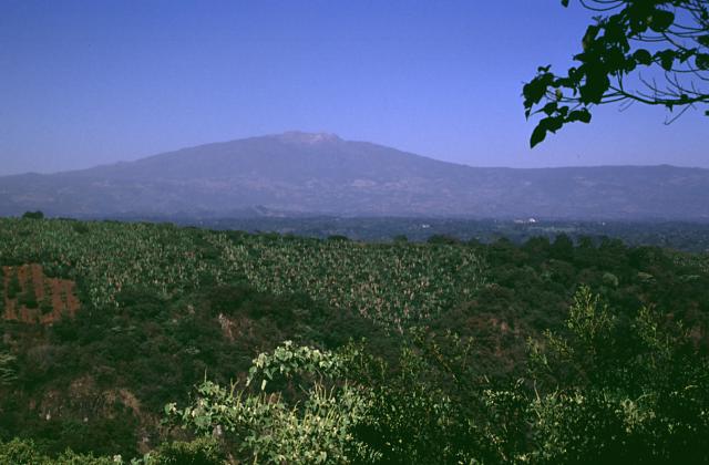
Orizaba, Pico de is a stratovolcano rising to 5,564 meters (18,255 feet) in Mexico's Middle America-Caribbean Volcanic Regions. Its last known eruption was in 1846 CE. The volcano has produced 20 recorded eruptions, with a maximum Volcanic Explosivity Index (VEI) of 4.
Geography & Climate
Orizaba, Pico de is located in Mexico, within the Trans-Mexican Volcanic Arc of the broader Middle America-Caribbean Volcanic Regions. Situated at 19.03° N, 97.27° W in the Northern Hemisphere, the volcano lies within a tropical climate zone. At 5,564 meters above sea level, Orizaba, Pico de reaches well into the permanent snow and ice zone. Glaciers and snowpack on the upper slopes create the potential for lahars — destructive volcanic mudflows — during eruptions, as heat rapidly melts ice and snow. The volcanic landform is characterized as a composite, which describes the physical shape and structure of the volcanic edifice as observed from the surface.
Geological Context
Orizaba, Pico de sits in a subduction zone, where one tectonic plate dives beneath another, creating intense heat and pressure that generates magma. Subduction zones are responsible for many of the world's most explosive volcanoes and deadliest eruptions. For communities in Mexico near Orizaba, Pico de, this tectonic setting means the volcano is capable of producing powerful explosive eruptions, pyroclastic flows, and lahars that can threaten populated areas within tens of kilometers of the summit. The dominant rock type is andesite / basaltic andesite, a dark, fine-grained volcanic rock that forms from rapidly cooling, low-viscosity lava. Basaltic eruptions tend to be less explosive and produce fluid lava flows that can travel long distances. While less immediately dangerous than explosive eruptions, basaltic lava flows can destroy structures and infrastructure in their path, and volcanic gases released during these eruptions can affect air quality over a wide area.
Eruption History Summary
Orizaba, Pico de has 20 recorded eruptions in the geological database, spanning from 2300 BCE to 1846 CE. The most powerful recorded event was a cataclysmic eruption with ash columns reaching the stratosphere in 2300 BCE, reaching VEI 4 on the Volcanic Explosivity Index. Notable eruptions include 1260 CE (VEI 3), 1175 CE (VEI 3), 220 CE (VEI 3). With an average interval of roughly 207 years between eruptions over a span of 4,146 years, this is one of the more frequently active volcanoes in the database. This persistent activity suggests a robust and well-supplied magma system beneath the volcano.
Significance
With a maximum recorded VEI of 4, Orizaba, Pico de has demonstrated the capacity for significant explosive eruptions that can impact regional aviation, agriculture, and communities tens of kilometers from the summit. VEI 4 eruptions produce ash columns reaching 15-25 kilometers into the atmosphere. Its 20 recorded eruptions make it one of the most prolific volcanoes in our database, reflecting a persistent and well-documented eruptive history that has provided volcanologists with extensive data for understanding eruption patterns and forecasting future activity.
GVP Reference Summary
Pico de Orizaba (Volcán Citlaltépetl), México's highest peak and North America's highest volcano, was formed in three stages beginning during the mid-Pleistocene. Orizaba lies at the southern end of a volcanic chain extending north to Cofre de Perote volcano and towers up to 4400 m above its eastern base. Construction of the initial Torrecillas and Espolón de Oro volcanoes was contemporaneous with growth of Sierra Negra volcano on the SW flank and was followed by edifice collapses that produced voluminous debris avalanches and lahars. The modern volcano was constructed during the late Pleistocene and Holocene of viscous andesitic and dacitic lavas, forming the current steep-sided cone. Repetitive explosive eruptions beginning during the early Holocene accompanied lava dome growth and lava effusion. Historical eruptions have consisted of moderate explosive activity and the effusion of dacitic lava flows. The latest eruption occurred during the 19th century.
— Smithsonian Institution, Global Volcanism Program
20 Recorded Eruptions
| Year | VEI | Type | Area |
|---|---|---|---|
| 1846 | 2 | Confirmed Eruption | — |
| 1687 | 2 | Confirmed Eruption | — |
| 1613 | 0 | Confirmed Eruption | — |
| 1569 | 2 | Confirmed Eruption | — |
| 1566 | 2 | Confirmed Eruption | — |
| 1545 | 2 | Confirmed Eruption | — |
| 1533 | 2 | Uncertain Eruption | — |
| 1351 | 2 | Uncertain Eruption | — |
| 1260 | 3 | Confirmed Eruption | — |
| 1187 | 2 | Uncertain Eruption | — |
| 1175 | 3 | Confirmed Eruption | — |
| 1157 | 2 | Uncertain Eruption | — |
| 220 | 3 | Confirmed Eruption | — |
| 140 | 3 | Confirmed Eruption | — |
| 90 | 3 | Confirmed Eruption | — |
| 40 | 3 | Confirmed Eruption | — |
| 780 BCE | 3 | Confirmed Eruption | — |
| 1500 BCE | 3 | Confirmed Eruption | — |
| 2110 BCE | 3 | Confirmed Eruption | — |
| 2300 BCE | 4 | Confirmed Eruption | — |
Real-Time Data
Frequently Asked Questions About Orizaba, Pico de
Is Orizaba, Pico de an active volcano?+
Orizaba, Pico de is classified as active based on credible evidence of past eruptions. Although its last known eruption was in 1846 CE, volcanologists consider it capable of erupting again.
When did Orizaba, Pico de last erupt?+
The most recent recorded eruption of Orizaba, Pico de occurred in 1846 CE with a Volcanic Explosivity Index (VEI) of 2. The eruption was classified as a "Confirmed Eruption." Orizaba, Pico de has 20 recorded eruptions in total.
How high is Orizaba, Pico de?+
Orizaba, Pico de has a summit elevation of 5,564 meters (18,255 feet) above sea level. At 5,564 meters, it stands taller than Mount Rainier (4,392m) and is among the world's major volcanic peaks.
What type of volcano is Orizaba, Pico de?+
Orizaba, Pico de is classified as a Stratovolcano. Stratovolcanoes (also called composite volcanoes) are steep, conical volcanoes built up by many layers of hardened lava, tephra, and volcanic ash. They are among the most common and dangerous types, known for explosive eruptions.
Where is Orizaba, Pico de located?+
Orizaba, Pico de is located in Mexico, in the Middle America-Caribbean Volcanic Regions. More specifically, it lies within the Trans-Mexican Volcanic Arc. Its exact coordinates are 19.030° latitude, -97.270° longitude.
Is it safe to visit Orizaba, Pico de?+
Orizaba, Pico de can generally be visited, but as with any volcano, visitors should check local conditions and any advisory notices before traveling. Mexico may have specific regulations for accessing volcanic areas. Guided tours are often the safest and most informative way to experience a volcano.