About Cumbres, Las
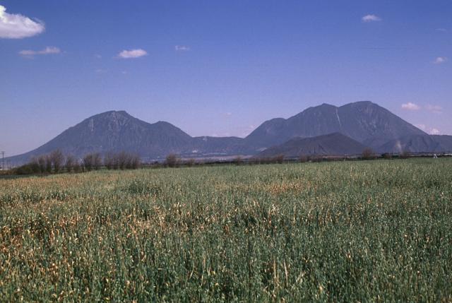
Cumbres, Las is a stratovolcano rising to 3,940 meters (12,927 feet) in Mexico's Middle America-Caribbean Volcanic Regions. The volcano is currently active, with its most recent eruption in 3920 BCE. The volcano has produced 1 recorded eruption.
Geography & Climate
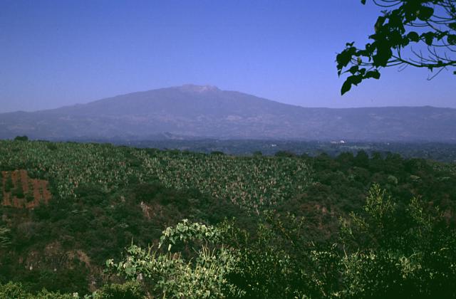
Cumbres, Las is located in Mexico, within the Trans-Mexican Volcanic Arc of the broader Middle America-Caribbean Volcanic Regions. Situated at 19.15° N, 97.27° W in the Northern Hemisphere, the volcano lies within a tropical climate zone. Standing at 3,940 meters above sea level, Cumbres, Las towers above the alpine zone, where vegetation gives way to bare rock, snow, and ice for much of the year. The high elevation means the upper slopes experience significantly colder temperatures than surrounding lowlands. The volcanic landform is characterized as a composite, which describes the physical shape and structure of the volcanic edifice as observed from the surface.
Geological Context
Cumbres, Las sits in a subduction zone, where one tectonic plate dives beneath another, creating intense heat and pressure that generates magma. Subduction zones are responsible for many of the world's most explosive volcanoes and deadliest eruptions. For communities in Mexico near Cumbres, Las, this tectonic setting means the volcano is capable of producing powerful explosive eruptions, pyroclastic flows, and lahars that can threaten populated areas within tens of kilometers of the summit. The dominant rock type is andesite / basaltic andesite, a dark, fine-grained volcanic rock that forms from rapidly cooling, low-viscosity lava. Basaltic eruptions tend to be less explosive and produce fluid lava flows that can travel long distances. While less immediately dangerous than explosive eruptions, basaltic lava flows can destroy structures and infrastructure in their path, and volcanic gases released during these eruptions can affect air quality over a wide area.
Eruption History Summary
Cumbres, Las has 1 recorded eruption in the geological database, spanning from 3920 BCE to 3920 BCE.
GVP Reference Summary
The Las Cumbres volcanic complex, a Quaternary center about 15 km NNE of Pico de Orizaba, contains a 3.5-4.5 km wide summit caldera narrowly breached on the east side. A dacitic lava dome (Cerro Gordo or El Cumbre Grande) lies in the center of the caldera. A group of monogenetic cones, explosion craters, and andesitic and rhyolitic lava domes is located north and south of Cerro las Cumbres. Three of these, Xalista and El Rodeo to the north, and Ixetal to the south, are obsidian domes. A major rhyolitic explosive eruption producing the Quetzalapa Pumice about 20,000 years ago originated from a vent on the lower NW flank of the Las Cumbres complex. Eruptive activity at the main Las Cumbres complex ceased during the late Pleistocene, although activity on the flanks of the edifice continued into the Holocene. The rhyolitic Yolotepec lava dome, north of Las Cumbres, has been radiocarbon dated at about 5900 years before present.
— Smithsonian Institution, Global Volcanism Program
1 Recorded Eruption
| Year | VEI | Type | Area |
|---|---|---|---|
| 3920 BCE | — | Confirmed Eruption | North flank (Yolotepec lava dome) |
Real-Time Data
Frequently Asked Questions About Cumbres, Las
Is Cumbres, Las an active volcano?+
Cumbres, Las is not currently classified as active. Its activity evidence is listed as "Eruption Dated." The last known eruption was in 3920 BCE. However, no volcano is ever considered permanently extinct.
When did Cumbres, Las last erupt?+
The most recent recorded eruption of Cumbres, Las occurred in 3920 BCE. The eruption was classified as a "Confirmed Eruption." Cumbres, Las has 1 recorded eruption in total.
How high is Cumbres, Las?+
Cumbres, Las has a summit elevation of 3,940 meters (12,927 feet) above sea level. At 3,940 meters, it is comparable in height to many significant mountain peaks and stands well above the tree line.
What type of volcano is Cumbres, Las?+
Cumbres, Las is classified as a Stratovolcano. Stratovolcanoes (also called composite volcanoes) are steep, conical volcanoes built up by many layers of hardened lava, tephra, and volcanic ash. They are among the most common and dangerous types, known for explosive eruptions.
Where is Cumbres, Las located?+
Cumbres, Las is located in Mexico, in the Middle America-Caribbean Volcanic Regions. More specifically, it lies within the Trans-Mexican Volcanic Arc. Its exact coordinates are 19.150° latitude, -97.270° longitude.
Is it safe to visit Cumbres, Las?+
Cumbres, Las can generally be visited, but as with any volcano, visitors should check local conditions and any advisory notices before traveling. Mexico may have specific regulations for accessing volcanic areas. Guided tours are often the safest and most informative way to experience a volcano.