About Prieto, Cerro
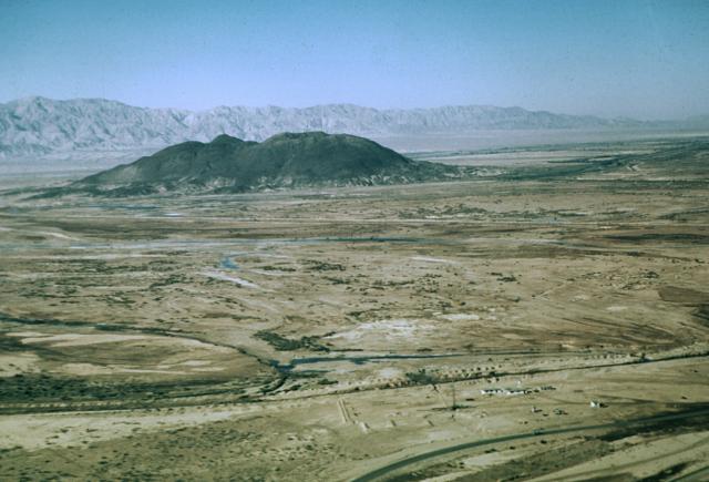
Prieto, Cerro is a lava dome rising to 223 meters (732 feet) in Mexico's Eastern Pacific Volcanic Regions. No historical eruptions have been recorded, though the volcano is classified based on geological evidence of past activity.
Geography & Climate
Prieto, Cerro is located in Mexico, within the Gulf of California Rift Volcanic Province of the broader Eastern Pacific Volcanic Regions. Situated at 32.42° N, 115.31° W in the Northern Hemisphere, the volcano lies within a subtropical climate zone. At just 223 meters above sea level, Prieto, Cerro is a relatively low-elevation volcanic feature. Despite its modest height, it remains an active geological formation with the same underlying magmatic processes as its taller counterparts. The volcanic landform is characterized as a minor, which describes the physical shape and structure of the volcanic edifice as observed from the surface.
Geological Context
Prieto, Cerro is situated along a rift zone, where tectonic plates are pulling apart. As the crust thins and fractures, magma rises to fill the gap, creating volcanic activity. Rift volcanism typically produces more fluid lava flows rather than explosive blasts, which means communities near Prieto, Cerro in Mexico generally face slower-moving hazards like lava flows and ground fissures rather than sudden pyroclastic events. However, rift volcanoes can still generate significant ash emissions and gas releases that affect local air quality. The dominant rock type is dacite, an intermediate to silica-rich volcanic rock. This composition typically produces more viscous magma, leading to more explosive eruptions with ash columns and pyroclastic flows. Andesitic and dacitic magmas build pressure before erupting, which is why volcanoes with this rock chemistry are often associated with Plinian-style eruptions that can send ash tens of kilometers into the atmosphere and disrupt aviation across entire regions.
GVP Reference Summary
The Cerro Prieto geothermal field is located at the head of the Gulf of California, 35 km south of the city of Mexicali. Cerro Prieto lies in an active continental rift that is transitional between the transform San Andreas fault system to the north and a spreading ridge of the East Pacific Rise in the Gulf of California to the south. The only surficial volcanic feature at Cerro Prieto, which is located near sea level on the Colorado River delta, is a small, 223-m-high compound dacitic lava dome. A 200-m-wide crater is located at the summit of the NE-most dome. The Cerro Prieto dome was roughly estimated from paleomagnetic evidence to have formed during a series of events between 100,000 and 10,000 years ago. Cucupas Indian legends described a monster that covered the land with hot rocks, which grew through the soil and emitted fire tongues, a possible reference to the growth of the volcano.
— Smithsonian Institution, Global Volcanism Program
0 Recorded Eruptions
No eruption records available for Prieto, Cerro.
Real-Time Data
Frequently Asked Questions About Prieto, Cerro
Is Prieto, Cerro an active volcano?+
Prieto, Cerro is not currently classified as active. Its activity evidence is listed as "Evidence Uncertain." No recorded eruptions have been documented. However, no volcano is ever considered permanently extinct.
How high is Prieto, Cerro?+
Prieto, Cerro has a summit elevation of 223 meters (732 feet) above sea level. At 223 meters, it is a relatively low-elevation volcano.
What type of volcano is Prieto, Cerro?+
Prieto, Cerro is classified as a Lava dome. Lava dome volcanoes have distinct geological characteristics that set them apart from other volcanic types.
Where is Prieto, Cerro located?+
Prieto, Cerro is located in Mexico, in the Eastern Pacific Volcanic Regions. More specifically, it lies within the Gulf of California Rift Volcanic Province. Its exact coordinates are 32.418° latitude, -115.305° longitude.
Is it safe to visit Prieto, Cerro?+
Prieto, Cerro can generally be visited, but as with any volcano, visitors should check local conditions and any advisory notices before traveling. Mexico may have specific regulations for accessing volcanic areas. Guided tours are often the safest and most informative way to experience a volcano.

