Salton Buttes
Lava dome(s) · -40m · United States
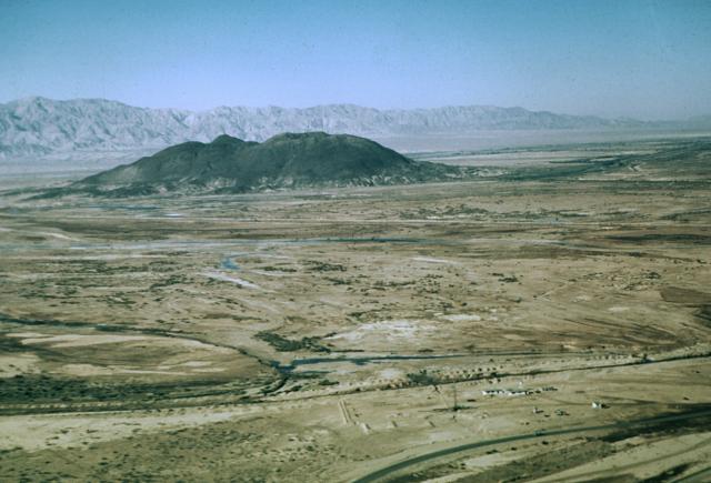
About Salton Buttes
Salton Buttes is a lava dome(s) rising to -40 meters (-131 feet) in United States's Eastern Pacific Volcanic Regions. Its last known eruption was in 210 CE. The volcano has produced 3 recorded eruptions.
Geography & Climate
Salton Buttes is located in United States, within the Gulf of California Rift Volcanic Province of the broader Eastern Pacific Volcanic Regions. Situated at 33.20° N, 115.62° W in the Northern Hemisphere, the volcano lies within a subtropical climate zone. With an elevation of -40 meters — below sea level — Salton Buttes is a submarine or submerged volcanic feature. Submarine volcanoes make up the majority of Earth's volcanic activity, though most eruptions go unobserved beneath the ocean surface. The volcanic landform is characterized as a minor (silicic), which describes the physical shape and structure of the volcanic edifice as observed from the surface.
Geological Context
Salton Buttes is situated along a rift zone, where tectonic plates are pulling apart. As the crust thins and fractures, magma rises to fill the gap, creating volcanic activity. Rift volcanism typically produces more fluid lava flows rather than explosive blasts, which means communities near Salton Buttes in United States generally face slower-moving hazards like lava flows and ground fissures rather than sudden pyroclastic events. However, rift volcanoes can still generate significant ash emissions and gas releases that affect local air quality. The dominant rock type is rhyolite, a silica-rich volcanic rock associated with highly viscous magma. Rhyolitic eruptions can be extremely explosive and are responsible for some of the largest volcanic events in Earth's history, including supervolcanic caldera-forming eruptions. The high silica content traps dissolved gases, building enormous pressure that can lead to catastrophic explosive releases.
Eruption History Summary
Salton Buttes has 3 recorded eruptions in the geological database, spanning from 290 BCE to 210 CE. These eruptions span roughly 500 years of volcanic history.
GVP Reference Summary
The Salton Buttes consist of five small rhyolitic lava domes extruded onto Quaternary sediments of the Colorado River delta at the SE margin of the Salton Sea. Their age has variously been considered to be late Pleistocene or early Holocene based on different dating techniques. Recent paleomagnetic dating calibrated by radiocarbon ages suggests that the domes were erupted during an interval of about 500 years between about 2,300 and 1,800 years ago, with the possible exception of Mullet Island at the northern end of the field, which could be as much as 5,000 years older. The present-day saline Salton Sea was formed in the early 20th century by unintended flooding into the basin formerly occupied by Pleistocene Lake Cahuilla Lake during diversion of the Colorado River for irrigation purposes. The Salton Sea geothermal field produces saline brines.
— Smithsonian Institution, Global Volcanism Program
3 Recorded Eruptions
| Year | VEI | Type | Area |
|---|---|---|---|
| 210 | — | Confirmed Eruption | Rock Hill, N & S Red Hill |
| 10 | — | Confirmed Eruption | Obsidian Butte |
| 290 BCE | — | Confirmed Eruption | Mullet Island |
Real-Time Data
Frequently Asked Questions About Salton Buttes
Is Salton Buttes an active volcano?+
Salton Buttes is not currently classified as active. Its activity evidence is listed as "Eruption Dated." The last known eruption was in 210 CE. However, no volcano is ever considered permanently extinct.
When did Salton Buttes last erupt?+
The most recent recorded eruption of Salton Buttes occurred in 210 CE. The eruption was classified as a "Confirmed Eruption." Salton Buttes has 3 recorded eruptions in total.
How high is Salton Buttes?+
Salton Buttes has a summit elevation of -40 meters (-131 feet) above sea level. With an elevation of -40 meters (below sea level), this is a submarine or submerged volcanic feature.
What type of volcano is Salton Buttes?+
Salton Buttes is classified as a Lava dome(s). Lava domes are mounds of viscous lava that pile up around a volcanic vent. They grow by expansion from within and can collapse to produce dangerous pyroclastic flows.
Where is Salton Buttes located?+
Salton Buttes is located in United States, in the Eastern Pacific Volcanic Regions. More specifically, it lies within the Gulf of California Rift Volcanic Province. Its exact coordinates are 33.197° latitude, -115.616° longitude.
Is it safe to visit Salton Buttes?+
Salton Buttes can generally be visited, but as with any volcano, visitors should check local conditions and any advisory notices before traveling. United States may have specific regulations for accessing volcanic areas. Guided tours are often the safest and most informative way to experience a volcano.