San Quintin Volcanic Field
Pyroclastic cone(s) · 260m · Mexico
About San Quintin Volcanic Field
San Quintin Volcanic Field is a pyroclastic cone(s) rising to 260 meters (853 feet) in Mexico's Eastern Pacific Volcanic Regions. No historical eruptions have been recorded, though the volcano is classified based on geological evidence of past activity.
Geography & Climate
San Quintin Volcanic Field is located in Mexico, within the Gulf of California Rift Volcanic Province of the broader Eastern Pacific Volcanic Regions. Situated at 30.47° N, 116.01° W in the Northern Hemisphere, the volcano lies within a subtropical climate zone. At just 260 meters above sea level, San Quintin Volcanic Field is a relatively low-elevation volcanic feature. Despite its modest height, it remains an active geological formation with the same underlying magmatic processes as its taller counterparts. The volcanic landform is characterized as a cluster, which describes the physical shape and structure of the volcanic edifice as observed from the surface.
GVP Reference Summary
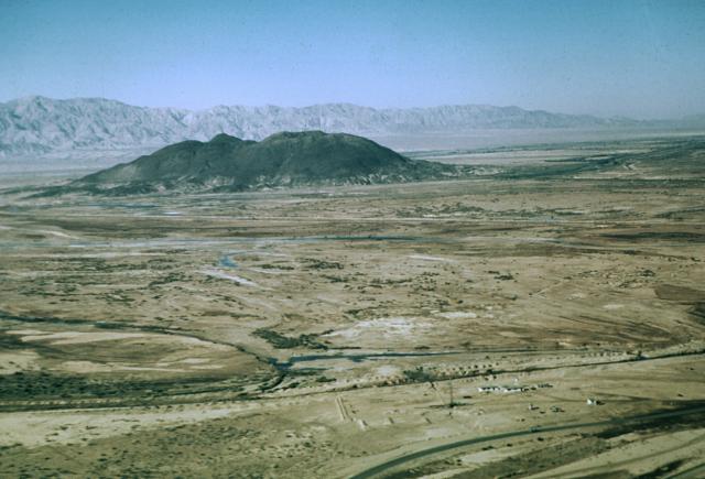
San Quintín Volcanic Field on the NW coast of Baja California consists of 11 late-Pleistocene pyroclastic cones and related lava flows. Low lava shields, initially submarine, are capped by scoria cones. San Quintín rocks are similar to intraplate or oceanic island alkalic rocks and differ from other Baja alkalic volcanic suites. It is the only Quaternary volcanic field in Baja California where lower-crustal and upper-mantle xenoliths are found. The field is located at the margins of the Y-shaped San Quintín Bay, and includes a northern and southern group of cones, Monte Mazo (connected to the mainland by a long tombolo), and Isla San Martín (5 km offshore to the west). Lava flows overlie midden deposits thought to be 5-6,000 years old, and Gastil et al. (1975) also considered the southern cones of Picacho Vizcaino and Sudoeste to possibly be less than 3,000 years old. However, Ar-Ar dating (Ortega-Rivera et al., 2004) restricted eruptions to a range of about 180,000 to 20,000 years ago.
— Smithsonian Institution, Global Volcanism Program
0 Recorded Eruptions
No eruption records available for San Quintin Volcanic Field.
Real-Time Data
Frequently Asked Questions About San Quintin Volcanic Field
Is San Quintin Volcanic Field an active volcano?+
San Quintin Volcanic Field is not currently classified as active. Its activity evidence is listed as "unknown." No recorded eruptions have been documented. However, no volcano is ever considered permanently extinct.
How high is San Quintin Volcanic Field?+
San Quintin Volcanic Field has a summit elevation of 260 meters (853 feet) above sea level. At 260 meters, it is a relatively low-elevation volcano.
What type of volcano is San Quintin Volcanic Field?+
San Quintin Volcanic Field is classified as a Pyroclastic cone(s). Pyroclastic cones (or cinder cones) are small, steep-sided volcanic cones built from fragments of lava blasted into the air. They are the simplest type of volcano and often form in groups.
Where is San Quintin Volcanic Field located?+
San Quintin Volcanic Field is located in Mexico, in the Eastern Pacific Volcanic Regions. More specifically, it lies within the Gulf of California Rift Volcanic Province. Its exact coordinates are 30.467° latitude, -116.012° longitude.
Is it safe to visit San Quintin Volcanic Field?+
San Quintin Volcanic Field can generally be visited, but as with any volcano, visitors should check local conditions and any advisory notices before traveling. Mexico may have specific regulations for accessing volcanic areas. Guided tours are often the safest and most informative way to experience a volcano.