About Crater Lake
Crater Lake is a caldera rising to 2,487 meters (8,160 feet) in United States's North America Volcanic Regions. The volcano is currently active, with its most recent eruption in 2850 BCE. The volcano has produced 5 recorded eruptions, with a maximum Volcanic Explosivity Index (VEI) of 7.
Geography & Climate
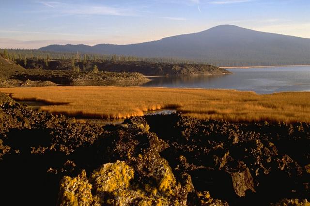
Crater Lake is located in United States, within the High Cascades Volcanic Arc of the broader North America Volcanic Regions. Situated at 42.94° N, 122.11° W in the Northern Hemisphere, the volcano lies within a temperate climate zone. At 2,487 meters above sea level, Crater Lake rises above the surrounding terrain into montane or subalpine conditions. The elevation creates distinct ecological zones along its flanks, from forested lower slopes to exposed rocky terrain near the summit. The volcanic landform is characterized as a caldera, which describes the physical shape and structure of the volcanic edifice as observed from the surface.
Geological Context
Crater Lake sits in a subduction zone, where one tectonic plate dives beneath another, creating intense heat and pressure that generates magma. Subduction zones are responsible for many of the world's most explosive volcanoes and deadliest eruptions. For communities in United States near Crater Lake, this tectonic setting means the volcano is capable of producing powerful explosive eruptions, pyroclastic flows, and lahars that can threaten populated areas within tens of kilometers of the summit. The dominant rock type is dacite, an intermediate to silica-rich volcanic rock. This composition typically produces more viscous magma, leading to more explosive eruptions with ash columns and pyroclastic flows. Andesitic and dacitic magmas build pressure before erupting, which is why volcanoes with this rock chemistry are often associated with Plinian-style eruptions that can send ash tens of kilometers into the atmosphere and disrupt aviation across entire regions.
Eruption History Summary
Crater Lake has 5 recorded eruptions in the geological database, spanning from 5900 BCE to 2850 BCE. The most powerful recorded event was a super-colossal eruption, among the largest in recorded geological history in 5680 BCE, reaching VEI 7 on the Volcanic Explosivity Index. Notable eruptions include 5680 BCE (VEI 7), 5900 BCE (VEI 6). This eruption frequency indicates a moderately active volcanic system with periodic reawakenings.
Significance
Crater Lake has produced at least one eruption of VEI 7 or higher, placing it among the most powerful volcanic systems ever documented on Earth. Eruptions of this magnitude eject hundreds of cubic kilometers of material, can cause volcanic winters lasting years, and have historically led to crop failures and famine across continents. With 5 recorded eruptions on file, Crater Lake has enough documented activity to help scientists identify patterns in its eruptive behavior.
GVP Reference Summary
The spectacular 8 x 10 km Crater Lake caldera in the southern Cascades of Oregon formed about 7,700 years ago as a result of the collapse of a complex of overlapping shield and stratovolcanoes known as Mount Mazama. The cone-building stage, during which at least five andesitic and dacitic shields and stratovolcanoes were constructed, took place between about 420 and 40 thousand years ago (ka). A series of rhyodacitic lava domes and flows and associated pyroclastic rocks were erupted between about 30 ka and the climactic eruption. The explosive eruptions triggering collapse of the 8-10 km wide caldera about 7500 years ago were among Earth's largest known Holocene eruptions, distributing tephra as far away as Canada and producing pyroclastic flows that traveled 40 km from the volcano. A 5-km-wide ring fracture zone is thought to mark the original collapse diameter. The deep blue waters of North America's second deepest lake, at 600 m, fill the caldera to within 150-600 m of its rim. Post-caldera eruptions within a few hundred years of caldera formation constructed a series of small lava domes on the caldera floor, including the partially subaerial Wizard Island cinder cone, and the completely submerged Merriam Cone. The latest eruptions produced a small rhyodacitic lava dome beneath the lake surface east of Wizard Island about 4,200 years ago.
— Smithsonian Institution, Global Volcanism Program
5 Recorded Eruptions
| Year | VEI | Type | Area |
|---|---|---|---|
| 2850 BCE | — | Confirmed Eruption | Lava dome ENE of Wizard Island |
| 5250 BCE | — | Confirmed Eruption | Wizard Island and Merriam Cone |
| 5550 BCE | 0 | Confirmed Eruption | Central Platform |
| 5680 BCE | 7 | Confirmed Eruption | Mt. Mazama summit and flank vents |
| 5900 BCE | 6 | Confirmed Eruption | North flank (Llao Rock) |
Real-Time Data
Frequently Asked Questions About Crater Lake
Is Crater Lake an active volcano?+
Crater Lake is not currently classified as active. Its activity evidence is listed as "Eruption Dated." The last known eruption was in 2850 BCE. However, no volcano is ever considered permanently extinct.
When did Crater Lake last erupt?+
The most recent recorded eruption of Crater Lake occurred in 2850 BCE. The eruption was classified as a "Confirmed Eruption." Crater Lake has 5 recorded eruptions in total.
How high is Crater Lake?+
Crater Lake has a summit elevation of 2,487 meters (8,160 feet) above sea level. At 2,487 meters, it is comparable in height to many significant mountain peaks and stands well above the tree line.
What type of volcano is Crater Lake?+
Crater Lake is classified as a Caldera. Calderas are large volcanic depressions formed when a volcano erupts so powerfully that its magma chamber collapses, creating a basin that can be kilometers wide. They are often sites of some of Earth's largest eruptions.
Where is Crater Lake located?+
Crater Lake is located in United States, in the North America Volcanic Regions. More specifically, it lies within the High Cascades Volcanic Arc. Its exact coordinates are 42.942° latitude, -122.107° longitude.
Is it safe to visit Crater Lake?+
Crater Lake can generally be visited, but as with any volcano, visitors should check local conditions and any advisory notices before traveling. United States may have specific regulations for accessing volcanic areas. Guided tours are often the safest and most informative way to experience a volcano.