About Cinnamon Butte
Cinnamon Butte is a pyroclastic cone(s) rising to 1,958 meters (6,424 feet) in United States's North America Volcanic Regions. No historical eruptions have been recorded, though the volcano is classified based on geological evidence of past activity.
Geography & Climate
Cinnamon Butte is located in United States, within the High Cascades Volcanic Arc of the broader North America Volcanic Regions. Situated at 43.24° N, 122.11° W in the Northern Hemisphere, the volcano lies within a temperate climate zone. With a summit elevation of 1,958 meters above sea level, Cinnamon Butte is a moderately sized peak that remains accessible to hikers and researchers for much of the year. The volcanic landform is characterized as a minor (basaltic), which describes the physical shape and structure of the volcanic edifice as observed from the surface.
Geological Context
Cinnamon Butte sits in a subduction zone, where one tectonic plate dives beneath another, creating intense heat and pressure that generates magma. Subduction zones are responsible for many of the world's most explosive volcanoes and deadliest eruptions. For communities in United States near Cinnamon Butte, this tectonic setting means the volcano is capable of producing powerful explosive eruptions, pyroclastic flows, and lahars that can threaten populated areas within tens of kilometers of the summit. The dominant rock type is basalt / picro-basalt, a dark, fine-grained volcanic rock that forms from rapidly cooling, low-viscosity lava. Basaltic eruptions tend to be less explosive and produce fluid lava flows that can travel long distances. While less immediately dangerous than explosive eruptions, basaltic lava flows can destroy structures and infrastructure in their path, and volcanic gases released during these eruptions can affect air quality over a wide area.
GVP Reference Summary
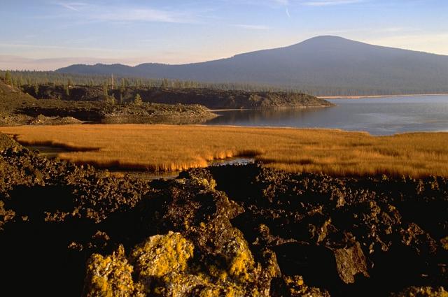
Cinnamon Butte, Thirsty Point, and Kelsay Point are forested cinder cones along a WNW-ESE line immediately west of the Cascade crest and NE of Diamond Lake. The cones have well-preserved summit craters, and lava flows appear to be unglaciated, suggesting they are younger than 11,000 years (Sherrod, 1991). Lava flows from Cinnamon Butte pass through gaps of late-Pleistocene moraines, although all three cones are covered by the roughly 6,845-year-old Mazama Ash associated with the formation of Crater Lake caldera (~30 km S). Other Pleistocene cinder cones and a lava dome are located nearby, mostly west of the Cascade Range crest.
— Smithsonian Institution, Global Volcanism Program
0 Recorded Eruptions
No eruption records available for Cinnamon Butte.
Real-Time Data
Frequently Asked Questions About Cinnamon Butte
Is Cinnamon Butte an active volcano?+
Cinnamon Butte is not currently classified as active. Its activity evidence is listed as "Evidence Uncertain." No recorded eruptions have been documented. However, no volcano is ever considered permanently extinct.
How high is Cinnamon Butte?+
Cinnamon Butte has a summit elevation of 1,958 meters (6,424 feet) above sea level. At 1,958 meters, it is a moderately sized volcanic peak, roughly comparable to Mount Vesuvius (1,281m).
What type of volcano is Cinnamon Butte?+
Cinnamon Butte is classified as a Pyroclastic cone(s). Pyroclastic cones (or cinder cones) are small, steep-sided volcanic cones built from fragments of lava blasted into the air. They are the simplest type of volcano and often form in groups.
Where is Cinnamon Butte located?+
Cinnamon Butte is located in United States, in the North America Volcanic Regions. More specifically, it lies within the High Cascades Volcanic Arc. Its exact coordinates are 43.241° latitude, -122.111° longitude.
Is it safe to visit Cinnamon Butte?+
Cinnamon Butte can generally be visited, but as with any volcano, visitors should check local conditions and any advisory notices before traveling. United States may have specific regulations for accessing volcanic areas. Guided tours are often the safest and most informative way to experience a volcano.