About Davis Lake
Davis Lake is a volcanic field rising to 2,163 meters (7,097 feet) in United States's North America Volcanic Regions. The volcano is currently active, with its most recent eruption in 2790 BCE. The volcano has produced 1 recorded eruption.
Geography & Climate
Davis Lake is located in United States, within the High Cascades Volcanic Arc of the broader North America Volcanic Regions. Situated at 43.57° N, 121.82° W in the Northern Hemisphere, the volcano lies within a temperate climate zone. At 2,163 meters above sea level, Davis Lake rises above the surrounding terrain into montane or subalpine conditions. The elevation creates distinct ecological zones along its flanks, from forested lower slopes to exposed rocky terrain near the summit. The volcanic landform is characterized as a cluster, which describes the physical shape and structure of the volcanic edifice as observed from the surface.
Geological Context
Davis Lake sits in a subduction zone, where one tectonic plate dives beneath another, creating intense heat and pressure that generates magma. Subduction zones are responsible for many of the world's most explosive volcanoes and deadliest eruptions. For communities in United States near Davis Lake, this tectonic setting means the volcano is capable of producing powerful explosive eruptions, pyroclastic flows, and lahars that can threaten populated areas within tens of kilometers of the summit. The dominant rock type is andesite / basaltic andesite, a dark, fine-grained volcanic rock that forms from rapidly cooling, low-viscosity lava. Basaltic eruptions tend to be less explosive and produce fluid lava flows that can travel long distances. While less immediately dangerous than explosive eruptions, basaltic lava flows can destroy structures and infrastructure in their path, and volcanic gases released during these eruptions can affect air quality over a wide area.
Eruption History Summary
Davis Lake has 1 recorded eruption in the geological database, spanning from 2790 BCE to 2790 BCE.
GVP Reference Summary
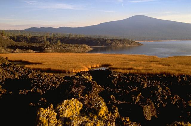
The Davis Lake area contains three andesitic Holocene cinder cones and associated fresh-looking lava flows along a N-S line at the base of a group of Pleistocene basaltic andesite shield volcanoes east of the crest of the Cascade Range, south of the Mount Bachelor volcanic chain. The northernmost lava flow created a natural barrier forming Davis Lake and lies at the western base of the Pleistocene Davis Mountain shield volcano and at the SW end of Wickiup Reservoir. The two southern flows are in a flat-lying area straddling Crescent Creek between Hamner and Odell Buttes. The middle lava flow was erupted from a small breached cinder cone on the lower southern flank of Hamner Butte and was radiocarbon dated at 4,740 years before present. The southernmost lava flow originated from a cone at the ENE base of Odell Butte. All three lava flows were probably erupted at about the same time.
— Smithsonian Institution, Global Volcanism Program
1 Recorded Eruption
| Year | VEI | Type | Area |
|---|---|---|---|
| 2790 BCE | — | Confirmed Eruption | S flank of Hamner Butte (Black Rock) |
Real-Time Data
Frequently Asked Questions About Davis Lake
Is Davis Lake an active volcano?+
Davis Lake is not currently classified as active. Its activity evidence is listed as "Eruption Dated." The last known eruption was in 2790 BCE. However, no volcano is ever considered permanently extinct.
When did Davis Lake last erupt?+
The most recent recorded eruption of Davis Lake occurred in 2790 BCE. The eruption was classified as a "Confirmed Eruption." Davis Lake has 1 recorded eruption in total.
How high is Davis Lake?+
Davis Lake has a summit elevation of 2,163 meters (7,097 feet) above sea level. At 2,163 meters, it is comparable in height to many significant mountain peaks and stands well above the tree line.
What type of volcano is Davis Lake?+
Davis Lake is classified as a Volcanic field. Volcanic fields consist of clusters of small volcanic vents and cinder cones spread across a region. Rather than a single central vent, eruptions can occur at many points across the field.
Where is Davis Lake located?+
Davis Lake is located in United States, in the North America Volcanic Regions. More specifically, it lies within the High Cascades Volcanic Arc. Its exact coordinates are 43.570° latitude, -121.820° longitude.
Is it safe to visit Davis Lake?+
Davis Lake can generally be visited, but as with any volcano, visitors should check local conditions and any advisory notices before traveling. United States may have specific regulations for accessing volcanic areas. Guided tours are often the safest and most informative way to experience a volcano.


