About Edgecumbe
Edgecumbe is a volcanic field rising to 970 meters (3,183 feet) in United States's North America Volcanic Regions. The volcano is currently active, with its most recent eruption in 2080 BCE. The volcano has produced 4 recorded eruptions.
Geography & Climate
Edgecumbe is located in United States, within the Queen Charlotte Volcano Group of the broader North America Volcanic Regions. Situated at 57.05° N, 135.75° W in the Northern Hemisphere, the volcano lies within a subarctic climate zone. With a summit elevation of 970 meters above sea level, Edgecumbe is a moderately sized peak that remains accessible to hikers and researchers for much of the year. The volcanic landform is characterized as a cluster, which describes the physical shape and structure of the volcanic edifice as observed from the surface.
Geological Context
Edgecumbe is an intraplate volcano, meaning it formed away from any plate boundary. These volcanoes are often powered by hotspots — plumes of abnormally hot mantle material rising from deep within the Earth. Hotspot volcanoes like Edgecumbe tend to produce effusive eruptions with lava flows that can be relatively predictable, giving nearby communities in United States more time to prepare. However, they can also produce explosive phases, particularly when magma interacts with groundwater. The dominant rock type is andesite / basaltic andesite, a dark, fine-grained volcanic rock that forms from rapidly cooling, low-viscosity lava. Basaltic eruptions tend to be less explosive and produce fluid lava flows that can travel long distances. While less immediately dangerous than explosive eruptions, basaltic lava flows can destroy structures and infrastructure in their path, and volcanic gases released during these eruptions can affect air quality over a wide area.
Eruption History Summary
Edgecumbe has 4 recorded eruptions in the geological database, spanning from 9300 BCE to 2360 BCE. These eruptions span roughly 6,940 years of volcanic history.
GVP Reference Summary
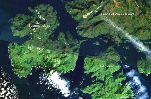
The Edgecumbe volcanic field covers about 260 km2 of Kruzov Island west of Sitka in SE Alaska. The basaltic-to-dacitic field is dominated by the large composite cones of Mount Edgecumbe, Crater Ridge, and Shell Mountain. This Pleistocene-to-Holocene system is 16 km E of the Queen Charlotte-Fairweather transform fault separating the North American and Pacific plates. Mount Edgecumbe is a stratovolcano with a well-defined crater, and is the largest edifice of the field. Crater Ridge is truncated by a 1.6-km-wide, 240-m-deep caldera. These and other vents are oriented along a SW-NE line. Volcanic activity originated about 600,000 years ago along fissures cutting Kruzof Island. A series of major silicic explosive eruptions took place about 9,000-13,000 radiocarbon years ago. The latest dated eruptions were phreatomagmatic explosions during the mid-Holocene, and all postglacial activity has been pyroclastic. Reports of observed eruptions are unsubstantiated.
— Smithsonian Institution, Global Volcanism Program
4 Recorded Eruptions
| Year | VEI | Type | Area |
|---|---|---|---|
| 2360 BCE | — | Confirmed Eruption | — |
| 3810 BCE | — | Confirmed Eruption | — |
| 7215 BCE | — | Confirmed Eruption | — |
| 9300 BCE | — | Confirmed Eruption | — |
Real-Time Data
Frequently Asked Questions About Edgecumbe
Is Edgecumbe an active volcano?+
Edgecumbe is not currently classified as active. Its activity evidence is listed as "Eruption Dated." The last known eruption was in 2080 BCE. However, no volcano is ever considered permanently extinct.
When did Edgecumbe last erupt?+
The most recent recorded eruption of Edgecumbe occurred in 2360 BCE. The eruption was classified as a "Confirmed Eruption." Edgecumbe has 4 recorded eruptions in total.
How high is Edgecumbe?+
Edgecumbe has a summit elevation of 970 meters (3,183 feet) above sea level. At 970 meters, it is a relatively low-elevation volcano.
What type of volcano is Edgecumbe?+
Edgecumbe is classified as a Volcanic field. Volcanic fields consist of clusters of small volcanic vents and cinder cones spread across a region. Rather than a single central vent, eruptions can occur at many points across the field.
Where is Edgecumbe located?+
Edgecumbe is located in United States, in the North America Volcanic Regions. More specifically, it lies within the Queen Charlotte Volcano Group. Its exact coordinates are 57.050° latitude, -135.750° longitude.
Is it safe to visit Edgecumbe?+
Edgecumbe can generally be visited, but as with any volcano, visitors should check local conditions and any advisory notices before traveling. United States may have specific regulations for accessing volcanic areas. Guided tours are often the safest and most informative way to experience a volcano.