About Buzzard Creek
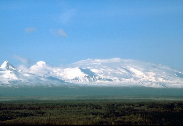
Buzzard Creek is a tuff ring(s) rising to 830 meters (2,723 feet) in United States's North America Volcanic Regions. Its last known eruption dates to 1050 BCE, in prehistoric times. The volcano has produced 1 recorded eruption, with a maximum Volcanic Explosivity Index (VEI) of 2.
Geography & Climate
Buzzard Creek is located in United States, within the Alaska Peninsula Volcanic Arc of the broader North America Volcanic Regions. Situated at 64.06° N, 148.43° W in the Northern Hemisphere, the volcano lies within a subarctic climate zone. With a summit elevation of 830 meters above sea level, Buzzard Creek is a moderately sized peak that remains accessible to hikers and researchers for much of the year. The volcanic landform is characterized as a minor (basaltic), which describes the physical shape and structure of the volcanic edifice as observed from the surface.
Geological Context
Buzzard Creek sits in a subduction zone, where one tectonic plate dives beneath another, creating intense heat and pressure that generates magma. Subduction zones are responsible for many of the world's most explosive volcanoes and deadliest eruptions. For communities in United States near Buzzard Creek, this tectonic setting means the volcano is capable of producing powerful explosive eruptions, pyroclastic flows, and lahars that can threaten populated areas within tens of kilometers of the summit. The dominant rock type is basalt / picro-basalt, a dark, fine-grained volcanic rock that forms from rapidly cooling, low-viscosity lava. Basaltic eruptions tend to be less explosive and produce fluid lava flows that can travel long distances. While less immediately dangerous than explosive eruptions, basaltic lava flows can destroy structures and infrastructure in their path, and volcanic gases released during these eruptions can affect air quality over a wide area.
Eruption History Summary
Buzzard Creek has 1 recorded eruption in the geological database, spanning from 1050 BCE to 1050 BCE. The most powerful recorded event was an explosive event producing ash plumes up to several kilometers in 1050 BCE, reaching VEI 2 on the Volcanic Explosivity Index.
GVP Reference Summary
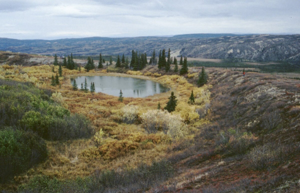
Two Holocene tuff rings form craters 300 and 66 m wide near the headwaters of Buzzard Creek at the northern foot of the central Alaska Range NE of the town of Healy along the Parks Highway. Both contain small lakes, and the smaller ring is about 200 m SE of the larger one. The total volume of ejecta, most of which is accessory material, probably does not exceed 0.001 km3. The ejecta overlies young glacial terraces that correlate with a glacial stage that ended about 10,000 years ago, and radiocarbon dates give an age for the eruption that formed the tuff rings of about 3,000 years. This minor volcanic feature lies along trend with the Aleutian arc, but is located 320 km NE of its nearest Holocene neighbor (Hayes volcano), and directly over the northernmost corner of the subducting Pacific Plate.
— Smithsonian Institution, Global Volcanism Program
1 Recorded Eruption
| Year | VEI | Type | Area |
|---|---|---|---|
| 1050 BCE | 2 | Confirmed Eruption | — |
Real-Time Data
Frequently Asked Questions About Buzzard Creek
Is Buzzard Creek an active volcano?+
Buzzard Creek is not currently classified as active. Its activity evidence is listed as "Eruption Dated." The last known eruption was in 1050 BCE. However, no volcano is ever considered permanently extinct.
When did Buzzard Creek last erupt?+
The most recent recorded eruption of Buzzard Creek occurred in 1050 BCE with a Volcanic Explosivity Index (VEI) of 2. The eruption was classified as a "Confirmed Eruption." Buzzard Creek has 1 recorded eruption in total.
How high is Buzzard Creek?+
Buzzard Creek has a summit elevation of 830 meters (2,723 feet) above sea level. At 830 meters, it is a relatively low-elevation volcano.
What type of volcano is Buzzard Creek?+
Buzzard Creek is classified as a Tuff ring(s). Tuff ring(s) volcanoes have distinct geological characteristics that set them apart from other volcanic types.
Where is Buzzard Creek located?+
Buzzard Creek is located in United States, in the North America Volcanic Regions. More specifically, it lies within the Alaska Peninsula Volcanic Arc. Its exact coordinates are 64.062° latitude, -148.433° longitude.
Is it safe to visit Buzzard Creek?+
Buzzard Creek can generally be visited, but as with any volcano, visitors should check local conditions and any advisory notices before traveling. United States may have specific regulations for accessing volcanic areas. Guided tours are often the safest and most informative way to experience a volcano.