About Kuntomintar
Kuntomintar is a stratovolcano rising to 828 meters (2,717 feet) in Russia's Northwestern Pacific Volcanic Regions. No historical eruptions have been recorded, though the volcano is classified based on geological evidence of past activity.
Geography & Climate
Kuntomintar is located in Russia, within the Kuril Volcanic Arc of the broader Northwestern Pacific Volcanic Regions. Situated at 48.75° N, 154.02° E in the Northern Hemisphere, the volcano lies within a temperate climate zone. With a summit elevation of 828 meters above sea level, Kuntomintar is a moderately sized peak that remains accessible to hikers and researchers for much of the year. The volcanic landform is characterized as a composite, which describes the physical shape and structure of the volcanic edifice as observed from the surface.
GVP Reference Summary
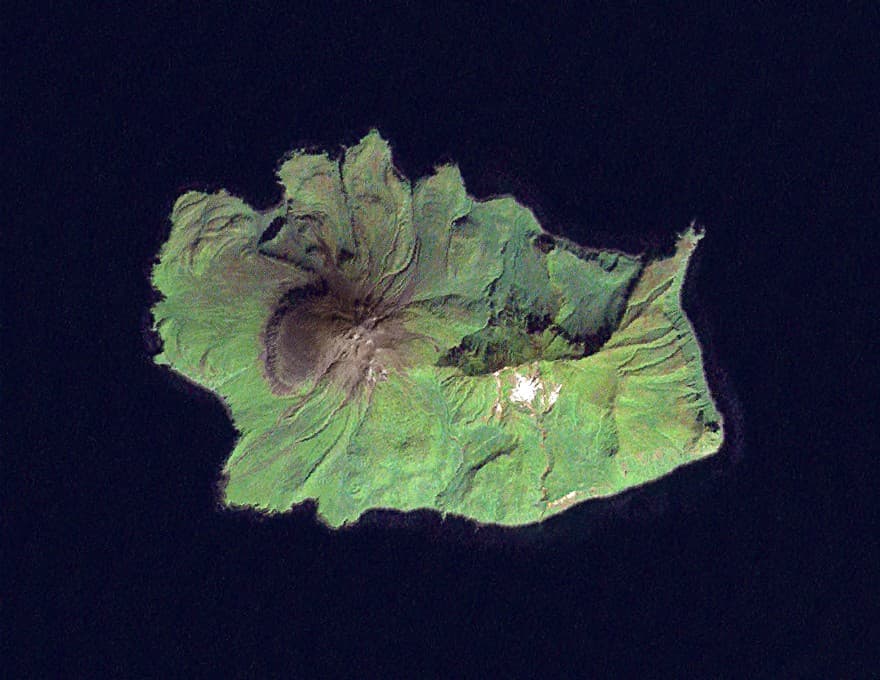
Kuntomintar is a Pleistocene andesitic stratovolcano at the southern end of Shiashkotan Island in the central Kuriles. A central cone fills a 4-4.5 km caldera, whose rim is visible on the NE side. A second caldera on the west side is breached to the west. An Ainu village that reportedly was destroyed by an eruption in 1872 was later found to be located near Sinarka volcano (Gorshkov, 1970). The only known postglacial activity is continuous solfataric activity that originates near the east wall of the inner caldera and a nearby hot sulfur spring.
— Smithsonian Institution, Global Volcanism Program
0 Recorded Eruptions
No eruption records available for Kuntomintar.
Real-Time Data
Frequently Asked Questions About Kuntomintar
Is Kuntomintar an active volcano?+
Kuntomintar is not currently classified as active. Its activity evidence is listed as "unknown." No recorded eruptions have been documented. However, no volcano is ever considered permanently extinct.
How high is Kuntomintar?+
Kuntomintar has a summit elevation of 828 meters (2,717 feet) above sea level. At 828 meters, it is a relatively low-elevation volcano.
What type of volcano is Kuntomintar?+
Kuntomintar is classified as a Stratovolcano. Stratovolcanoes (also called composite volcanoes) are steep, conical volcanoes built up by many layers of hardened lava, tephra, and volcanic ash. They are among the most common and dangerous types, known for explosive eruptions.
Where is Kuntomintar located?+
Kuntomintar is located in Russia, in the Northwestern Pacific Volcanic Regions. More specifically, it lies within the Kuril Volcanic Arc. Its exact coordinates are 48.750° latitude, 154.020° longitude.
Is it safe to visit Kuntomintar?+
Kuntomintar can generally be visited, but as with any volcano, visitors should check local conditions and any advisory notices before traveling. Russia may have specific regulations for accessing volcanic areas. Guided tours are often the safest and most informative way to experience a volcano.