About Groppo
Groppo is a volcanic field rising to 852 meters (2,795 feet) in Ethiopia's Eastern Africa Volcanic Regions. No historical eruptions have been recorded, though the volcano is classified based on geological evidence of past activity.
Geography & Climate
Groppo is located in Ethiopia, within the Afar Rift Volcanic Province of the broader Eastern Africa Volcanic Regions. Situated at 11.82° N, 40.24° E in the Northern Hemisphere, the volcano lies within a tropical climate zone. With a summit elevation of 852 meters above sea level, Groppo is a moderately sized peak that remains accessible to hikers and researchers for much of the year. The volcanic landform is characterized as a cluster, which describes the physical shape and structure of the volcanic edifice as observed from the surface.
Geological Context
Groppo is situated along a rift zone, where tectonic plates are pulling apart. As the crust thins and fractures, magma rises to fill the gap, creating volcanic activity. Rift volcanism typically produces more fluid lava flows rather than explosive blasts, which means communities near Groppo in Ethiopia generally face slower-moving hazards like lava flows and ground fissures rather than sudden pyroclastic events. However, rift volcanoes can still generate significant ash emissions and gas releases that affect local air quality.
GVP Reference Summary
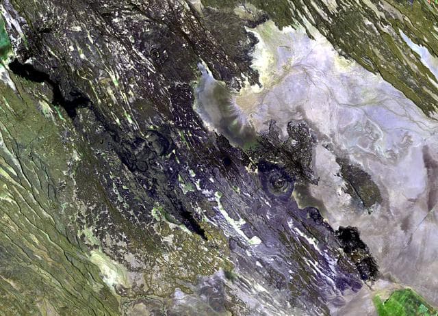
Groppo was identified by IAVCEI (1973) as a small alkali rhyolitic stratovolcano located in the western Afar near the Ethiopian escarpment, NE of Dessye. However, the nearest volcanic feature, identified in satellite imagery about 15 km NW from the given location, is a dark lava-flow field about 2.5 x 4.5 km in size, surrounding two small cones; two other smaller breached cones are nearby. The largest cone is about 300 x 500 m long, and 45 m high.
— Smithsonian Institution, Global Volcanism Program
0 Recorded Eruptions
No eruption records available for Groppo.
Real-Time Data
Frequently Asked Questions About Groppo
Is Groppo an active volcano?+
Groppo is classified as active based on credible evidence of past eruptions. Although its last known eruption was in prehistoric times, volcanologists consider it capable of erupting again.
How high is Groppo?+
Groppo has a summit elevation of 852 meters (2,795 feet) above sea level. At 852 meters, it is a relatively low-elevation volcano.
What type of volcano is Groppo?+
Groppo is classified as a Volcanic field. Volcanic fields consist of clusters of small volcanic vents and cinder cones spread across a region. Rather than a single central vent, eruptions can occur at many points across the field.
Where is Groppo located?+
Groppo is located in Ethiopia, in the Eastern Africa Volcanic Regions. More specifically, it lies within the Afar Rift Volcanic Province. Its exact coordinates are 11.816° latitude, 40.242° longitude.
Is it safe to visit Groppo?+
Groppo can generally be visited, but as with any volcano, visitors should check local conditions and any advisory notices before traveling. Ethiopia may have specific regulations for accessing volcanic areas. Guided tours are often the safest and most informative way to experience a volcano.