About Awu
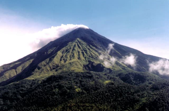
Awu is a stratovolcano rising to 1,318 meters (4,324 feet) in Indonesia's Western Pacific Volcanic Regions. It has been active in recent decades, with its last eruption in 2004 CE. The volcano has produced 19 recorded eruptions, with a maximum Volcanic Explosivity Index (VEI) of 4.
Geography & Climate
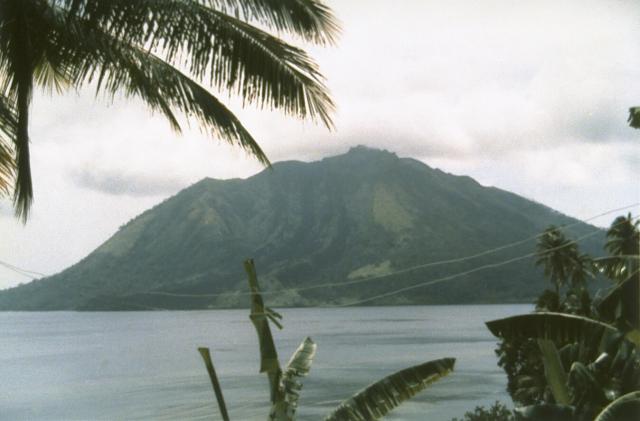
Awu is located in Indonesia, within the Sangihe Volcanic Arc of the broader Western Pacific Volcanic Regions. Situated at 3.69° N, 125.45° E in the Northern Hemisphere, the volcano lies within a tropical climate zone. With a summit elevation of 1,318 meters above sea level, Awu is a moderately sized peak that remains accessible to hikers and researchers for much of the year. The volcanic landform is characterized as a composite, which describes the physical shape and structure of the volcanic edifice as observed from the surface.
Geological Context
Awu sits in a subduction zone, where one tectonic plate dives beneath another, creating intense heat and pressure that generates magma. Subduction zones are responsible for many of the world's most explosive volcanoes and deadliest eruptions. For communities in Indonesia near Awu, this tectonic setting means the volcano is capable of producing powerful explosive eruptions, pyroclastic flows, and lahars that can threaten populated areas within tens of kilometers of the summit. The dominant rock type is andesite / basaltic andesite, a dark, fine-grained volcanic rock that forms from rapidly cooling, low-viscosity lava. Basaltic eruptions tend to be less explosive and produce fluid lava flows that can travel long distances. While less immediately dangerous than explosive eruptions, basaltic lava flows can destroy structures and infrastructure in their path, and volcanic gases released during these eruptions can affect air quality over a wide area.
Eruption History Summary
Awu has 19 recorded eruptions in the geological database, spanning from 1640 CE to 2004 CE. The most powerful recorded event was a cataclysmic eruption with ash columns reaching the stratosphere in 1966 CE, reaching VEI 4 on the Volcanic Explosivity Index. Notable eruptions include 1966 CE (VEI 4), 1892 CE (VEI 3), 1856 CE (VEI 3). This level of eruptive frequency indicates a persistently active volcanic system that warrants ongoing monitoring. With eruptive activity as recently as 2004 CE, Awu remains an actively monitored volcano.
Significance
With a maximum recorded VEI of 4, Awu has demonstrated the capacity for significant explosive eruptions that can impact regional aviation, agriculture, and communities tens of kilometers from the summit. VEI 4 eruptions produce ash columns reaching 15-25 kilometers into the atmosphere. With 19 recorded eruptions, Awu has a substantial eruptive history that provides valuable data for understanding volcanic behavior and assessing future hazards in the Western Pacific Volcanic Regions region. Given its recent activity, Awu is closely monitored by geological survey organizations to provide early warning of future unrest.
GVP Reference Summary
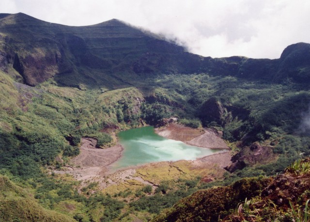
The massive Gunung Awu stratovolcano occupies the northern end of Great Sangihe Island, the largest of the Sangihe arc. Deep valleys that form passageways for lahars dissect the flanks of the volcano, which was constructed within a 4.5-km-wide caldera. Powerful explosive eruptions in 1711, 1812, 1856, 1892, and 1966 produced devastating pyroclastic flows and lahars that caused more than 8000 cumulative fatalities. Awu contained a summit crater lake that was 1 km wide and 172 m deep in 1922, but was largely ejected during the 1966 eruption.
— Smithsonian Institution, Global Volcanism Program
19 Recorded Eruptions
| Year | VEI | Type | Area |
|---|---|---|---|
| 2004 | 2 | Confirmed Eruption | — |
| 1992 | 1 | Confirmed Eruption | SE part of summit crater |
| 1968 | 2 | Uncertain Eruption | — |
| 1966 | 4 | Confirmed Eruption | — |
| 1930 | 2 | Confirmed Eruption | — |
| 1922 | 0 | Confirmed Eruption | — |
| 1921 | 0 | Confirmed Eruption | — |
| 1913 | 2 | Confirmed Eruption | — |
| 1893 | 2 | Confirmed Eruption | — |
| 1892 | 3 | Confirmed Eruption | — |
| 1885 | 2 | Confirmed Eruption | — |
| 1883 | 2 | Confirmed Eruption | — |
| 1875 | 2 | Confirmed Eruption | — |
| 1856 | 3 | Confirmed Eruption | — |
| 1812 | 4 | Confirmed Eruption | — |
| 1711 | 3 | Confirmed Eruption | — |
| 1699 | — | Uncertain Eruption | — |
| 1646 | 2 | Confirmed Eruption | — |
| 1640 | 3 | Uncertain Eruption | — |
Real-Time Data
Frequently Asked Questions About Awu
Is Awu an active volcano?+
Yes, Awu is considered an active volcano. Its most recent eruption was in 2004 CE. The volcano is monitored by geological agencies, and its activity status is based on observed eruptions within recorded history.
When did Awu last erupt?+
The most recent recorded eruption of Awu occurred in 2004 CE with a Volcanic Explosivity Index (VEI) of 2. The eruption was classified as a "Confirmed Eruption." Awu has 19 recorded eruptions in total.
How high is Awu?+
Awu has a summit elevation of 1,318 meters (4,324 feet) above sea level. At 1,318 meters, it is a moderately sized volcanic peak, roughly comparable to Mount Vesuvius (1,281m).
What type of volcano is Awu?+
Awu is classified as a Stratovolcano. Stratovolcanoes (also called composite volcanoes) are steep, conical volcanoes built up by many layers of hardened lava, tephra, and volcanic ash. They are among the most common and dangerous types, known for explosive eruptions.
Where is Awu located?+
Awu is located in Indonesia, in the Western Pacific Volcanic Regions. More specifically, it lies within the Sangihe Volcanic Arc. Its exact coordinates are 3.689° latitude, 125.447° longitude.
Is it safe to visit Awu?+
Visiting Awu requires checking current volcanic activity and alert levels. As an active volcano with eruptions as recent as 2004 CE, conditions can change rapidly. Always consult local geological authorities and follow official warnings before visiting. Many active volcanoes have designated safe viewing areas and guided tour options.