About Karangetang
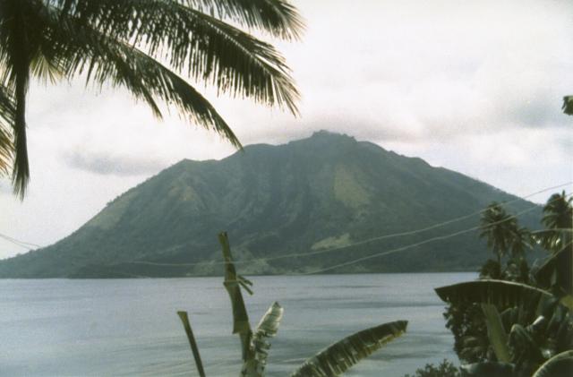
Karangetang is a stratovolcano rising to 1,797 meters (5,896 feet) in Indonesia's Western Pacific Volcanic Regions. The volcano is currently active, with its most recent eruption in 2023 CE. The volcano has produced 20 recorded eruptions, with a maximum Volcanic Explosivity Index (VEI) of 3.
Geography & Climate
Karangetang is located in Indonesia, within the Sangihe Volcanic Arc of the broader Western Pacific Volcanic Regions. Situated at 2.78° N, 125.41° E in the Northern Hemisphere, the volcano lies within a tropical climate zone. With a summit elevation of 1,797 meters above sea level, Karangetang is a moderately sized peak that remains accessible to hikers and researchers for much of the year. The volcanic landform is characterized as a composite, which describes the physical shape and structure of the volcanic edifice as observed from the surface.
Geological Context
Karangetang sits in a subduction zone, where one tectonic plate dives beneath another, creating intense heat and pressure that generates magma. Subduction zones are responsible for many of the world's most explosive volcanoes and deadliest eruptions. For communities in Indonesia near Karangetang, this tectonic setting means the volcano is capable of producing powerful explosive eruptions, pyroclastic flows, and lahars that can threaten populated areas within tens of kilometers of the summit. The dominant rock type is andesite / basaltic andesite, a dark, fine-grained volcanic rock that forms from rapidly cooling, low-viscosity lava. Basaltic eruptions tend to be less explosive and produce fluid lava flows that can travel long distances. While less immediately dangerous than explosive eruptions, basaltic lava flows can destroy structures and infrastructure in their path, and volcanic gases released during these eruptions can affect air quality over a wide area.
Eruption History Summary
Karangetang has 20 recorded eruptions in the geological database, spanning from 1995 CE to 2023 CE. The most powerful recorded event was a severe eruption capable of regional ash fall and pyroclastic flows in 2010 CE, reaching VEI 3 on the Volcanic Explosivity Index. Notable eruptions include 2010 CE (VEI 3), 1999 CE (VEI 3). With an average interval of roughly 1 years between eruptions over a span of 28 years, this is one of the more frequently active volcanoes in the database. This persistent activity suggests a robust and well-supplied magma system beneath the volcano. With eruptive activity as recently as 2023 CE, Karangetang remains an actively monitored volcano.
Significance
With a maximum recorded VEI of 3, Karangetang has produced eruptions capable of generating pyroclastic flows and significant ash fall in the surrounding area. While not among the largest eruptions globally, VEI 3 events pose serious hazards to local populations and can disrupt regional air travel. Its 20 recorded eruptions make it one of the most prolific volcanoes in our database, reflecting a persistent and well-documented eruptive history that has provided volcanologists with extensive data for understanding eruption patterns and forecasting future activity. Given its recent activity, Karangetang is closely monitored by geological survey organizations to provide early warning of future unrest.
GVP Reference Summary
Karangetang (Api Siau) volcano lies at the northern end of the island of Siau, about 125 km NNE of the NE-most point of Sulawesi. The stratovolcano contains five summit craters along a N-S line. It is one of Indonesia's most active volcanoes, with more than 40 eruptions recorded since 1675 and many additional small eruptions that were not documented (Neumann van Padang, 1951). Twentieth-century eruptions have included frequent explosive activity sometimes accompanied by pyroclastic flows and lahars. Lava dome growth has occurred in the summit craters; collapse of lava flow fronts have produced pyroclastic flows.
— Smithsonian Institution, Global Volcanism Program
20 Recorded Eruptions
| Year | VEI | Type | Area |
|---|---|---|---|
| 2023 | 0 | Confirmed Eruption | Kawah Utama, Main Crater, South Crater |
| 2022 | — | Uncertain Eruption | Kawah Dua (North Crater, Second Crater) |
| 2021 | 2 | Confirmed Eruption | Uncertain which summit crater |
| 2018 | 1 | Confirmed Eruption | ?North Summit Crater |
| 2018 | 2 | Confirmed Eruption | Kawah Dua (North Crater, Second Crater) |
| 2018 | 1 | Confirmed Eruption | ?Southern Crater |
| 2017 | — | Uncertain Eruption | — |
| 2014 | 2 | Confirmed Eruption | — |
| 2014 | 2 | Confirmed Eruption | Main and second craters |
| 2012 | 2 | Confirmed Eruption | Crater II |
| 2011 | 2 | Confirmed Eruption | Crater I (S crater) |
| 2010 | 3 | Confirmed Eruption | Crater I (S crater) |
| 2008 | 1 | Uncertain Eruption | — |
| 2008 | 2 | Confirmed Eruption | — |
| 2006 | 1 | Confirmed Eruption | — |
| 2004 | 2 | Confirmed Eruption | — |
| 1999 | 3 | Confirmed Eruption | — |
| 1998 | 1 | Confirmed Eruption | — |
| 1996 | 1 | Confirmed Eruption | — |
| 1995 | 1 | Confirmed Eruption | — |
Real-Time Data
Frequently Asked Questions About Karangetang
Is Karangetang an active volcano?+
Yes, Karangetang is considered an active volcano. Its most recent eruption was in 2023 CE. The volcano is monitored by geological agencies, and its activity status is based on observed eruptions within recorded history.
When did Karangetang last erupt?+
The most recent recorded eruption of Karangetang occurred in 2023 CE with a Volcanic Explosivity Index (VEI) of 0. The eruption was classified as a "Confirmed Eruption." Karangetang has 20 recorded eruptions in total.
How high is Karangetang?+
Karangetang has a summit elevation of 1,797 meters (5,896 feet) above sea level. At 1,797 meters, it is a moderately sized volcanic peak, roughly comparable to Mount Vesuvius (1,281m).
What type of volcano is Karangetang?+
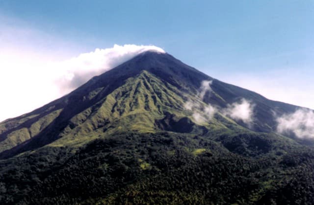
Karangetang is classified as a Stratovolcano. Stratovolcanoes (also called composite volcanoes) are steep, conical volcanoes built up by many layers of hardened lava, tephra, and volcanic ash. They are among the most common and dangerous types, known for explosive eruptions.
Where is Karangetang located?+
Karangetang is located in Indonesia, in the Western Pacific Volcanic Regions. More specifically, it lies within the Sangihe Volcanic Arc. Its exact coordinates are 2.781° latitude, 125.407° longitude.
Is it safe to visit Karangetang?+
Visiting Karangetang requires checking current volcanic activity and alert levels. As an active volcano with eruptions as recent as 2023 CE, conditions can change rapidly. Always consult local geological authorities and follow official warnings before visiting. Many active volcanoes have designated safe viewing areas and guided tour options.