About Tangkoko-Duasudara
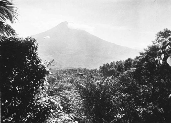
Tangkoko-Duasudara is a stratovolcano rising to 1,334 meters (4,377 feet) in Indonesia's Western Pacific Volcanic Regions. Its last known eruption was in 1880 CE. The volcano has produced 7 recorded eruptions, with a maximum Volcanic Explosivity Index (VEI) of 5.
Geography & Climate
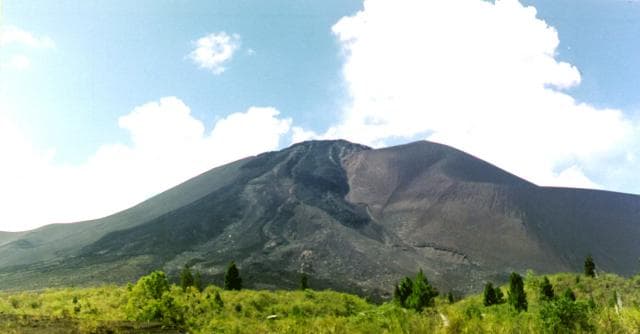
Tangkoko-Duasudara is located in Indonesia, within the Sangihe Volcanic Arc of the broader Western Pacific Volcanic Regions. Situated at 1.52° N, 125.19° E in the Northern Hemisphere, the volcano lies within a tropical climate zone. With a summit elevation of 1,334 meters above sea level, Tangkoko-Duasudara is a moderately sized peak that remains accessible to hikers and researchers for much of the year. The volcanic landform is characterized as a composite, which describes the physical shape and structure of the volcanic edifice as observed from the surface.
Geological Context
Tangkoko-Duasudara sits in a subduction zone, where one tectonic plate dives beneath another, creating intense heat and pressure that generates magma. Subduction zones are responsible for many of the world's most explosive volcanoes and deadliest eruptions. For communities in Indonesia near Tangkoko-Duasudara, this tectonic setting means the volcano is capable of producing powerful explosive eruptions, pyroclastic flows, and lahars that can threaten populated areas within tens of kilometers of the summit. The dominant rock type is andesite / basaltic andesite, a dark, fine-grained volcanic rock that forms from rapidly cooling, low-viscosity lava. Basaltic eruptions tend to be less explosive and produce fluid lava flows that can travel long distances. While less immediately dangerous than explosive eruptions, basaltic lava flows can destroy structures and infrastructure in their path, and volcanic gases released during these eruptions can affect air quality over a wide area.
Eruption History Summary
Tangkoko-Duasudara has 7 recorded eruptions in the geological database, spanning from 1680 CE to 1880 CE. The most powerful recorded event was a paroxysmal eruption with devastating regional consequences in 1680 CE, reaching VEI 5 on the Volcanic Explosivity Index. Notable eruptions include 1694 CE (VEI 3), 1683 CE (VEI 3), 1680 CE (VEI 5). This eruption frequency indicates a moderately active volcanic system with periodic reawakenings.
Significance
With a maximum recorded VEI of 5, Tangkoko-Duasudara has demonstrated the capacity for paroxysmal eruptions comparable to the 1980 eruption of Mount St. Helens. Eruptions of this scale can devastate areas within 20-30 kilometers and produce ash fall that disrupts aviation and agriculture across hundreds of kilometers. With 7 recorded eruptions on file, Tangkoko-Duasudara has enough documented activity to help scientists identify patterns in its eruptive behavior.
GVP Reference Summary
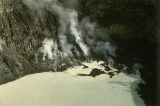
The eastern peninsula at the far NE end of Sulawesi near the city of Bitung is occupied by a volcanic complex consisting of two major edifices within a nature reserve. To the north is Tangkoko (also known as Tongkoko), with a large caldera (~3 x 1.5 km) elongated towards the SE from the highest rim point; the rim at the opposite end is more than 400 m lower. Eruptions occurred from the summit crater in the 17th century and in 1801, when the caldera also reportedly contained a cone surrounded by a lake. About 1.5 km down the outer E flank is the Batuangus (or Batu Angus) lava dome, formed in 1801, along with an adjacent vent (Baru Batuangus) that has been the source of all subsequent eruptions. The higher Duasudara (also Dua Suadara) edifice is ~4.5 km SW of the Tangkoko summit. A NE-facing scarp appears to have a hummocky debris flow that reaches the base of Tangkoko.
— Smithsonian Institution, Global Volcanism Program
7 Recorded Eruptions
| Year | VEI | Type | Area |
|---|---|---|---|
| 1880 | 1 | Confirmed Eruption | Batu Angus |
| 1843 | 2 | Confirmed Eruption | Batu Angus |
| 1821 | 0 | Confirmed Eruption | Batu Angus Baru |
| 1801 | 2 | Confirmed Eruption | Summit and east flank (Batu Angus) |
| 1694 | 3 | Confirmed Eruption | — |
| 1683 | 3 | Confirmed Eruption | — |
| 1680 | 5 | Confirmed Eruption | — |
Real-Time Data
Frequently Asked Questions About Tangkoko-Duasudara
Is Tangkoko-Duasudara an active volcano?+
Tangkoko-Duasudara is classified as active based on credible evidence of past eruptions. Although its last known eruption was in 1880 CE, volcanologists consider it capable of erupting again.
When did Tangkoko-Duasudara last erupt?+
The most recent recorded eruption of Tangkoko-Duasudara occurred in 1880 CE with a Volcanic Explosivity Index (VEI) of 1. The eruption was classified as a "Confirmed Eruption." Tangkoko-Duasudara has 7 recorded eruptions in total.
How high is Tangkoko-Duasudara?+
Tangkoko-Duasudara has a summit elevation of 1,334 meters (4,377 feet) above sea level. At 1,334 meters, it is a moderately sized volcanic peak, roughly comparable to Mount Vesuvius (1,281m).
What type of volcano is Tangkoko-Duasudara?+
Tangkoko-Duasudara is classified as a Stratovolcano. Stratovolcanoes (also called composite volcanoes) are steep, conical volcanoes built up by many layers of hardened lava, tephra, and volcanic ash. They are among the most common and dangerous types, known for explosive eruptions.
Where is Tangkoko-Duasudara located?+
Tangkoko-Duasudara is located in Indonesia, in the Western Pacific Volcanic Regions. More specifically, it lies within the Sangihe Volcanic Arc. Its exact coordinates are 1.518° latitude, 125.185° longitude.
Is it safe to visit Tangkoko-Duasudara?+
Tangkoko-Duasudara can generally be visited, but as with any volcano, visitors should check local conditions and any advisory notices before traveling. Indonesia may have specific regulations for accessing volcanic areas. Guided tours are often the safest and most informative way to experience a volcano.