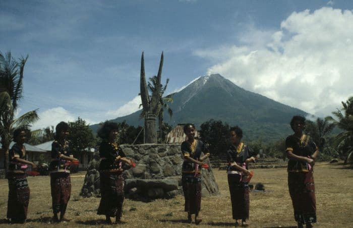
About Iya
Iya is a stratovolcano rising to 618 meters (2,028 feet) in Indonesia's Sunda-Banda Volcanic Regions. It last erupted in 1969 CE, and volcanologists consider it an active volcanic system. The volcano has produced 11 recorded eruptions, with a maximum Volcanic Explosivity Index (VEI) of 3.
Geography & Climate
Iya is located in Indonesia, within the Sunda Volcanic Arc of the broader Sunda-Banda Volcanic Regions. Situated at 8.89° S, 121.64° E in the Southern Hemisphere, the volcano lies within a tropical climate zone. With a summit elevation of 618 meters above sea level, Iya is a moderately sized peak that remains accessible to hikers and researchers for much of the year. The volcanic landform is characterized as a composite, which describes the physical shape and structure of the volcanic edifice as observed from the surface.
Geological Context
Iya sits in a subduction zone, where one tectonic plate dives beneath another, creating intense heat and pressure that generates magma. Subduction zones are responsible for many of the world's most explosive volcanoes and deadliest eruptions. For communities in Indonesia near Iya, this tectonic setting means the volcano is capable of producing powerful explosive eruptions, pyroclastic flows, and lahars that can threaten populated areas within tens of kilometers of the summit. The dominant rock type is basalt / picro-basalt, a dark, fine-grained volcanic rock that forms from rapidly cooling, low-viscosity lava. Basaltic eruptions tend to be less explosive and produce fluid lava flows that can travel long distances. While less immediately dangerous than explosive eruptions, basaltic lava flows can destroy structures and infrastructure in their path, and volcanic gases released during these eruptions can affect air quality over a wide area.
Eruption History Summary
Iya has 11 recorded eruptions in the geological database, spanning from 1559 CE to 1971 CE. The most powerful recorded event was a severe eruption capable of regional ash fall and pyroclastic flows in 1969 CE, reaching VEI 3 on the Volcanic Explosivity Index. Notable eruptions include 1969 CE (VEI 3), 1671 CE (VEI 3). This level of eruptive frequency indicates a persistently active volcanic system that warrants ongoing monitoring. The most recent eruption in 1971 CE places this volcano within the modern era of volcanological observation.
Significance
With a maximum recorded VEI of 3, Iya has produced eruptions capable of generating pyroclastic flows and significant ash fall in the surrounding area. While not among the largest eruptions globally, VEI 3 events pose serious hazards to local populations and can disrupt regional air travel. With 11 recorded eruptions, Iya has a substantial eruptive history that provides valuable data for understanding volcanic behavior and assessing future hazards in the Sunda-Banda Volcanic Regions region. Given its recent activity, Iya is closely monitored by geological survey organizations to provide early warning of future unrest.
GVP Reference Summary
Gunung Iya is the southernmost of a group of three volcanoes comprising a small peninsula south of the city of Ende on central Flores Island. The cones to the north, Rooja and Pui, appear to be slightly older and have not shown historical activity, although Pui has a youthful profile (a reported 1671 eruption of Pui was considered to have originated from Iya volcano). Iya, whose truncated southern side drops steeply to the sea, has had numerous moderate explosive eruptions during historical time.
— Smithsonian Institution, Global Volcanism Program
11 Recorded Eruptions
| Year | VEI | Type | Area |
|---|---|---|---|
| 1971 | 1 | Uncertain Eruption | — |
| 1969 | 3 | Confirmed Eruption | Crater II (upper SW flank) |
| 1953 | 2 | Confirmed Eruption | — |
| 1888 | — | Uncertain Eruption | — |
| 1882 | 2 | Confirmed Eruption | — |
| 1871 | 2 | Confirmed Eruption | — |
| 1868 | 2 | Confirmed Eruption | — |
| 1867 | 2 | Confirmed Eruption | — |
| 1844 | 2 | Confirmed Eruption | — |
| 1671 | 3 | Confirmed Eruption | — |
| 1559 | — | Uncertain Eruption | — |
Real-Time Data
Frequently Asked Questions About Iya
Is Iya an active volcano?+
Yes, Iya is considered an active volcano. Its most recent eruption was in 1969 CE. The volcano is monitored by geological agencies, and its activity status is based on observed eruptions within recorded history.
When did Iya last erupt?+
The most recent recorded eruption of Iya occurred in 1971 CE with a Volcanic Explosivity Index (VEI) of 1. The eruption was classified as a "Uncertain Eruption." Iya has 11 recorded eruptions in total.
How high is Iya?+
Iya has a summit elevation of 618 meters (2,028 feet) above sea level. At 618 meters, it is a relatively low-elevation volcano.
What type of volcano is Iya?+
Iya is classified as a Stratovolcano. Stratovolcanoes (also called composite volcanoes) are steep, conical volcanoes built up by many layers of hardened lava, tephra, and volcanic ash. They are among the most common and dangerous types, known for explosive eruptions.
Where is Iya located?+
Iya is located in Indonesia, in the Sunda-Banda Volcanic Regions. More specifically, it lies within the Sunda Volcanic Arc. Its exact coordinates are -8.891° latitude, 121.641° longitude.
Is it safe to visit Iya?+
Visiting Iya requires checking current volcanic activity and alert levels. As an active volcano with eruptions as recent as 1969 CE, conditions can change rapidly. Always consult local geological authorities and follow official warnings before visiting. Many active volcanoes have designated safe viewing areas and guided tour options.