About Dana
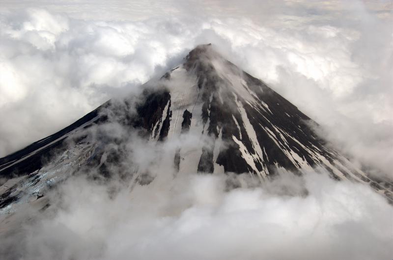
Dana is a stratovolcano rising to 1,354 meters (4,442 feet) in United States's North America Volcanic Regions. Its last known eruption dates to 1890 BCE, in prehistoric times. The volcano has produced 1 recorded eruption, with a maximum Volcanic Explosivity Index (VEI) of 5.
Geography & Climate
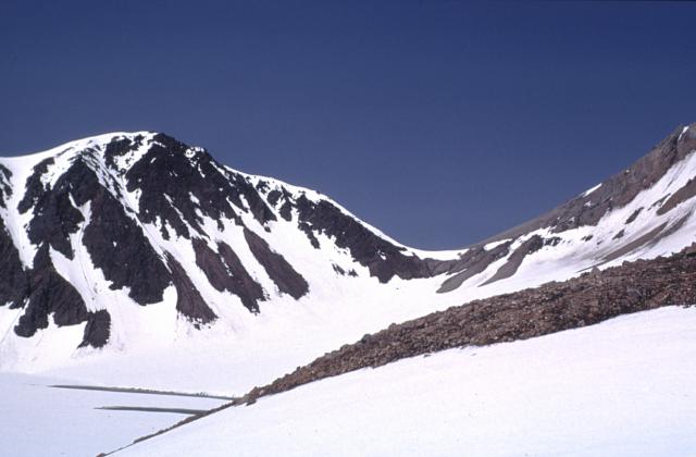
Dana is located in United States, within the Aleutian Ridge Volcanic Arc of the broader North America Volcanic Regions. Situated at 55.64° N, 161.21° W in the Northern Hemisphere, the volcano lies within a subarctic climate zone. With a summit elevation of 1,354 meters above sea level, Dana is a moderately sized peak that remains accessible to hikers and researchers for much of the year. The volcanic landform is characterized as a composite, which describes the physical shape and structure of the volcanic edifice as observed from the surface.
Geological Context
Dana sits in a subduction zone, where one tectonic plate dives beneath another, creating intense heat and pressure that generates magma. Subduction zones are responsible for many of the world's most explosive volcanoes and deadliest eruptions. For communities in United States near Dana, this tectonic setting means the volcano is capable of producing powerful explosive eruptions, pyroclastic flows, and lahars that can threaten populated areas within tens of kilometers of the summit. The dominant rock type is andesite / basaltic andesite, a dark, fine-grained volcanic rock that forms from rapidly cooling, low-viscosity lava. Basaltic eruptions tend to be less explosive and produce fluid lava flows that can travel long distances. While less immediately dangerous than explosive eruptions, basaltic lava flows can destroy structures and infrastructure in their path, and volcanic gases released during these eruptions can affect air quality over a wide area.
Eruption History Summary
Dana has 1 recorded eruption in the geological database, spanning from 1890 BCE to 1890 BCE. The most powerful recorded event was a paroxysmal eruption with devastating regional consequences in 1890 BCE, reaching VEI 5 on the Volcanic Explosivity Index.
Significance
With a maximum recorded VEI of 5, Dana has demonstrated the capacity for paroxysmal eruptions comparable to the 1980 eruption of Mount St. Helens. Eruptions of this scale can devastate areas within 20-30 kilometers and produce ash fall that disrupts aviation and agriculture across hundreds of kilometers.
GVP Reference Summary
Mount Dana is a small calc-alkaline volcano NE of Canoe Bay inlet at the head of Pavlof Bay consisting of an apron of volcaniclastic debris surrounding a central dome complex. The high point is located at the north rim of a 1.5 x 2 km crater, whose SW rim exposes Mesozoic sedimentary rocks. Andesitic lava domes occur on the west crater rim and as a small mound east of Knutson Lake inside the crater. Dana is the source of a mid-Holocene block-and-ash flow that reached the sea at Canoe Bay. No historical eruptions are known, but a 200-m-wide tufa mound and several cold springs are located on the SW flank.
— Smithsonian Institution, Global Volcanism Program
1 Recorded Eruption
| Year | VEI | Type | Area |
|---|---|---|---|
| 1890 BCE | 5 | Confirmed Eruption | — |
Real-Time Data
Frequently Asked Questions About Dana
Is Dana an active volcano?+
Dana is not currently classified as active. Its activity evidence is listed as "Eruption Dated." The last known eruption was in 1890 BCE. However, no volcano is ever considered permanently extinct.
When did Dana last erupt?+
The most recent recorded eruption of Dana occurred in 1890 BCE with a Volcanic Explosivity Index (VEI) of 5. The eruption was classified as a "Confirmed Eruption." Dana has 1 recorded eruption in total.
How high is Dana?+
Dana has a summit elevation of 1,354 meters (4,442 feet) above sea level. At 1,354 meters, it is a moderately sized volcanic peak, roughly comparable to Mount Vesuvius (1,281m).
What type of volcano is Dana?+
Dana is classified as a Stratovolcano. Stratovolcanoes (also called composite volcanoes) are steep, conical volcanoes built up by many layers of hardened lava, tephra, and volcanic ash. They are among the most common and dangerous types, known for explosive eruptions.
Where is Dana located?+
Dana is located in United States, in the North America Volcanic Regions. More specifically, it lies within the Aleutian Ridge Volcanic Arc. Its exact coordinates are 55.641° latitude, -161.214° longitude.
Is it safe to visit Dana?+
Dana can generally be visited, but as with any volcano, visitors should check local conditions and any advisory notices before traveling. United States may have specific regulations for accessing volcanic areas. Guided tours are often the safest and most informative way to experience a volcano.