About Tuya Volcanic Field
Tuya Volcanic Field is a volcanic field rising to 2,123 meters (6,966 feet) in Canada's North America Volcanic Regions. No historical eruptions have been recorded, though the volcano is classified based on geological evidence of past activity.
Geography & Climate
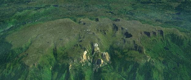
Tuya Volcanic Field is located in Canada, within the Northern Cordilleran Volcanic Province of the broader North America Volcanic Regions. Situated at 59.37° N, 130.58° W in the Northern Hemisphere, the volcano lies within a subarctic climate zone. At 2,123 meters above sea level, Tuya Volcanic Field rises above the surrounding terrain into montane or subalpine conditions. The elevation creates distinct ecological zones along its flanks, from forested lower slopes to exposed rocky terrain near the summit. The volcanic landform is characterized as a cluster, which describes the physical shape and structure of the volcanic edifice as observed from the surface.
Geological Context
Tuya Volcanic Field is an intraplate volcano, meaning it formed away from any plate boundary. These volcanoes are often powered by hotspots — plumes of abnormally hot mantle material rising from deep within the Earth. Hotspot volcanoes like Tuya Volcanic Field tend to produce effusive eruptions with lava flows that can be relatively predictable, giving nearby communities in Canada more time to prepare. However, they can also produce explosive phases, particularly when magma interacts with groundwater. The dominant rock type is basalt / picro-basalt, a dark, fine-grained volcanic rock that forms from rapidly cooling, low-viscosity lava. Basaltic eruptions tend to be less explosive and produce fluid lava flows that can travel long distances. While less immediately dangerous than explosive eruptions, basaltic lava flows can destroy structures and infrastructure in their path, and volcanic gases released during these eruptions can affect air quality over a wide area.
GVP Reference Summary
A broad region with numerous formerly subglacial volcanic cones known as tuyas forms the Tuya Volcanic Field near Tuya Lake and a broad area to the N. Although tuyas, the products of Pleistocene subglacial eruptions, are perhaps better known in Iceland, these predominantly flat-topped basaltic table mountains derive their name from the Tuya region in the Cassiar Mountains and Tanzilla Plateau area of northern British Columbia. Tuya Butte itself, immediately N of Tuya Lake, has no summit crater or obvious vent, suggesting fissure-fed eruptions, although several indications suggest a vent location near a large cirque on the N face. Other tuyas lie in the High Tuya Lake, Iverson Creek, Rancheria River, and Klinkit Lake areas. Several small subaerial shield volcanoes, and postglacial lapilli cones and lava flows have been reported in this area. At least one of these, Grabrielse Cone near the headwaters of Iverson Creek, is of Holocene age.
— Smithsonian Institution, Global Volcanism Program
0 Recorded Eruptions
No eruption records available for Tuya Volcanic Field.
Real-Time Data
Frequently Asked Questions About Tuya Volcanic Field
Is Tuya Volcanic Field an active volcano?+
Tuya Volcanic Field is classified as active based on credible evidence of past eruptions. Although its last known eruption was in prehistoric times, volcanologists consider it capable of erupting again.
How high is Tuya Volcanic Field?+
Tuya Volcanic Field has a summit elevation of 2,123 meters (6,966 feet) above sea level. At 2,123 meters, it is comparable in height to many significant mountain peaks and stands well above the tree line.
What type of volcano is Tuya Volcanic Field?+
Tuya Volcanic Field is classified as a Volcanic field. Volcanic fields consist of clusters of small volcanic vents and cinder cones spread across a region. Rather than a single central vent, eruptions can occur at many points across the field.
Where is Tuya Volcanic Field located?+
Tuya Volcanic Field is located in Canada, in the North America Volcanic Regions. More specifically, it lies within the Northern Cordilleran Volcanic Province. Its exact coordinates are 59.370° latitude, -130.580° longitude.
Is it safe to visit Tuya Volcanic Field?+
Tuya Volcanic Field can generally be visited, but as with any volcano, visitors should check local conditions and any advisory notices before traveling. Canada may have specific regulations for accessing volcanic areas. Guided tours are often the safest and most informative way to experience a volcano.