About Kita-Fukutokutai
Kita-Fukutokutai is a stratovolcano rising to -73 meters (-240 feet) in Japan's Northwestern Pacific Volcanic Regions. It last erupted in 1954 CE, and volcanologists consider it an active volcanic system. The volcano has produced 6 recorded eruptions, with a maximum Volcanic Explosivity Index (VEI) of 1.
Geography & Climate
Kita-Fukutokutai is located in Japan, within the Ogasawara Volcanic Arc of the broader Northwestern Pacific Volcanic Regions. Situated at 24.42° N, 141.42° E in the Northern Hemisphere, the volcano lies within a subtropical climate zone. With an elevation of -73 meters — below sea level — Kita-Fukutokutai is a submarine or submerged volcanic feature. Submarine volcanoes make up the majority of Earth's volcanic activity, though most eruptions go unobserved beneath the ocean surface. The volcanic landform is characterized as a composite, which describes the physical shape and structure of the volcanic edifice as observed from the surface.
Geological Context
Kita-Fukutokutai sits in a subduction zone, where one tectonic plate dives beneath another, creating intense heat and pressure that generates magma. Subduction zones are responsible for many of the world's most explosive volcanoes and deadliest eruptions. For communities in Japan near Kita-Fukutokutai, this tectonic setting means the volcano is capable of producing powerful explosive eruptions, pyroclastic flows, and lahars that can threaten populated areas within tens of kilometers of the summit. The dominant rock type is no data (checked), which influences the viscosity of the magma and, consequently, the style of eruptions this volcano produces. Rock chemistry is one of the most important factors in determining whether a volcano erupts explosively or effusively.
Eruption History Summary
Kita-Fukutokutai has 6 recorded eruptions in the geological database, spanning from 1937 CE to 2001 CE. The most powerful recorded event was a gentle, effusive event in 1988 CE, reaching VEI 1 on the Volcanic Explosivity Index. This eruption frequency indicates a moderately active volcanic system with periodic reawakenings. With eruptive activity as recently as 2001 CE, Kita-Fukutokutai remains an actively monitored volcano.
Significance
With 6 recorded eruptions on file, Kita-Fukutokutai has enough documented activity to help scientists identify patterns in its eruptive behavior. Given its recent activity, Kita-Fukutokutai is closely monitored by geological survey organizations to provide early warning of future unrest.
GVP Reference Summary
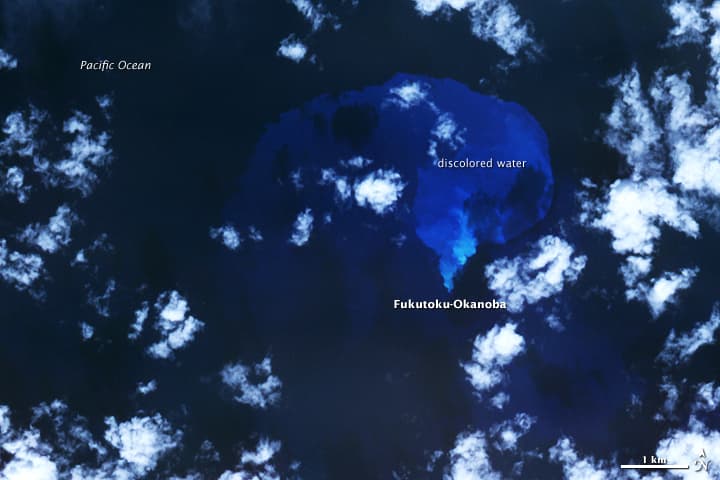
Kita-Fukutokutai is a submarine volcano halfway between the Ioto and Minami-Ioto islands. The volcano rises to within 73 m of the ocean surface. Water discoloration was reported several times beginning in 1937, and floating pumice was seen during 1953-54. In 1988 a fishing boat reported an eruption column about 100 m high, although the report was not confirmed at the time. The Japan Meteorological Agency has classified Kita-Fukutokutai as an active volcano.
— Smithsonian Institution, Global Volcanism Program
6 Recorded Eruptions
| Year | VEI | Type | Area |
|---|---|---|---|
| 2001 | 0 | Uncertain Eruption | 24.443 N, 141.378 E |
| 1988 | 1 | Uncertain Eruption | — |
| 1959 | 0 | Uncertain Eruption | — |
| 1953 | 0 | Confirmed Eruption | — |
| 1947 | 0 | Uncertain Eruption | — |
| 1937 | 0 | Uncertain Eruption | — |
Real-Time Data
Frequently Asked Questions About Kita-Fukutokutai
Is Kita-Fukutokutai an active volcano?+
Yes, Kita-Fukutokutai is considered an active volcano. Its most recent eruption was in 1954 CE. The volcano is monitored by geological agencies, and its activity status is based on observed eruptions within recorded history.
When did Kita-Fukutokutai last erupt?+
The most recent recorded eruption of Kita-Fukutokutai occurred in 2001 CE with a Volcanic Explosivity Index (VEI) of 0. The eruption was classified as a "Uncertain Eruption." Kita-Fukutokutai has 6 recorded eruptions in total.
How high is Kita-Fukutokutai?+
Kita-Fukutokutai has a summit elevation of -73 meters (-240 feet) above sea level. With an elevation of -73 meters (below sea level), this is a submarine or submerged volcanic feature.
What type of volcano is Kita-Fukutokutai?+
Kita-Fukutokutai is classified as a Stratovolcano. Stratovolcanoes (also called composite volcanoes) are steep, conical volcanoes built up by many layers of hardened lava, tephra, and volcanic ash. They are among the most common and dangerous types, known for explosive eruptions.
Where is Kita-Fukutokutai located?+
Kita-Fukutokutai is located in Japan, in the Northwestern Pacific Volcanic Regions. More specifically, it lies within the Ogasawara Volcanic Arc. Its exact coordinates are 24.417° latitude, 141.417° longitude.
Is it safe to visit Kita-Fukutokutai?+
Visiting Kita-Fukutokutai requires checking current volcanic activity and alert levels. As an active volcano with eruptions as recent as 1954 CE, conditions can change rapidly. Always consult local geological authorities and follow official warnings before visiting. Many active volcanoes have designated safe viewing areas and guided tour options.