About Singkut
Singkut is a caldera(s) rising to 2,181 meters (7,156 feet) in Indonesia's Sunda-Banda Volcanic Regions. Its last known eruption was in 1881 CE. The volcano has produced 1 recorded eruption.
Geography & Climate
Singkut is located in Indonesia, within the Sunda Volcanic Arc of the broader Sunda-Banda Volcanic Regions. Situated at 3.24° N, 98.51° E in the Northern Hemisphere, the volcano lies within a tropical climate zone. At 2,181 meters above sea level, Singkut rises above the surrounding terrain into montane or subalpine conditions. The elevation creates distinct ecological zones along its flanks, from forested lower slopes to exposed rocky terrain near the summit. The volcanic landform is characterized as a caldera, which describes the physical shape and structure of the volcanic edifice as observed from the surface.
Geological Context
Singkut sits in a subduction zone, where one tectonic plate dives beneath another, creating intense heat and pressure that generates magma. Subduction zones are responsible for many of the world's most explosive volcanoes and deadliest eruptions. For communities in Indonesia near Singkut, this tectonic setting means the volcano is capable of producing powerful explosive eruptions, pyroclastic flows, and lahars that can threaten populated areas within tens of kilometers of the summit. The dominant rock type is andesite / basaltic andesite, a dark, fine-grained volcanic rock that forms from rapidly cooling, low-viscosity lava. Basaltic eruptions tend to be less explosive and produce fluid lava flows that can travel long distances. While less immediately dangerous than explosive eruptions, basaltic lava flows can destroy structures and infrastructure in their path, and volcanic gases released during these eruptions can affect air quality over a wide area.
Eruption History Summary
Singkut has 1 recorded eruption in the geological database, spanning from 1881 CE to 1881 CE.
GVP Reference Summary
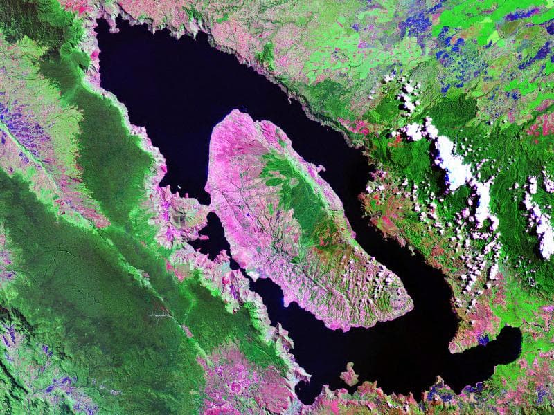
The Quaternary Singkut caldera is about 7 x 4 km with the S half of the rim topographically distinct. Post-caldera cones have filled much of the crater and the N rim, including Sibayak, Pintau, and Pratektekan. The 900-m-wide Sibayak crater is partially filled on the north by Pintau. A lava flow traveled through a gap in the western crater wall from the summit lava dome of Sibayak; the active geothermal field SE of the summit has abundant solfataras and fumaroles. Area residents record legends of eruptions. Neumann van Padang (1983) cited a report by Hoekstra of ash clouds emitted from the volcano in 1881. The town of Berastagi is within the caldera immediately SE of the younger cones.
— Smithsonian Institution, Global Volcanism Program
1 Recorded Eruption
| Year | VEI | Type | Area |
|---|---|---|---|
| 1881 | — | Confirmed Eruption | — |
Real-Time Data
Frequently Asked Questions About Singkut
Is Singkut an active volcano?+
Singkut is classified as active based on credible evidence of past eruptions. Although its last known eruption was in 1881 CE, volcanologists consider it capable of erupting again.
When did Singkut last erupt?+
The most recent recorded eruption of Singkut occurred in 1881 CE. The eruption was classified as a "Confirmed Eruption." Singkut has 1 recorded eruption in total.
How high is Singkut?+
Singkut has a summit elevation of 2,181 meters (7,156 feet) above sea level. At 2,181 meters, it is comparable in height to many significant mountain peaks and stands well above the tree line.
What type of volcano is Singkut?+
Singkut is classified as a Caldera(s). Caldera(s) volcanoes have distinct geological characteristics that set them apart from other volcanic types.
Where is Singkut located?+
Singkut is located in Indonesia, in the Sunda-Banda Volcanic Regions. More specifically, it lies within the Sunda Volcanic Arc. Its exact coordinates are 3.238° latitude, 98.513° longitude.
Is it safe to visit Singkut?+
Singkut can generally be visited, but as with any volcano, visitors should check local conditions and any advisory notices before traveling. Indonesia may have specific regulations for accessing volcanic areas. Guided tours are often the safest and most informative way to experience a volcano.